Xindian River
| Xindian River | |
|---|---|
 Xindian River | |
| Country | Taiwan |
| Basin | |
| Main source |
Yingzi Mountain Range 700 metres (2,300 ft) |
| River system | Tamsui River |
| Basin size | 921 square kilometres (356 sq mi) |
| Physical characteristics | |
| Length | 81 kilometres (50 mi) |
| Features | |
| Tributaries |
|
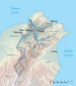
The Xindian River (or Xindian Creek) (Chinese: 新店溪; pinyin: Xīndiàn Xī; Wade–Giles: Hsin1-tien4 Hsi1; Pe̍h-ōe-jī: Sin-tiàm-khe) is a creek in northern Taiwan. It flows through New Taipei and the capital Taipei for 82 km.[1]
Overview
The Xindian River is one of the three major tributaries into the Tamsui River. Its main tributary is the Beishi River which originates in Shuangxi District, New Taipei City at an elevation of 700 meters.[2] The Feitsui Dam spans the Beishi southeast of Taipei. It flows west past Xindian before merging with the Nanshi River; it is at this point that it becomes "Xindian River". It then turns north and merges with the Chingmei River, before finally merging with the Dahan River and feeding into the Tamsui River.
The creek is one of the main sources for drinking water in Taipei City. According to the Taipei City Running Water Center, over 4 million Taipei residents obtain 97% of their drinking water from the river. The first bridge over the creek was constructed in 1937 and at 200 meters long connected the areas of Zhonghe and Xindian. Today, there are 22 bridges that span the creek.
Pollution
The Xindian Creek is heavily polluted by both raw sewage and industrial pollution from illegal industry.[3] [4] [5] The natural watercourse restoration is on the agenda of the Taipei City Government, Taiwan Central Government and several citizen organizations.[6]
See also
| Wikimedia Commons has media related to Xindian Creek. |
External links
References
- ↑ Reilly, Julie (1984). "The small city of Hsin Tien is, in no way, another formless suburb of Taipei". Taiwan Review. Retrieved 14 July 2014.
From every point in Hsin Tien one feels the magnetic attraction of the Hsin Tien River. It is its heart, and indeed the key to its history and development.
- ↑ 楊萬全,認識淡水河流域的水文,台灣水文論文集,2000年5月,第524頁
- ↑ Lohani, B. N.; Hee, Kee Book (1983). "A CCDP model for water quality management in the Hsintien river in Taiwan". International Journal of Water Resources Development. 1 (2): 91–114. doi:10.1080/07900628308722279.
- ↑ Chen, Lon-Gyi; Phien, Huynh Ngoc (January 1983). "Dynamo water quality modelling for the Hsintien River, Taiwan" (PDF). Water SA. 9 (1): 9.
- ↑ Lohani, B. N.; Thanh, N. C. (June 1978). "Water quality management in the Hsintien River in Taiwan". JAWRA Journal of the American Water Resources Association. 14 (3): 689–695. doi:10.1111/j.1752-1688.1978.tb02217.x.
- ↑ Taipei from the River - Marco Casagrande, E-Architect March, 2011
Coordinates: 25°02′33″N 121°29′02″E / 25.0426°N 121.4840°E