Xaloztoc
| Xaloztoc (municipality) | ||
|---|---|---|
| Municipality | ||
| ||
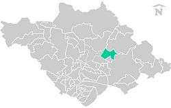 Location of the municipality in Tlaxcala. | ||
|
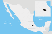
Xaloztoc (municipality) Location in Mexico | ||
| Coordinates: 19°24′00″N 98°3′0″W / 19.40000°N 98.05000°WCoordinates: 19°24′00″N 98°3′0″W / 19.40000°N 98.05000°W | ||
| Country |
| |
| State |
| |
| Established | November 25th, 1873 | |
| Area | ||
| • Total | 49 km2 (19 sq mi) | |
| Elevation | 2,500 m (8,200 ft) | |
| Population (2010) | ||
| • Total | 21,769 | |
| • Density | 444.27/km2 (1,150.7/sq mi) | |
| Time zone | Central Standard Time (UTC-6) | |
| • Summer (DST) | Central Daylight Time (UTC-5) | |
| Area code(s) | 241 | |
Xaloztoc (municipality) is a municipality in Tlaxcala in south-eastern Mexico. It is one of 60 municipalities in the state, and serves as the capital of Tlaxcala. The INEGI reference number for the municipality is 29039.[1]
Geography
As of 2010, Xaloztoc has an estimated 21,769 residents. The size of the municipality is about 49 km2 (19 sq mi). The average elevation is 2,500 meters (8,200 ft) above sea level.
Climate
On average, Xaloztoc receives 730.3 mm/m2 (28.8 in) of precipitation annually. The average yearly temperature for the area is approximately 14.8 °C (58.6 °F).
References
- ↑ "-". Enciclopedia de los Municipios de México. Instituto Nacional para el Federalismo y el Desarrollo Municipal. Retrieved January 4, 2010.
This article is issued from Wikipedia - version of the 6/27/2016. The text is available under the Creative Commons Attribution/Share Alike but additional terms may apply for the media files.