Wyoming Highway 251
| ||||
|---|---|---|---|---|
|
Casper Mountain Road S. Wolcott Street | ||||
| Route information | ||||
| Maintained by WYDOT, City of Casper | ||||
| Length: | 8.99 mi[1] (14.47 km) | |||
| Major junctions | ||||
| South end: |
| |||
| North end: |
| |||
| Location | ||||
| Counties: | Natrona | |||
| Highway system | ||||
| ||||

Wyoming Highway 252 is a 8.99-mile (14.5 km) north-south Wyoming state road located in Natrona County.
Route description
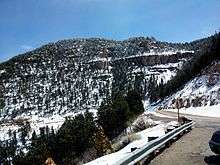
Wyoming Highway 251 begins its southern end at Natrona CR 505 in the census-designated place (CDP) of Casper Mountain, south of the City of Casper. The southern terminus of WYO 252 lies on the Casper Mountain summit at an elevation of 8,485 feet and provides access to the Hogadon Ski Area.[2] Natrona CR 505 continues southwest of the Casper Mountain area and meets County Route 401, which links to Wyoming Highway 487.[3] Highway 251 proceeds northward as it zig-zags down off Casper Mountain. At the base, the southern terminus of Wyoming Highway 252 (Garden Creek Road) is intersected at just under 4 miles. Past WYO 252, Highway 251 now on a straighter course, enters the Casper city limits and reaches Wyoming Highway 258 also known as Wyoming Boulevard at 5.7 miles.[1][3] Highway 251 continues northward and changes names to South Walcott Street. WYO 251 gently curves around the west side of the Casper Golf Club and the east side of Casper College before entering downtown Casper. The northern terminus of Highway 251 lies at the business routes of I-25/US 20/US 26/US 87 (E. 1st Street) in Casper.
The last 2.01 miles (3.2 km) of Highway 251 are maintained by the City of Casper.[2]
Major intersections
The entire route is in Natrona County.
| Location | mi | km | Destinations | Notes | |
|---|---|---|---|---|---|
| Casper Mountain | 0.00 | 0.00 | Southern Terminus of WYO 251 | ||
| south of Casper | 3.95 | 6.36 | Southern Terminus of WYO 252 | ||
| Casper | 5.86 | 9.43 | |||
| 8.99 | 14.47 | Northern Terminus of WYO 251 | |||
| 1.000 mi = 1.609 km; 1.000 km = 0.621 mi | |||||
References
- 1 2 Wyoming Department of Transportation Reference Marker Book - November 2004 (PDF) (Map). WYDOT. Archived from the original (PDF) on July 17, 2011. Retrieved 2011-03-31.
- 1 2 aaroads.com - Wyoming Routes 200-299
- 1 2 Google (14 November 2011). "Overview Map of Wyoming Highway 251" (Map). Google Maps. Google. Retrieved 14 November 2011.
External links
- Wyoming State Routes 200-299
- WYO 251 - WYO 252 to Casper Mountain
- WYO 251 - WYO 258 to WYO 252
- WYO 251 - Casper College to WYO 258