Wyoming, Delaware
| Wyoming, Delaware | |
|---|---|
| Town | |
|
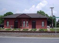
Railroad depot in Wyoming | |
 Location in Kent County and the state of Delaware. | |
| Coordinates: 39°7′5″N 75°33′28″W / 39.11806°N 75.55778°WCoordinates: 39°7′5″N 75°33′28″W / 39.11806°N 75.55778°W | |
| Country | United States |
| State | Delaware |
| County | Kent |
| Area | |
| • Total | 0.7 sq mi (1.8 km2) |
| • Land | 0.7 sq mi (1.7 km2) |
| • Water | 0.0 sq mi (0.0 km2) |
| Elevation | 43 ft (13 m) |
| Population (2010) | |
| • Total | 1,313 |
| • Density | 1,690.0/sq mi (652.5/km2) |
| Time zone | Eastern (EST) (UTC-5) |
| • Summer (DST) | EDT (UTC-4) |
| ZIP code | 19934 |
| Area code(s) | 302 |
| FIPS code | 10-81350 |
| GNIS feature ID | 0217870 |
Wyoming is a town in Kent County, Delaware, United States. It was named after the Wyoming Valley in Pennsylvania. It is part of the Dover, Delaware Metropolitan Statistical Area. The population was 1,313 at the 2010 census.[1]
History
The community started when the nearby town of Camden, Delaware would not grant access to the Pennsylvania Railroad, which bypassed the town and built a railroad station one mile west of the center of town and named the area West Camden. In 1865, minister John J. Pierce moved to West Camden from the Wyoming Valley and laid out plots for new housing. Several individuals from the Wyoming Valley moved to the new community and it was decided to rename the community.[2] The community, "Desiring to sever any shared identity or connection with Camden, residents chose to honor the new citizens by changing the name of the community to Wyoming." A post office was erected in 1866 and the community was incorporated into a town in 1869.[3]
The Lewis Family Tenant Agricultural Complex, Wyoming Historic District, and Wyoming Railroad Station are listed on the National Register of Historic Places.[4]
Geography
Wyoming is located at 39°7′5″N 75°33′28″W / 39.11806°N 75.55778°W (39.117950, -75.557867).[5]
According to the United States Census Bureau, the town has a total area of 0.7 square miles (1.8 km2), of which, 0.7 square miles (1.8 km2) of it is land and 0.04 square miles (0.10 km2) of it (2.90%) is water.
Demographics
| Historical population | |||
|---|---|---|---|
| Census | Pop. | %± | |
| 1870 | 280 | — | |
| 1880 | 353 | 26.1% | |
| 1890 | 497 | 40.8% | |
| 1900 | 450 | −9.5% | |
| 1910 | 517 | 14.9% | |
| 1920 | 661 | 27.9% | |
| 1930 | 684 | 3.5% | |
| 1940 | 870 | 27.2% | |
| 1950 | 911 | 4.7% | |
| 1960 | 1,172 | 28.6% | |
| 1970 | 1,062 | −9.4% | |
| 1980 | 960 | −9.6% | |
| 1990 | 977 | 1.8% | |
| 2000 | 1,141 | 16.8% | |
| 2010 | 1,313 | 15.1% | |
| Est. 2015 | 1,465 | [6] | 11.6% |
As of the census[8] of 2000, there were 1,141 people, 448 households, and 315 families residing in the town. The population density was 1,690.0 people per square mile (647.9/km²). There were 485 housing units at an average density of 718.3 per square mile (275.4/km²). The racial makeup of the town was 79.49% White, 13.32% African American, 0.09% Native American, 3.86% Asian, 0.53% from other races, and 2.72% from two or more races. Hispanic or Latino of any race were 2.54% of the population.
There were 448 households out of which 32.8% had children under the age of 18 living with them, 52.5% were married couples living together, 12.7% had a female householder with no husband present, and 29.5% were non-families. 24.1% of all households were made up of individuals and 7.4% had someone living alone who was 65 years of age or older. The average household size was 2.55 and the average family size was 2.99.
In the town the population was spread out with 25.0% under the age of 18, 7.9% from 18 to 24, 31.4% from 25 to 44, 22.8% from 45 to 64, and 13.0% who were 65 years of age or older. The median age was 37 years. For every 100 females there were 99.1 males. For every 100 females age 18 and over, there were 92.8 males.
The median income for a household in the town was $48,452, and the median income for a family was $54,265. Males had a median income of $35,625 versus $25,741 for females. The per capita income for the town was $21,254. About 1.8% of families and 3.6% of the population were below the poverty line, including 3.6% of those under age 18 and 3.4% of those age 65 or over.
Local attractions
The "Wyoming Peach Festival" occurs every August. It offers pageants, homemade peach ice cream and tours of Fifer Orchards, which is the largest peach and apple producer in the state of Delaware.
References
- ↑ http://www.stateplanning.delaware.gov/census_data_center/
- ↑ http://www.delawareonline.com/article/20130820/NEWS/308200065/Old-feud-between-Camden-Wyoming-part-local-lore?nclick_check=1
- ↑ http://archives.delaware.gov/markers/kc/KC-63.shtml#TopOfPage
- ↑ National Park Service (2010-07-09). "National Register Information System". National Register of Historic Places. National Park Service.
- ↑ "US Gazetteer files: 2010, 2000, and 1990". United States Census Bureau. 2011-02-12. Retrieved 2011-04-23.
- ↑ "Annual Estimates of the Resident Population for Incorporated Places: April 1, 2010 to July 1, 2015". Retrieved July 2, 2016.
- ↑ "Census of Population and Housing". Census.gov. Archived from the original on May 11, 2015. Retrieved June 4, 2015.
- ↑ "American FactFinder". United States Census Bureau. Archived from the original on September 11, 2013. Retrieved 2008-01-31.
External links
Municipalities and communities of Kent County, Delaware, United States | ||
|---|---|---|
| Cities | ||
| Towns | ||
| CDPs | ||
| Unincorporated communities |
| |
| Hundreds | ||
| Footnotes | ‡This populated place also has portions in an adjacent county or counties | |