Worlebury Hill
| Worlebury Hill | |
|---|---|
 The western end of the hill viewed from the south across Marine Lake | |
| Highest point | |
| Coordinates | 51°21′28″N 2°58′49″W / 51.357874°N 2.98017°WCoordinates: 51°21′28″N 2°58′49″W / 51.357874°N 2.98017°W |
| Geography | |
| Location | North Somerset, England |
| Parent range | Weston-Worle Ridge |
| Geology | |
| Mountain type | hill |
Worlebury Hill is the name given to an upland area lying between the flatlands of Weston-super-Mare and the Kewstoke area of North Somerset, England. Worlebury Hill's rises from sea level to its highest point of 109 metres (358 ft),[1] and the western end of the hill forms a peninsula, jutting out into the Bristol Channel, between Weston Bay and Sand Bay. A toll road follows the coast around the hill from Sand Bay in the north to the now derelict Birnbeck Pier in the west, although tolls are not currently collected on the road. Worlebury Golf Club is situated on the Hill and the area is known for being one of the wealthiest areas in the county of Somerset.
History
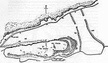
The hill is the site of the Iron Age hillfort Worlebury Camp.[2][3]
Many of Weston-super-Mare's large Victorian residences are built on the lower slopes of the southern side of the hill, but the rest of the hill is heavily wooded. There are ancient fortifications at the top of the hill. Quarrying took place at various places on the hill from the late 18th century until the town quarry was abandoned in 1953.[4] Before the flatlands were adequately drained, the main route to Bristol ran eastwards along the hillside.
Weston Woods
.jpg)
Weston Woods, which cover a large part of the hill top, were awarded a Planting Places Award in a scheme run by Sustainability South West to celebrate "brilliant examples of urban greenspaces" on 6 March 2008.[5] The woods are a 129.56 hectares (320.1 acres) local nature reserve.[6] The woodland provides a habitat for mammals including deer, badgers, foxes and bats. Birds include woodpeckers, buzzards and treecreepers.[7]
References
- ↑ Mark Jackson. "P100m HILLS of ENGLAND, Region 41 South Central England, Section 41A Hills of Somerset". peaklist.org. Retrieved 24 March 2010.
- ↑ "Worlebury Camp". Megalithic Portal. Retrieved 24 January 2010.
- ↑ "Worlebury Camp". Roman Britain .org. Retrieved 5 October 2010.
- ↑ "SOUTH WEST RDA FUND RESTORATION OF WESTON QUARRY". South West RDA. 15 August 2001. Retrieved 2008-02-08.
- ↑ Planting Places Awards
- ↑ "Weston Woods". Natural England. Retrieved 26 August 2015.
- ↑ "Weston Woods Local Nature Reserve, Near Weston super Mare". Avon Local Nature Reserves. Retrieved 26 August 2015.