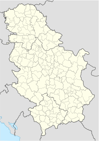
List of World Heritage Sites in Serbia
The United Nations Educational, Scientific and Cultural Organization (UNESCO) World Heritage Sites are places of importance to cultural or natural heritage as described in the UNESCO World Heritage Convention.
Serbia, following its status successed the convention on Tuesday, September 11, 2001, making its historical sites eligible for inclusion on the list. Serbia had its first sites included in 1979, and since 2007, has 5 sites on the list. Of those 5 sites, all 5 are cultural, and Medieval Monuments in Kosovo are traditionally shown as four separate sites, and Stari Ras and Sopoćani as two separate sites also.
In 2002, 5 of 10 properties were submitted, and in 2010, the rest, of the Tentative List.
World Heritage List
| Image | Name | Location | Type (criteria) | Description | Date | Number |
|---|---|---|---|---|---|---|
| | ||||||
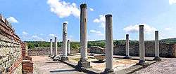 |
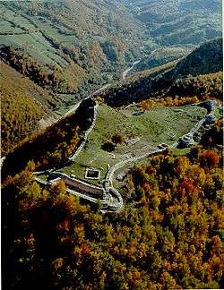
Palace of Galerius |
Zaječar | III, IV | The Late Roman fortified palace compound and memorial complex of Gamzigrad-Romuliana, Palace of Galerius, in the east of Serbia, was commissioned by Emperor Caius Valerius Galerius Maximianus, in the late 3rd and early 4th centuries. It was known as Felix Romuliana, named after the emperor's mother. The site consists of fortifications, the palace in the north-western part of the complex, basilicas, temples, hot baths, memorial complex, and a tetrapylon. The group of buildings is also unique in its intertwining of ceremonial and memorial functions. | 2007 | 1253 |
 |
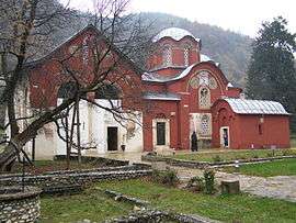
Dečani Monastery |
Peć | II, III, IV | The four edifices of the site reflect the high points of the Byzantine-Romanesque ecclesiastical culture, with its distinct style of wall painting, which developed in the Balkans between the 13th and 17th centuries. The Dečani Monastery was built in the mid-14th century for the Serbian king Stefan Dečanski and is also his mausoleum. The Patriarchate of Peć Monastery is a group of four domed churches featuring series of wall paintings. The 13th-century frescoes of the Church of Holy Apostles are painted in a unique, monumental style. Early 14th-century frescoes in the church of the Holy Virgin of Ljevisa represent the appearance of the new so-called Palaiologian Renaissance style, combining the influences of the eastern Orthodox Byzantine and the Western Romanesque traditions. The style played a decisive role in subsequent Balkan art. (Part of World Heritage in Danger - cause: "Lack of legal protection and management, political instability and security".[1] |
2004 | 724 |
 |
Patriarchate of Peć Monastery | |||||
 |
Our Lady of Ljeviš |
Prizren | ||||
 |
Gračanica Monastery |
Gračanica | ||||
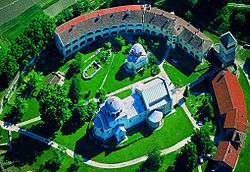 |
|
Kraljevo | I, II, IV, VI | The Studenica Monastery was established in the late 12th century by Stefan Nemanja, founder of the medieval Serb state, shortly after his abdication. It is the largest and richest of Serbia's Orthodox monasteries. Its two principal monuments, the Church of the Virgin and the Church of the King, both built of white marble, enshrine priceless collections of 13th- and 14th-century Byzantine painting. | 1986 | 389 |
 |
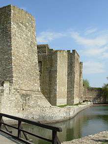
Stari Ras |
Raška | I, III | On the outskirts of Stari Ras, the first capital of Serbia, there is an impressive group of medieval monuments consisting of fortresses, churches and monasteries. The monastery at Sopoćani is a reminder of the contacts between Western civilization and the Byzantine world. | 1979 | 96 |
 |
Sopoćani | |||||
 |
Stećci Medieval Tombstones Graveyards | Perućac, Rastište, Hrta | III, VI | Stećak or the medieval tombstones are the monolith stone monuments found in the regions of the present Bosnia and Herzegovina, parts of Serbia, Montenegro and Croatia. The available sources suggest that they appear from the second half of the 12th century, then last through the 13th century and are intensively made and decorated in the 14th and 15th centuries. But in the 16th century they completely cease. Out of 70,000 recorded tombstones from about 3,300 sites, some 60,000 are in Bosnia and Herzegovina, about 4,400 in Croatia, about 3,500 in Montenegro and some 4,100 in Serbia. The elementary tombstone groups are the laid and the upright stone monoliths. | 2016 | |
Tentative List
The following 11 sites are on the Tentative List for Serbia, meaning that the government intends to consider them for nomination in the future:[2]
| Image | Name | Location | Description | Submitted |
|---|---|---|---|---|
 |
Caričin Grad (Justiniana Prima) | Near Leskovac | The fortified settlement at Caričin Grad is located in south-east Serbia, on the slopes of Mount Radan, descending towards the Leskovac valley, away from any major roads, in the Pusta Reka valley. The first archaeological excavations of Caričin Grad began in 1912 and have been going on to the present day. Based upon the obtained results and historic sources, the first theories about the name of the settlement and the period of its existence have been made. It has been established that it is a town of Iustiniana Prima, built by the Byzantine emperor Justinian I (527-565) near the place he has been born. By the order of the emperor a new administrative and archbishopric seat of the Illyricum province was built, so as to strengthen the rule of Byzantium and help spread Christianity. The settlement was not to last long, and its disappearance is associated with the emperor Heraclius (610-641) and the invasions of Slavic tribes.
|
2002 |
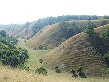
 |
Đerdap National Park | On Danube, near Donji Milanovac | The Djerdap National Park embraces part of the area of the Djerdap Canyon known as the Iron Gates in the central part of the Danube river course,and is divided by the international border running along the middle of the river into the southern - Yugoslav and the northern - Rumanian part. The total area of the National Park is 63.600 ha and the protection zone consists of another 93.968 ha.The morphological characteristics of the region which are the main source of attraction and constitute a natural phenomenon are determined by the 150 km (93 mi). long Djerdap canyon forged by the Danube - the second largest river in Europe which flows through or forms the natural frontier of eight states. The morphological variety of the region is enhanced by the existence of a large number of gorge-like valleys formed by the Danube's tributaries, karst reliefs on limestone plateaus and other phenomena. The geological history of this region is complex and interesting. There are locations where the succession of various geological periods over a span of tens of millions of years can clearly be traced.The Djerdap Canyon is the longest fissure in Europe and a rare natural phenomenon. There are sections where the vertical cliffs rise 300m above the level of the Danube and the measured depth of the so-called "cauldrons" goes up to 82 m. Thanks to the sheltered position of the Iron Gates more than 60 forest and shrub communities heve been preserved many of which are relics of previous, tertiary forest communities. Numerous plant varieties can be found including tertiary relicts and species whose range in Europe has been significantly reduced. More than 1500 plant varieties have been re~ stered in the Djerdap region which confirms its enormous significance in the taxonomic and ecological sense. It is important to note the presence of Corylus colurna, Acer intermedium, Celtis australis, Ilex aquifolium, ceterach officinarum, etc. Rare animal and bind species can also be found in the National Park including bear, lynx, wolf, jackal, gray eagle, short-eored owl, black stork etc. Testifyins to the importance of the Iron Gates section of the Danube in the past are traces of mants presence and the development of his material and spiritual culture from earliest times to the present. The three oldest archaeological localities i.e. Vlasac, Padina and, certainly the most significant internationally, Lepenski Vir, were formed and developed from 7000 - 5000 B.C. Lepenski Vir was the permanent abode of hunters and the religious and artistic centre to which the "first monumental works of art of Central and South-Eastern Europe can be traced as well as the oldest forms of organized social, economic and religious life in the Danube river basin". The discovery of this site marked a new chapter in the study of European pre-history. Lepenski Vir is an impressive illustration of the link between man and nature, of the role and significance of the natural environment for husbandry and the organization of life and culture in general. The Roman Emperors Tiberios, Claudius, Domitian and Trajan cut a strategic road through the Djerdap Canyon and built bridges and fortifications along it in the period of 1st-2nd century A.D. remains of which still stand. The medieval fortresses which defended the entrance into and passage through the Canyon, the most important of which are Golubac and Fetislam from the Turkish period, also testify to constant clashes of various cultures and civilizations in these parts.In the early Middle Ages this region belonged to Byzantium ,then came Slav settlers, it was conquered by Bulgarian tribes and it changed hands repeatedly between the Hungars, Serbs and Turks. In spite of such a turbulent history, picturesque folk customs and traditional village life have been preserved as evidence of uninterrupted life in this region from pagan times to the present day Criteria: VII, X (Natural) |
2002 |
 |
Fortified Manasija Monastery | Despotovac | Manasija Monastery is located in the Resava river gorge, about 135 km (84 mi) south-east of Belgrade. As an endowment of Despot Stefan Lazarević, the monastery was built in the hard times after the Battle at Kosovo (1389) and its construction lasted from 1406/7 to 1418. Its special feature is its fortification, capable of defending and protecting the monastery settlement. Criteria: I, II, IV, VI (Cultural) |
2010 |
 |
Historical place of Bač and its Surroundings | Bač | On the borders of the Pannonia plain and Danube regions, in the Vojvodina Province, there is the town of Bač which lent its name to the whole region between the Danube and Tisa rivers - Bačka. The flatlands bordered by rivers were once a marshy land with ponds and forests, but with time, man was starting to win battles with water, balancing the ratio between land and water. The area around Bač, with the Mostonga river meanders and its confluence with the Danube, testifies to the geomorphologic changes of the terrain, as well as on how it used to look in the distant past, before the waters started to be regulated and the land irrigated. All around Bač there are forests, ponds and marshes, listed as special natural reservations, with their specific forest ecosystems, habitats to natural rarities and to the globally endangered species. There are also archaeological sites, confirming the presence of man and the use of the marshy lands throughout the millennia. The preserved architectural heritage, built in the vast period from the 12th to the 19th century, under the influence of Romanesque, Gothic, Renaissance, Byzantine and Islamic art and the baroque represent a definite testimony to the cultural diversity, interlacing and linking the cultures of the Balkans with the West. Criteria: IV, V, VI, IX (Mixed) |
2010 |
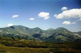 |
Šar Mountains National Park | Štrpce | Biogeographically and ecologically, the Sara National Park represents one of the most important protected areas in the C. Balkans. More than 1500 vascular plant species, of which about 20% are endemic and relict Balkan species, are distributed in the Sara National Park. Vegetation and ecosystems are highly diversified; from sub-Mediterranean communities at the foothill of the mountain to the subalpine forests of endemic Balkan pine (Pinus heldfreichii and P. peuce) up to the highest mountain summits covered by various shrubby and grassland communities on siliceous, limestone and serpentine bedrock. Fauna also, especially ornithofauna, is the richest in numerous rare bird. on the whole Balkan peninsula. Biogeographical coordinates: Mt Sara belongs to the transitional zone between the Meaian, east Illyrian and Scardo-Pindian subregions of the Central European region. The high parts of the massif have transitional characteristics of the Alpine and oro-Mediterranean regions. Criteria: VII, X (Natural) |
2002 |
 |
Negotin breweries | Negotin | In the area of the Negotin Frontier, famous for its vineyards dating from the ancient times, the village population, living off viticulture, used to establish secondary settlements - compounds not far from their permanent homes. The settlements were named after the wine cellars called "pivnice" in this region. These cellars were used to process grapes into wine and brandy, as well as storage facilities. Out of the many settlements located to the north-west and south from Negotin only a few remained: the Rajačke, Rogljevske (Rogljevačke), Štubičke and parts of Smedovačke, Trnjanske, Sikolske and Bratujevačke. The rest of them, such as Badnjevske, Rečanske, Mokranjske and many others no longer exist. Criteria: III, IV, V, VI (Cultural) |
2010 |
 |
Smederevo Fortress | Smederevo | Smederevo Fortress is the last great creation of the Serbian military construction, and one of the largest foritifications in the south-east Europe. It was built with great efforts in order to replace already lost Belgrade, which in 1427, after the death of Despot Stefan Lazarević it was handed over to the Hungarians. As a new centre of Serbia and a Despot Ðurađ Branković's court, an uninhabited place on the confluence of the Jezava and the Danube rivers was chosen, which conditioned a triangular shape of the fortress ground plan. Unlike Belgrade, the new Smederevo Fortress covers a somewhat smaller defence area, with a simpler interior arrangement. During the first stage, between 1428 and 1430, a castle was erected with the ruler's court, originally designed as an independent fortification. Soon after that, in the 1440's, the ramparts were built around the area between the Jezava and the Danube rivers, covering an area of about 10ha, meant for an urban settlement. Criteria: IV, V, (Cultural) |
2010 |
 |
The Deliblato Sands Special Natural Reserve | Banat | The Deliblato Sands is a geo-morphological formation of eolian origin, of exceptional specific beauty and multiple scientific importance. It is of diluvial origin. It is an isolated complex of sand masses with a distinctly undulating dune relief on an area of over 380 sq. kilometres, of elongated ellipsoid shape, surrounded by the expanses of the cultured steppe of the Pannonian plain. The dunes of yellow and gray sand with maximum elevations of around 200 metres above sea level (Pluc - 192 m; Crni vrh - 189 m.) stretch in a straight southesst-northwest direction like the whole complex of the Sands.The physical properties of the sand and soil are behind this areats specific hydrology and meso-climate. There are no sueface watercourses and the only hydrological facilities are dug and drillad wells (some thirty of them), from 150-400 metres deep, and three permanent natural waterholes in smaller depressions in the south-eastern part. The masses of the windblown sand of what used to be the "European Sahara" are today mainly tied down by vegetation, restored by man in planned fashion during the past 170 years. About 16,000 ha is under forest - mainly cultivated pure stands of Scotch and black pine, black locust, poplar,etc., and somewhat less under mixed stands of linden, English and pubescent oak, poplar, flowering ash, and other species. In addition to the anthropogenic forests, in the Deliblato Sands there are smaller preserved remains of one time autochthonous forests of English oak with linden and Lily-of-the-valley (Convalaria majalis).The specific and extreme ecological conditions of these habitats. Criteria: VIII, IX, X (Natural) |
2002 |
 |
Đavolja Varoš | Kuršumlija | The Djavolja Varos natural landmark is situatod on the south slopes of Mt. Radan, on the right bank of the tuta reka (Yellow river), in the central part of esstern Yugoslavia.Djavolja varos is a unique example of the action of erosion. It is a complex of stone pyramids located in the watershed between Djavolja jaruga and Paklena jaruga (Devil's Gully and Hellts Gully). On an area of 4,300 sq.m. water erosion has shaped andesite material and volcanic tuff into over 200 pyramids - towers standing from 2 -15 m. tall, width at base 4 to 6 m. and at the summit 1 - 2 m. Most of these pyramids have caps or heads - andesite blocks protecting them from fast decey. The absolute height of the locality is 700-720 m. Stone pyramids are ephemeral forms, for they disintegrate relatively quickly (when they lose their protective "cap"), and are formed equally quickly through water erosion. Hence the name Djavolja Varos (Devil's Town), because the locals believe that these changes occur as devils fight each other for power. These pyramids came into existence by water erosion, in heterogeneous material; the more massive block on the surface prevented the material beneath it from being destroyed and eroded away, resulting in the formation of the "towers" - pyramids. Two hydrological phenomena characterize the locality: one known as Devil's Water ( a highly mineralized spring, the water of which is used in traditional medicine), and another called the Devil's Well (a pressurized spring). The water is of a markedly red colour, while the area surrounding this natural phenomenon, the soil and the rocks, as well as the pyramids themselves, are of different colours giving a bizarre appearance to the entire scenery. This miraculous worid also features acoustic phenomena which justity the designation "Devil's Town": the wind which hums between the pyramids crestes strange murmurs, howling, sighs, squeaking, which has frightened the local population for centuries and is behind their superstitious lore. The remains of two old churches stand in the vicinity of this natural sculpture; the rich tradition and folk customs of this region are closely associated with this natural phenomenon. Throughout the centuries this area has seen an intertwining of natural phenomena and the life of man. Criteria: VII (Natural) |
2002 |
 |
The Tara National Park with the Drina River Canyon | Bajina Bašta | The Tara National Park is in the westernmost part of Serbia and represents a mountainous area with exceptionally important geo-eorphological, hydrographic and ecological natural values.The total area of the National Park is 19,200 ha with a protective zone of 37,584 ha. The Tara National Park comprises the mountainous region located in a large elbow shaped curve of the Drina river formed by this river in the central section of its course. In morphological terms, the area of the National Park comprises a group of mountain elevations ( highest elevations about 1600 m.) and sharp relief intersected by deep cut river canyons. Among them the most prominent is the canyon of the Drina river which marks the Park' s north and northwast borders. Towering limestone walls, tn places over 1500 metres high, form its valley. Much of the area is composed of carbonaceous rocks and abounds in karst morphology and hydrography (sink holes, smaller hollows, pits and caves, dry karst valleys and springs). What makes the Tara National Park especially valuable is the fact that this area is a mountain refugium where relict Tertiary flora and vegetation with complex forest phytocoenoses in which ende~ics and relicts doninate have been preserved to date. Habitat conditions on Tara have not significantly changed since the Tertiary to date. As the glacial and interglacial epochs went by, the climatic extremes in the Balkans were -to a large extent mitigated by a section of the large Paratethys - the Pannonian ssa, an arm of which penetrated as far as Mt. Tara via what today is the Drina river valley. Relict habitats on Tara, especially the gorges of the Derventa and Brusnica rivers as well as the Drina river canyon, were a refugium with variegated and diversified Tertiary vegetation. Thirty-five forest communities have been identified, of which four are relicts and were more widespread in the Tertiary era. It is important to point out that over 60% of the territory of the Tara National Park are well-preserved forest complexes of spruce, fir, beech or pine. Parts of these forests rank as the best preserved and highest quality forest complexes in Europe. The greatest value of Mt.Tara and of entire Europe is the conifer species Pancicts spruce ( Picea omorica Panc.), which has, since its discovecy in 1876, provoked grest interest in scientific cincles. The spruce is a relict species originating in the Tertiary when it was broadcast across extensive ranges in Europe and parts of Asia. Having survived glaciation, this species receded and at present covers only a small narrow strip in the region of the central flow of the Drina river, in the Balkan peninsula and Europe. In this sense the spruce is an endemic, with a very narrow range. Issues which have still not been clarified in connoction with this species are the question of its origin and the reasons of its confinement to such a saall range , as well as whether it is becoming biologically extinct or is receding under the influence of external factors and man.Conifers related to this spruce which appear in North America and Eastern Asia belong to other species. This spruce is considered the most beautiful conifer of Europe. In addition to Pancicts spruce, Tara also bossts Taxus baccata, Ilex aquifolium, Dafne blagoyana, species endangered in most of Europe.We shouid also point out that Pancic's spruce on Tara is also encountered on a unique peat habitat which is a phenomenon as yet unrecorded for an endemo-relict species. The fauna of this region comprises a large number of species of which some are endangered: bear (Ursus arctos) chamois (Rupicapra rupicapra) golden eagle (Aquila chryssetos),etc. It is assumed that before the Slavs came to this area the first inhabitants of the Balkan peninsula were Illyrian tribes while the Romans were not particularly interested in settling this region. There are some material remains in archaeological sites dating back to this period. There are also some medieval finds from 14th and 15th centuries as well as from the period of Turkish rule. Criteria: X (Natural) |
2002 |
See also
References
- ↑ "Medieval Monuments in Kosovo". UNESCO. Retrieved 3 Dec 2010.
- ↑ "Tentative Lists: Serbia". UNESCO. Retrieved 11 May 2010.
External links
- Serbia - UNESCO World Heritage Centre
- UNESCO World Heritage Sites - Official site
- UNESCO World Heritage Centre - Official site
Serbia articles | |||||||||||||
|---|---|---|---|---|---|---|---|---|---|---|---|---|---|
| History |  | ||||||||||||
| Geography | |||||||||||||
| Politics |
| ||||||||||||
| Economy | |||||||||||||
| Society |
| ||||||||||||
| |||||||||||||
| |||