Woodrow, Saskatchewan
For other uses, see Woodrow.
| Woodrow | |
|---|---|
| Unincorporated community | |
|
Woodrow grain elevators | |
  Location of Woodrow in Saskatchewan | |
| Coordinates: 49°41′42″N 106°43′23″W / 49.695°N 106.723°W | |
| Country | Canada |
| Province | Saskatchewan |
| Region | Saskatchewan |
| Census division | 3 |
| Rural Municipality | RM of Wood River |
| Post office Founded | 1909-06-01 |
| Incorporated (Village) | N/A |
| Dissolved | March 21, 2002 |
| Government | |
| • Governing body | RM of Wood River |
| Area | |
| • Total | 0.42 km2 (0.16 sq mi) |
| Population (2006) | |
| • Total | 5 |
| • Density | 11.9/km2 (31/sq mi) |
| Time zone | CST |
| Postal code | S0H 4M0 |
| Area code(s) | 306 |
| Highways |
Highway 13 Highway 610 |
| Waterways | Thomson Lake |
| [1][2][3][4] | |
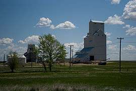
Woodrow is an unincorporated community in the Canadian province of Saskatchewan approximately 6 miles west of Lafleche. This present day agricultural area was once the hub of the local area with lumber yards, grain elevators, 3 churches and 3 or more general stores. The village was formally dissolved on March 21, 2002; it is now administered by the RM of Wood River.[5]
Demographics
| Canada census – Woodrow, Saskatchewan community profile | |||
|---|---|---|---|
| 2006 | |||
| Population: | 5 (-66.7% from 2001) | ||
| Land area: | 0.42 km2 (0.16 sq mi) | ||
| Population density: | 11.9/km2 (31/sq mi) | ||
| Median age: | NA (M: NA, F: NA) | ||
| Total private dwellings: | 11 | ||
| Median household income: | $NA | ||
| References: 2006[6] | |||
Infrastructure
Transportation
Saskatchewan Transportation Company provides intercity bus service.[7]
Churches
The Woodrow Gospel Chapel began service in 1909, and was based on immigrants from North Dakota when the community was originally known as Hoffnungsfeld.[8]
See also
References
- ↑ National Archives, Archivia Net, Post Offices and Postmasters
- ↑ Government of Saskatchewan, MRD Home, Municipal Directory System, archived from the original (– Scholar search) on November 21, 2008
- ↑ Canadian Textiles Institute. (2005), CTI Determine your provincial constituency
- ↑ Commissioner of Canada Elections, Chief Electoral Officer of Canada (2005), Elections Canada On-line
- ↑ "Restructured Villages". Saskatchewan Ministry of Municipal Affairs. Retrieved 2010-12-20.
- ↑ "2006 Community Profiles". Canada 2006 Census. Statistics Canada. March 30, 2011. Retrieved 2009-02-24.
- ↑ "Saskatchewan Transportation Company: Route Map" (PDF). Saskatchewan Transportation Company. Retrieved 2010-12-20.
- ↑ "Woodrow Gospel Chapel". Global Anabaptist Mennonite Encyclopedia Online. Retrieved 2010-12-20.
External links
- Saskatchewan City & Town Maps
- Saskatchewan Gen Web - One Room School Project
- Post Offices and Postmasters - ArchiviaNet - Library and Archives Canada
- Saskatchewan Gen Web Region
- Online Historical Map Digitization Project
- GeoNames Query
- 2006 Community Profiles
 |
Bateman | Thomson Lake | | |
| Meyronne | |
Lafleche | ||
| ||||
| | ||||
| Glentworth |
| Subdivisions | |
|---|---|
| Communities | |
| Cities | |
| Topics |
|
| |
Coordinates: 49°41′42″N 106°43′23″W / 49.695°N 106.723°W
This article is issued from Wikipedia - version of the 9/10/2016. The text is available under the Creative Commons Attribution/Share Alike but additional terms may apply for the media files.