Woodlawn, Fairfax County, Virginia
| Woodlawn, Fairfax County, Virginia | |
|---|---|
| Census-designated place | |
|
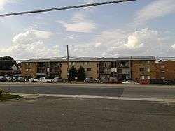
Apartment complex in Woodlawn, typical of those found locally in the Route 1 corridor | |
 Woodlawn  Woodlawn  Woodlawn | |
| Coordinates: 38°43′59″N 77°6′54″W / 38.73306°N 77.11500°WCoordinates: 38°43′59″N 77°6′54″W / 38.73306°N 77.11500°W | |
| Country | United States |
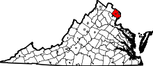
| State | Virginia |
| County | Fairfax |
| Area | |
| • Total | 2.31 sq mi (5.98 km2) |
| • Land | 2.30 sq mi (5.95 km2) |
| • Water | 0.01 sq mi (0.03 km2) |
| Elevation | 30 ft (9 m) |
| Population (2010) | |
| • Total | 20,804 |
| • Density | 9,051/sq mi (3,494.8/km2) |
| Time zone | Eastern (EST) (UTC-5) |
| • Summer (DST) | EDT (UTC-4) |
| ZIP code | 22309 |
| FIPS code | 51-87430 |
| GNIS feature ID | 2584939 |
Woodlawn is a census-designated place in Fairfax County, Virginia, United States. The population as of the 2010 census was 20,804.[1] It consists of that part of Mount Vernon CDP which, up to the 2000 census, was north of U.S. Route 1, i.e. the area between Fort Belvoir to the west and Little Hunting Creek to the east, and south of Huntley Meadows Park. Historic Woodlawn Plantation is at the west end of it.
References
- ↑ "Geographic Identifiers: 2010 Demographic Profile Data (G001): Woodlawn CDP (Fairfax County), Virginia". U.S. Census Bureau, American Factfinder. Retrieved October 18, 2016.
This article is issued from Wikipedia - version of the 10/27/2016. The text is available under the Creative Commons Attribution/Share Alike but additional terms may apply for the media files.