Wittmann, Arizona
| Wittmann, Arizona | |
|---|---|
| Census-designated place | |
|
Wittmann Fire Station at Pattton Road | |
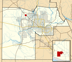 Location in Maricopa County and the state of Arizona | |
 Wittmann, Arizona Location in the United States | |
| Coordinates: 33°46′35″N 112°31′43″W / 33.77639°N 112.52861°WCoordinates: 33°46′35″N 112°31′43″W / 33.77639°N 112.52861°W | |
| Country | United States |
| State | Arizona |
| County | Maricopa |
| Population (2010) | |
| • Total | 6,700 |
| Time zone | Mountain (MST) (UTC-7) |
| ZIP codes | 85361 |
| Area code(s) | 623 |

Wittmann is a census-designated place in Maricopa County, Arizona, United States. It is located along U.S. Route 60 in the central part of Arizona, about 35 miles northwest of central Phoenix, and while technically located within the city's metropolitan area it is generally regarded by locals to be just outside it. As of the 2010 census, there were 6700 people living in the Wittmann area (Zip Code 85361).
A variant name was Nadaburg; the present name is for one Mr. Whittmann, an official who was credited with the construction of a nearby dam.[1]
Demographics
As of the census[2] of 2010, there were 6700 people residing in the Wittmann area (Zip Code 85361). The population density was 56.3 people per square mile. The racial makeup of Wittmann was 83.8% White, 0.8% Black or African American, 1.2% Native American, 0.5% Asian, 0.1% Pacific Islander, 10.6% from other races, and 3.0% from two or more races. 24.0% of the population were Hispanic or Latino of any race.
Municipalities and communities of Maricopa County, Arizona, United States | ||
|---|---|---|
| Cities |  | |
| Towns | ||
| CDPs | ||
| Unincorporated communities |
| |
| Indian reservations | ||
| Ghost towns | ||
| Footnotes | ‡This populated place also has portions in an adjacent county or counties | |
References
- ↑ U.S. Geological Survey Geographic Names Information System: Wittmann, Arizona
- ↑ [http://factfinder.census.gov/bkmk/cf/1.0/en/zip/85361/POPULATION/DECENNIAL_CNT