Wittenham Clumps

Wittenham Clumps is the common name for a pair of wooded chalk hills in the Thames Valley, in the civil parish of Little Wittenham in Oxfordshire (part of Berkshire until 1974).
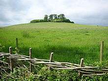
The higher of the two, Round Hill, is 390 feet (120 m) above sea-level. The 350 feet (110 m) Castle Hill is about 380 yards (350 m) south-east and was the site of an Iron Age hill fort.[1] A third hill, not normally considered one of The Clumps, is Brightwell Barrow, further to the south-east.
The grassed slopes of The Clumps lead up to summits wooded by the oldest beech tree plantings in England,[2] dating to the 1740s.[3] Standing over 70 metres above their surroundings,[4] the Clumps have a prominent appearance and panoramic views, with the north slopes overlooking villages and towns whose sites mark some of the first settlements of the English.[5] The view from The Clumps was described by the artist Paul Nash, who first saw them in 1911, as "a beautiful legendary country haunted by old gods long forgotten".[6]
The Clumps are the most visited outdoor site in Oxfordshire, attracting over 200,000 visitors a year.[7] A car park was added in 1971, and the extensive network of paths are accessible by foot all year round. A path through the wooded area at the top of Round Hill has enabled access since 2005, after being closed for twenty years. The site and its surroundings are maintained as a Nature Reserve by the Earth Trust.[8]
Toponomy


Strictly speaking, the name Wittenham Clumps refers to the wooded summits of these hills, which are themselves more properly referred to as the Sinodun Hills, the name Sinodun deriving from Celtic, Seno-Dunum, meaning 'Old Fort'.[9] Alternatively, it has been suggested that the name is a scholarly creation, punning on the Latin 'sinus' (bosom).[10] Other lesser-used and more colloquial names for the Clumps include the Berkshire Bubs (since the Clumps were formerly in the county of Berkshire – the boundary was redrawn in 1974) and Mother Dunch's Buttocks (after a local Lady of the Manor named Dunch).
On Sinodun Hill is a hollow named the Money-Pit and a clump of trees named the Cuckoo Pen. The Money-Pit is supposedly the location of a treasure hoard guarded by a raven, and the Cuckoo Pen gets its name from the local belief that a trapped cuckoo would ensure eternal Summer.[11]
Location
Wittenham Clumps are located at grid reference SU569925, close to the River Thames, and good views can be had from the Thames Path along the river. The panoramic views of the Oxfordshire countryside from the Clumps themselves are also spectacular; a viewpoint guide on the north side of Round Hill gives directions to many sights, the furthest being Faringdon Folly, a tower built on another Iron Age hillfort 27 km to the west. Day's Lock and Dorchester Abbey are clearly visible in the valley to the north, with the 15-storey Plowman Tower in Northway, Oxford visible on the horizon, 14 km away. The white-walled reactor buildings of the Joint European Torus, site of the world's first successful controlled nuclear fusion experiments, can be seen around 6 km to the north-west. The three remaining 110m high cooling towers of Didcot Power Station, constructed in the late 1960s, dominate the skyline to the west; three others were demolished on 27 July 2014. To the north-east is Little Wittenham Wood, which borders the Thames, and to the south-east is Brightwell Barrow.
The wooded area at the top of Castle Hill, which contains a public footpath, is now closed indefinitely due to the danger of falling trees. The entrance to the wooded area atop Round Hill also carries a warning of falling branches due to fungal decay of many of its trees.
Archaeology
There is a hillfort on Castle Hill. The earliest earthworks date to the late Bronze Age. More banks and ditches were added during the early Iron Age. Excavation has revealed that the Iron Age inhabitants caught fish and wild boar as well as herding cattle and sheep. There is also evidence of cultivation of barley and wheat. The fort appears to have been abandoned by the late Iron Age, the next occupants being Romans. A 2004 episode of the Channel 4 archaeological television programme Time Team focused on the Clumps.[12] In 2004 Castle Hill was under excavation by Oxford Archaeology, and Time Team was charged with investigating the surrounding landscape to find any trace of activity that could be associated with the Clumps.
Over a period of three days, Time Team surveyed a total of seven hectares using ground-penetrating radar. The original focus was the previously unexplored Round Hill, but difficulties in carrying out geophysical studies on its tree-covered crest forced the team to abandon their original goal. Moving down the southern slopes, however, many hidden features emerged, including enclosure ditches, pits, possible buildings and other clusters of anomalies. The geophysics highlighted a large rectilinear enclosure, which was subsequently singled out for excavation. This revealed the remains of a Romano-British house with tesserae (mosaic) floors and painted wall plaster on the southern slope of Round Hill. The area also contained an Iron-Age cobbled floor, together with post holes that could have related to a structure.
Further investigations found Iron Age rubbish pits distributed all over the valley, suggesting widespread settlement throughout the period. Pottery finds indicated that most activity took place in the earlier and later phases of the period, with a quieter occupation phase in the middle. The geophysics surveys also uncovered more suspected Iron Age enclosures along with what appeared to be a Roman road, which would have been associated with the site.

The overall chronology suggested by the excavations is of the site being occupied since the Bronze Age around 1000 BC, the hillfort and surrounding farms dating from around 600 BC, followed by a move down towards the southern part of the site around 300 BC. The area was then abandoned, until the construction of the Roman villa.
Among the many artefacts found in the area are an oval bronze shield around 35 cm in diameter, retrieved from the nearby river Isis in 1836[13] and the 70 cm long Wittenham Sword and scabbard, found in 1982 and dating from the Late Iron Age (120 BC - AD 43)[14][15]
Poetry
The eastern side of Castle Hill is the location of the Victorian 'Poem Tree',[16] a beech tree which had a poem carved into it by Joseph Tubb of Warborough Green in 1844–45.[17] The tree, which died in the 1990s, collapsed in 2012; there is now a stone commemorating the 150th anniversary of the carving.
Wittenham Clumps is said to be where Matthew Prior wrote Henry and Emma,[18] and this is commemorated by a plaque.
Usage in media
Wittenham Clumps were repeatedly painted by the 20th-century British artist Paul Nash.[19][20][21][22][23]
The Clumps was the filming location for the Radiohead webcast video of the band's song "Faust Arp".[24][25]
The climax of the third episode of the third season of the Netflix series Black Mirror takes place in the woods.
References
- ↑ Round Hill, Wittenham Clumps, Oxfordshire: Archaeological Evaluation and Assessment of Results, Wessex Archaeology report 52568.09 (March 2004)
- ↑ "Paul Nash and The Wittenham Clumps". nashclumps.org.
- ↑ Paul Brears. "Oxford Conservation Volunteers : Nature Reserves". ocv.org.uk.
- ↑ "Walk - Dorchester-on-Thames - Wittenham Clumps - 4.5 Miles". Meetup.
- ↑ Clark, O A, Clark A Seeing Beneath the Soil: Prospecting Methods in Archaeology 1997 (Routledge) p11
- ↑ "The Early Works of Paul Nash". nashclumps.org.
- ↑ "Plans outlined for Wittenham Clumps reserve". Oxford Mail.
- ↑ Wittenham Clumps trust re-named Witney Gazette 7 March 2011
- ↑ "Royal County of Berkshire History Home Page". berkshirehistory.com.
- ↑ Coates, R. (2000), The Sinodun Hills, Little Wittenham, Berkshire, Journal of the English Place Name Society, vol. 32, pgs 23–25
- ↑ "RBH: History of Little Wittenham, Berkshire (Oxfordshire)". Nash Ford Publishing. 2004. Retrieved 15 July 2014.
- ↑ "Time Team Wittenham Clumps". Retrieved 5 February 2011.
- ↑ "Archaeologia - XX. A Letter from John Gage, Esq. F.R.S., Director, to Sir Henry Ellis, K.H., F.R.S., Secretary, with an Account of a British Buckler, found in the bed of the River Isis, between Little Wittenham and Dorchester, in Oxfordshire". Archaeologia. The Society of Antiquaries of London 1838. 27: 298–300. January 1838. doi:10.1017/S0261340900012145.
- ↑ "Ashmolean Museum: British Archaeology Collections - Wittenham Sword". ox.ac.uk.
- ↑ A G Sherratt A newly-discovered la tene sword and scabbard Oxford Archaeology vol 2 p115 1983
- ↑ The Poem Tree, Royal Berkshire History, UK.
- ↑ Poem Tree, Northmoor Trust.
- ↑ Prior, Matthew, Henry and Emma.
- ↑ "Wittenham Clumps circa 1943–4". Tate Online. Tate Britain, UK. Retrieved 7 June 2011.
- ↑ "Landscape of the Wittenham Clumps, 1936". Paul Nash. British Council, UK. Retrieved 7 June 2011.
- ↑ "Artists and the Landscape: Paul Nash". Arts & Literature. Northmoor Trust, UK. Retrieved 7 June 2011.
- ↑ Baines, Christopher; Dillon, Anna. "Paul Nash and the Wittenham Clumps". The North Wessex Downs Area of Outstanding Natural Beauty, UK. Retrieved 7 June 2011.
- ↑ Landscape of the Moon's Last Phase by Paul Nash, Walker Art Gallery, Liverpool, UK.
- ↑ Listen Against, Ladies & Gentlemen & Radiohead Webcast News, UK.
- ↑ Radiohead video, YouTube.
External links
| Wikimedia Commons has media related to Wittenham Clumps. |
- Earth Trust
- Little Wittenham at Royal Berkshire History
- Photograph, Geograph British Isles project
- Archaeological dig, Time Team, Channel 4
Coordinates: 51°37′42″N 1°10′46″W / 51.62845°N 1.17937°W