Wisconsin Avenue
Wisconsin Avenue is a major thoroughfare in Washington, D.C., and its Maryland suburbs. It starts in Georgetown just north of the Potomac River, at an intersection with K Street under the Whitehurst Freeway. The section of Wisconsin Avenue in Georgetown was called High Street before the street names in Georgetown were changed in 1895 to conform to those of the L'Enfant plan for the federal city (although Georgetown predates the planned capital by half a century).
Route

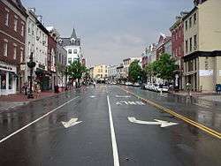
From the Georgetown riverfront, Wisconsin Avenue climbs steeply north through Northwest D.C. (see picture above), through often congested, slow-moving traffic squeezed into just two travel lanes, with parked vehicles continuously filling both curb lanes. The Avenue then passes through the neighborhoods of Glover Park, Cathedral Heights (next to the Washington National Cathedral), Cleveland Park, Tenleytown and Friendship Heights with its several broadcasting towers. While in Friendship Heights, Wisconsin Avenue intersects with Western Avenue (which forms much of the Northwest border of Washington, D.C.) and then crosses into Montgomery County, Maryland. In Maryland, it is officially known as Maryland Route 355. Wisconsin Avenue then passes through Bethesda, where it is one of the main streets of the downtown area. Southbound traffic on Wisconsin Avenue can bypass downtown Bethesda by taking Woodmont Avenue.

Just north of downtown Bethesda, at the intersection with Glenbrook Parkway, its name changes to "Rockville Pike". Rockville Pike runs along the National Institutes of Health campus, the United States National Library of Medicine, and the National Naval Medical Center and has an incomplete interchange with the Capital Beltway at exit 34. The Pike then runs through North Bethesda into Rockville, which is the county seat of Montgomery County. This part of Rockville Pike is home to many strip malls, as well as White Flint Mall, and is notorious for its traffic congestion.
Near the center of Rockville, the name changes to "Hungerford Drive" for a short while. In the outskirts of Rockville, the name changes to "Frederick Road". However, in the city of Gaithersburg, the road is known as South Frederick Avenue south of Diamond Avenue in downtown, and North Frederick Avenue north of Diamond Avenue. Upon leaving Gaithersburg city limits, the name returns to Frederick Road, which continues through the unincorporated communities of Germantown and Clarksburg, both rapidly developing suburbs. Upon entering Frederick County and the unincorporated community of Urbana, the road is known as "Urbana Pike". It ends at U.S. Highway 15, just north of the city of Frederick, which is the county seat. In downtown Frederick, the route is known as "Market Street".
Building numbering
One aspect of Rockville Pike that confuses many motorists is the system of assigning building numbers. In unincorporated areas of the county, building numbers are assigned according to the addressing system in use in Montgomery County, a Cartesian coordinate plane with its origin at the United States Capitol. Within the city limits of Rockville, however, the origin of the numbering system is at the center of Rockville. Thus, someone driving north on the Pike sees building numbers above 12000 and rising, which suddenly give way to building numbers below 2000 and falling.
In Gaithersburg, the numbering direction changes twice. Addresses on South Frederick Avenue increase from zero as one travels south from Diamond Avenue, and only reach the hundreds by the southern city boundary. On North Frederick Avenue, the numbers similarly increase from zero as one travel to the north. As one leaves Gaithersburg to the north, the building numbers change back to the county's Capitol-based system.
Parallel transportation
From the Tenleytown-AU station north, Wisconsin Avenue/Rockville Pike/Route 355 runs approximately parallel to the Red Line of the Washington Metro. North of the Capital Beltway until Frederick (at the Interstate 70 junction), the highway runs parallel to Interstate 270, which handles express traffic through Montgomery and southern Frederick counties.
Transit service
Metrorail
Metrorail stations on or near Wisconsin Avenue are all served by the Red Line. They include:
- Tenleytown-AU
- Friendship Heights
- Bethesda
- Medical Center
- Grosvenor-Strathmore
- White Flint
- Twinbrook
- Rockville
- Shady Grove
Metrobus
The following Metrobus routes travel along the street (listed from south to north):
- 31, 32, 36 (Western Ave. to M St. NW) via the Pennsylvania Avenue Line
- 37 (Limited stop service from Western Ave. to Massachusetts Ave.)
- J7 (I-270 to Bethesda station)
- J2, J3 (Cedar Lane to East-West Highway)
- J9 (I-270 to Woodmont Ave.)
- J1 (Cedar Lane to Jones Bridge Rd.)
- J5 (Nicholson La. to I-495)
- Q2 (Shady Grove station to Veirs Mill Rd.)
DC Circulator
The D.C. Circulator's Georgetown-Union Station route travels along the street:
Ride On
The following Ride On routes travel along the street (listed from south to north):
- 42 (Medical Center station to Western Ave.)
- 34 (Cedar Lane to Woodmont Ave., and later Bethesda station to Western Ave.)
- 33 (Medical Center station to Chestnut Ave., crossing again at Bethesda station)
- 46 (Rockville station to Medical Center station)
- 30 (Pooks Hill Rd. to Medical Center station)
- 6 (Strathmore Ave. to Grosvenor La.)
- 5 (Old Georgetown Rd.—Rockville—to Strathmore Ave.)
- 38 (Montrose Rd. to Nicholson La.)
- 81 (Rockville station to Wootton Pkwy.)
- 45 (College Pkwy. to Rockville station)
- 55 (Shakespeare Blvd. to Travis Ave., and later Odenhal Ave. to Rockville station)
- 59 (Odenhal Ave. to W. Diamond Ave., and later Deer Park Rd. to Shady Grove station)
MARC Train
The following MARC Train stops lie near the street:
Place in the National Highway System
Wisconsin Avenue/Rockville Pike is part of the National Highway System as an arterial route from M Street to the Beltway and as an intermodal connector from the Beltway to the Grosvenor Metro station.
History

Wisconsin Avenue follows the route of an ancient Native American trail. Between 1805 and 1820, it was reconstructed into a toll road to carry tobacco and other products between Georgetown and Frederick. Starting around 1920, various sections of the road have been paved and widened to two, four and as many as six lanes.
In 1864, General Jubal A. Early marched down this road from Monocacy Junction in an attempt to take Washington, D.C. that ended in the Battle of Fort Stevens.
Wisconsin Avenue was once U.S. Highway 240. Outside of the Beltway, U.S. Highway 240 was relocated to what is today Interstate 270. Eventually, the entire route designation was decommissioned.
External links
| Wikimedia Commons has media related to Wisconsin Avenue. |
- Peerless Rockville on Local Transportation
- City of Rockville, Rockville Pike Corridor Neighborhood Plan