Winslow Road railway station
| Winslow Road | |
|---|---|
 | |
| Location | East Claydon |
| Local authority | Aylesbury Vale |
| Grid reference | SP750260 |
| Number of platforms | 2 |
| Railway companies | |
| Original company | Aylesbury and Buckingham Railway |
| Pre-grouping |
Metropolitan Railway Metropolitan and Great Central Joint Railway |
| Key dates | |
| 1868 | Opened |
| 1936 | Closed to local passengers and goods |
| 1947 | Line closed |
| Replaced by | none |
| Other information | |
| Lists of stations | |
|
| |
Winslow Road railway station served the village of East Claydon near Winslow to the north of Quainton in Buckinghamshire, England. It was the second station to serve the town after Winslow on the Varsity Line.
History
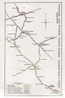
The station was opened by the Aylesbury and Buckingham Railway (A&BR) on 23 September 1868[1][2][3] as part of its 12.75-mile (20.52-kilometre) route from Aylesbury to Verney Junction where it joined the Buckinghamshire Railway's Oxford to Bletchley line.[4][5][6] The line was single track and worked from the start by the Great Western Railway, which provided a service of three trains each way daily.[5][7] The A&BR, which had for some time been in a parlous financial state, was absorbed by the Metropolitan Railway with effect from 1 July 1891.[6][8][9][10] From 2 April 1906, all Metropolitan services north of Harrow South Junction to Verney Junction were run by the Metropolitan and Great Central Joint Railway; this continued until 6 July 1936 when the London Passenger Transport Board, which had taken over the Metropolitan in 1933, withdrew local passenger services as an economy measure.[11][9][8][12] Through services ceased entirely on 7 September 1947 and the route closed.[13][11][9][14]
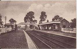
The original A&BR station, which was situated to the north of a level crossing over the East Claydon Road, had a single platform and lightweight flange-bolted flat-bottom rail.[15][16] A small hut and cottage were provided for the gatekeeper who also served as the station's porter; a small signal box controlled access to a siding.[17][16] The station was entirely rebuilt by the Metropolitan Railway which doubled the line and provided a Down platform which partially obstructed the line of sight from the signal box.[18]
Winslow Road saw little passenger traffic,[19] which may be attributed to its location a little over a mile from the village of Winslow which it purported to serve and which had its own conveniently-sited station on the Oxford to Bletchley line since May 1850.[2][20] During 1939, work started on singling the line south of Winslow Road, with the double track left on a section from a pair of stops near the station to Verney Junction.[21] The work was completed by 28 January 1940 and the line south of Winslow Road became effectively a long siding.[21][15] Train crews operated the level crossing gates and all signalling was removed to make the route one section between two junctions.[21] Freight traffic from the Oxford to Bletchley line was rerouted via a connecting spur near Calvert which was brought into use on 14 September 1940, thereby allowing trains to work south over the Great Central Main Line.[22]
After closure, the track was eventually lifted although the northern section of the route between Verney Junction and Winslow Road was retained until 1957 for the storage of condemned rolling stock, with the track finally being removed in 1961.[23][15][21]
| Preceding station | Disused railways | Following station | ||
|---|---|---|---|---|
| Verney Junction Line and station closed |
Metropolitan Railway | Granborough Road Line and station closed | ||
Present day
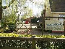
The site of Winslow Road has been reused for dog kennels.[24][19][25] A brick pig sty was constructed between the platforms and this now forms part of the kennels.[26][27] A fragment of the Up platform complete with blue bricks survives to the left of the former pig sty.[27][28]
Due to its association with the Metropolitan line, this station is considered to be one of the Closed London Underground stations although it is over 40 miles (64 kilometres) from London and is not underground.
References
Notes
- ↑ Quick (2009), p. 415.
- 1 2 Butt (1995), p. 252.
- ↑ Davies & Grant (1984), p. 84.
- ↑ Simpson (1985), p. 8.
- 1 2 Oppitz (2000), p. 30.
- 1 2 Simpson (1994), p. 133.
- ↑ Simpson (1985), p. 9.
- 1 2 Awdry (1990), p. 207.
- 1 2 3 Leleux (1984), p. 37.
- ↑ Davies & Grant (1984), p. 85.
- 1 2 Davies & Grant (1984), p. 89.
- ↑ Clinker (1978), p. 149.
- ↑ Mitchell & Smith (2006), fig. 54.
- ↑ Oppitz (2000), p. 38.
- 1 2 3 Simpson (1985), p. 108.
- 1 2 Mitchell & Smith (2006), fig. 52.
- ↑ Simpson (1985), pp. 108, 112.
- ↑ Simpson (1985), p. 107.
- 1 2 Shannon (1996), p. 117.
- ↑ Mitchell & Smith (2006), fig. XIV.
- 1 2 3 4 Grigg (1980), p. 67.
- ↑ Davies & Grant (1984), pp. 89-90.
- ↑ Davies & Grant (1984), p. 91.
- ↑ Davies & Grant (1984), p. 219.
- ↑ Oppitz (2000), p. 39.
- ↑ "Disused Stations". Subterranea Britannica.
- 1 2 Williams, Hywell (31 March 2005). "Metropolitan - from Quainton Road to Verney Junction". Retrieved 2012-08-28.
- ↑ "Aylesbury - Verney Junction (Pt. 2)". Retrieved 2012-08-28.
|first1=missing|last1=in Authors list (help)
Sources
- Awdry, Christopher (1990). Encyclopaedia of British Railway Companies. Sparkford: Patrick Stephens Ltd. ISBN 1-8526-0049-7. OCLC 19514063.
- Butt, R. V. J. (1995). The Directory of Railway Stations: details every public and private passenger station, halt, platform and stopping place, past and present (1st ed.). Sparkford: Patrick Stephens Ltd. ISBN 1-8526-0508-1. OCLC 60251199.
- Clinker, C.R. (October 1978). Clinker's Register of Closed Passenger Stations and Goods Depots in England, Scotland and Wales 1830–1977. Bristol: Avon-Anglia Publications & Services. ISBN 0-905466-19-5. OCLC 5726624.
- Davies, R.; Grant, M.D. (1984) [1975]. Forgotten Railways: Chilterns and Cotswolds. Newton Abbot, Devon: David St John Thomas. ISBN 0-946537-07-0.
- Grigg, A.E. (1980). Town of Trains: Bletchley and the Oxbridge line. Buckingham: Barracuda Books. ISBN 0-86023-115-1.
- Leleux, Robin (1984) [1976]. A Regional History of the Railways of Great Britain: The East Midlands. 9. Newton Abbot, Devon: David St. John Thomas. ISBN 978-0-946537-06-8.
- Oppitz, Leslie (2000). Lost Railways of the Chilterns. Newbury, Berkshire: Countryside Books. ISBN 978-1-84674-108-1.
- Mitchell, Vic; Smith, Keith (November 2006). Aylesbury to Rugby (Midland Main Lines). Midhurst, West Sussex: Middleton Press. ISBN 978-1-904474-91-3.
- Quick, Michael (2009) [2001]. Railway passenger stations in Great Britain: a chronology (4th ed.). Oxford: Railway and Canal Historical Society. ISBN 978-0-901461-57-5. OCLC 612226077.
- Shannon, Paul (1996) [1995]. British Railways Past and Present: Buckinghamshire, Bedfordshire and West Hertfordshire. Wadenhoe, Peterborough: Past & Present Publishing. ISBN 978-1-85895-073-0. No. 24.
- Simpson, Bill (1994) [1978]. Banbury to Verney Junction Branch. Banbury, Oxon: Lamplight Publications. ISBN 978-1-899246-00-7.
- Simpson, Bill (1985). The Brill Tramway including the Railway from Aylesbury to Verney Junction. Poole, Dorset: Oxford Publishing Co. ISBN 0-86093-218-4.
Further reading
- Simpson, Bill (2005). A History of the Metropolitan Railway: From Aylesbury north to Verney Junction and Brill. 3. Banbury, Oxon: Lamplight Publications. ISBN 978-1-899246-13-7.
- Simpson, Bill (2011). Quainton Road Station and other stations in the Vale of Aylesbury. Banbury, Oxon: Lamplight Publications. ISBN 978-1-899246-52-6.
External links
Coordinates: 51°55′40″N 0°54′37″W / 51.9277°N 0.9104°W
| Stations |
| ||||||||||||||||||||||||||
|---|---|---|---|---|---|---|---|---|---|---|---|---|---|---|---|---|---|---|---|---|---|---|---|---|---|---|---|
| Rolling stock |
| ||||||||||||||||||||||||||
| History |
| ||||||||||||||||||||||||||
| Future proposals |
| ||||||||||||||||||||||||||
| |||||||||||||||||||||||||||