Wilsons Promontory
| Wilsons Promontory | |
| Peninsula | |
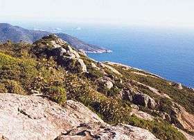 Looking south from Mount Oberon on Wilsons Promontory towards the southern tip of the Australian mainland. | |
| Nickname: The Prom | |
| Country | Australia |
|---|---|
| State | Victoria |
| Region | Gippsland |
| Municipality | South Gippsland Shire |
| Landmark | Wilsons Promontory Lighthouse |
| Rivers | Tidal River, Darby River |
| Coordinates | 39°02′S 146°23′E / 39.033°S 146.383°ECoordinates: 39°02′S 146°23′E / 39.033°S 146.383°E |
| Lowest point | South Point |
| - elevation | 0 m (0 ft) |
| - coordinates | 39°08′06″S 146°22′32″E / 39.13500°S 146.37556°E |
| National parks | |
|
Location of Wilsons Promontory in Victoria | |
| Wikimedia Commons: Wilsons Promontory National Park | |
The Wilsons Promontory[1] is a peninsula that forms the southernmost part of the Australian mainland and is located in the state of Victoria. It is known to the indigenous Gunai/Kurnai and the Boonerwrung Clans as Yiruk and Wammum respectively.[2]
South Point at 39°08′06″S 146°22′32″E / 39.13500°S 146.37556°E is the southernmost tip of Wilsons Promontory and hence of mainland Australia. Located at nearby South East Point, (39°07′S 146°25′E / 39.117°S 146.417°E) is the Wilsons Promontory Lighthouse. Most of the peninsula is protected by the Wilsons Promontory National Park and the Wilsons Promontory Marine National Park.
Human history


Evidence of Aboriginal occupation at Wilsons Promontory dates back at least 6,500 years and the park is highly significant to the Gunai/Kurnai and the Boonerwrung Clans.
The first European to see the promontory was George Bass in January 1798.[3] He initially referred to it as "Furneaux's Land" in his diary, believing it to be what Captain Furneaux had previously seen. But on returning to Port Jackson and consulting Matthew Flinders he was convinced that the location was so different it could not be that land. Bass and Flinders recommended the name Wilsons Promontory to Governor Hunter, honouring Flinders's friend from London Thomas Wilson. Little is known of Wilson except that he was a merchant engaged in trade with Australia.[4]
The promontory has been a national park, to one degree or another, since 1898. Wilsons Promontory National Park, also known locally as "the Prom", contains the largest coastal wilderness area in Victoria. The site was closed to the public during World War II, as it was used as a commando training ground. The only settlement within Wilsons Promontory is Tidal River which lies 30 kilometres (19 mi) south of the park boundary and is the focus for tourism and recreation. This park is managed by Parks Victoria.[5] In 2005 a burn started by staff got out of control and burnt 13% of the park, causing the evacuation of campers.[6] In 2009, a lightning strike near Sealer's Cove started a fire that burned over 25,000 hectares (62,000 acres). Much of the area had not been burned since 1951.[7] The fire began on 8 February, the day after "Black Saturday", where an intense heat wave, combined with arson, faulty electrical infrastructure and natural causes, led to hundreds of bushfires burning throughout the state of Victoria. Although the fire burned to within 1 kilometre (0.62 mi), the Tidal River camping area and park headquarters were unaffected. The park reopened to the public one month after the incident and the burned areas quickly regrew.[8] Despite the damage, the natural beauty of the area remained largely intact.[9]
In March 2011 a significant rainfall event led to major flooding of the Tidal River camping area. The bridge over Darby River was cut, leaving no vehicle access to Tidal River, leading to the evacuation of all visitors by helicopter over the following days, and the closure of the southern section of the park. In September 2011 public access to Tidal River was reopened following repair of the main access road, and the bridge at Darby River. All sections of the park south of Tidal River were closed while further repairs of tracks and footpaths were undertaken. The park was fully re-opened by Easter of 2012.
Tourists may choose basic or glam, cabins or camping (powered/unpowered) if they wish to stay inside Wilsons Promontory National Park. Many however choose to stay in accommodation just outside the Park in Yanakie, where they can still view the Wisons Promontory mountains and scenery and be only minutes from the Park's free entrance.
There are overnight hiking tracks[10] with two key circuits, one in the north and one in the south. The southern circuit is more popular with overnight hikers with several camping areas suited to wild camping. Camping is only allowed in the designated areas to reduce damage to the bush.
Geography and Wildlife

Coastal features include expansive intertidal mudflats, sandy beaches and sheltered coves interrupted by prominent headlands and plunging granite cliffs in the south, backed by coastal dunes and swamps. The promontory is surrounded by a scatter of small granite islands which, collectively, form the Wilsons Promontory Islands Important Bird Area, identified as such by BirdLife International because of its importance for breeding seabirds.[11]
Tidal River is the main river in Wilsons Promontory. It runs into Norman Bay and swells with the tide. The river is a very interesting colour, a purple-yellow. This is due to the large number of tea trees in the area, which stain the water with tannin, giving it a tealike appearance. Darby River is the second major river, with extensive alluvial flats and meanders. It was the site of the original park entrance and accommodation area from 1909 to the Second World War.[12]
Wilsons Promontory is home to many marsupials, native birds and other creatures. One of the most common marsupials found on the promontory is the common wombat, which can be found in much of the park (especially around campsites where it has been known to invade tents searching for food). The peninsula is also home to kangaroos, snakes, wallabies, koalas, long-nosed potoroos, white-footed dunnarts, broad-toothed rats, feather-tailed gliders and emus. Some of the most common birds found on the promontory include crimson rosellas, yellow-tailed black cockatoos and superb fairywrens. There are also many pests hog deer, foxes, feral cats, rabbits, common starlings, and common blackbirds.
As the Wilsons Promontory Marine National Park and Corner Inlet Marine National Park have been established, the area holds variety of marine life and coral reefs. In recent years, after long disappearance due to illegal hunts by Soviet Union with helps by Japan, Southern right whales finally started coming back to the area to rest and calve in the sheltered bays along with Humpback whales. Killer whales are also known to pass the area, and dolphins, seals, sea lions, and penguins still occur today.
Climate
| Climate data for Wilsons Promontory | |||||||||||||
|---|---|---|---|---|---|---|---|---|---|---|---|---|---|
| Month | Jan | Feb | Mar | Apr | May | Jun | Jul | Aug | Sep | Oct | Nov | Dec | Year |
| Record high °C (°F) | 41.4 (106.5) |
42.0 (107.6) |
36.9 (98.4) |
32.2 (90) |
25.7 (78.3) |
22.2 (72) |
22.0 (71.6) |
24.4 (75.9) |
30.0 (86) |
32.8 (91) |
36.7 (98.1) |
37.1 (98.8) |
42.0 (107.6) |
| Average high °C (°F) | 20.3 (68.5) |
20.5 (68.9) |
19.4 (66.9) |
17.3 (63.1) |
14.9 (58.8) |
13.0 (55.4) |
12.2 (54) |
12.8 (55) |
14.2 (57.6) |
15.8 (60.4) |
17.2 (63) |
18.8 (65.8) |
16.4 (61.5) |
| Average low °C (°F) | 14.0 (57.2) |
14.8 (58.6) |
14.1 (57.4) |
12.7 (54.9) |
11.1 (52) |
9.3 (48.7) |
8.3 (46.9) |
8.3 (46.9) |
9.0 (48.2) |
10.0 (50) |
11.2 (52.2) |
12.6 (54.7) |
11.3 (52.3) |
| Record low °C (°F) | 5.6 (42.1) |
7.2 (45) |
5.4 (41.7) |
3.3 (37.9) |
3.3 (37.9) |
−0.6 (30.9) |
0.0 (32) |
0.6 (33.1) |
0.6 (33.1) |
2.3 (36.1) |
1.7 (35.1) |
2.8 (37) |
−0.6 (30.9) |
| Average precipitation mm (inches) | 50.7 (1.996) |
46.4 (1.827) |
69.6 (2.74) |
85.2 (3.354) |
112.6 (4.433) |
119.5 (4.705) |
122.1 (4.807) |
120.9 (4.76) |
98.5 (3.878) |
92.2 (3.63) |
71.6 (2.819) |
63.7 (2.508) |
1,052.6 (41.441) |
| Average precipitation days | 9.8 | 8.9 | 11.8 | 14.8 | 17.7 | 18.8 | 19.3 | 19.4 | 17.6 | 16.0 | 13.3 | 11.8 | 179.2 |
| Source: The Bureau of Meteorology[13] | |||||||||||||
Gallery
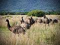 Emus in the park.
 Five Mile Beach
 Five Mile Beach Camp
 Beach near Johnny Souey Cove, home to many crabs.
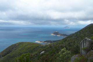 Southeast Point.
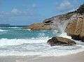 Squeaky Beach
 The Independent Companies Memorial at Tidal River
 Whiskey Beach
- Tidal River seen from Mt Oberon.
 Southeast tip and lighthouse.
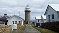 Lighthouse and cabin accommodation.
 Skull Rocks.
 Waterloo Bay.
 Wombat
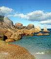 Rocks at Waterloo Bay.
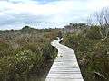 Hiking track to the southeast.
 Oberon Beach.
 Mt Oberon, seen from Oberon Beach.
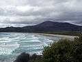 Norman Beach, near Tidal River.
See also
![]() Media related to Wilsons Promontory National Park at Wikimedia Commons
Media related to Wilsons Promontory National Park at Wikimedia Commons
References
- ↑ "Wilsons Promontory". Gazetteer of Australia. Geoscience Australia. Retrieved 2009-06-14.
- ↑ Clark, Ian D.; Hercus, Luise; Laura, Kostanski (2014). Indigenous and Minority Placenames: Australian and International Perspectives. ANU E Press. p. 244. Retrieved 28 March 2016.
- ↑ Flinders, Matthew (1814). A Voyage to Terra Australis. Vol. 1. Pall Mall: G & W Nicoll.
- ↑ Scott, Ernest (1914). The Life of Matthew Flinders. Sydney: Angus & Robertson.
- ↑ "Wilsons Promontory National Park". Parks Victoria. Government of Victoria. 2015. Retrieved 3 July 2016.
- ↑ Carbonell, Rachel (4 April 2005). "Back-burning devastates Wilson's Promontory" (transcript). The World Today. Australia: ABC Local Radio. Retrieved 3 July 2016.
- ↑ Ham, Larissa (27 February 2009). "Firefighters continue to battle Wilsons Prom blaze". The Age. Melbourne.
- ↑ "Wilsons Promontory to reopen this weekend". The Age. Melbourne. 18 March 2009.
- ↑ "Wilsons Promontory after the bushfires". The Sydney Morning Herald.
- ↑ "Southern Prom overnight hikes". Parks Victoria. Retrieved 28 September 2015.
- ↑ "IBA: Wilsons Promontory Islands". Birdata. Birds Australia. Retrieved 2011-11-29.
- ↑ Garnet, J. Roslyn, (with additional chapters by Terry Synan and Daniel Catrice) A History of Wilsons Promontory, Published by the Victorian National Parks Association
- ↑ "Climate Statistics for Wilsons Promontory, VIC". Retrieved February 11, 2012.
External links
- Wilsons Promontory Resources, Parks Victoria.
- A map of the burned area from Prom Map, Parks Victoria.