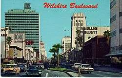
Wilshire Boulevard
| West end | Ocean Avenue in Santa Monica |
|---|---|
| Major junctions |
|
| East end | Grand Avenue in Downtown Los Angeles |
Wilshire Boulevard (/ˈwɪlʃər/ WIL-shər) is one of the principal east-west arterial roads in Los Angeles, California.
Much of the length of the road can be traced back to the indigenous Tongva tribe who used it to bring back tar from the La Brea pits in today's Miracle Mile section of Wilshire Blvd, back to their settlement on the coast. This road was later used by Spanish explorers and settlers, calling it El Camino Viejo ('The Old Road'). The route that ultimately became Wilshire crossed the original pueblo of Los Angeles and five of the original Spanish land grants, or ranchos.[1]
Wilshire was pieced together from various streets over several decades. It began in the 1870s as Nevada Avenue in Santa Monica, and in the 1880s as Orange Street between Westlake (now MacArthur) Park and downtown. Nevada and Orange were later renamed as parts of Wilshire.[1]
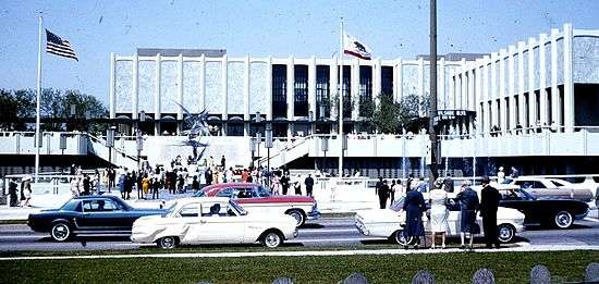
The boulevard was named for Henry Gaylord Wilshire (1861–1927), an Ohio native who made and lost fortunes in real estate, farming, and gold mining.[2] In 1895 he began developing 35 acres of a barley field,[3] stretching westward from Westlake Park for an elite residential subdivision, and donated to the city a strip of land 120 feet wide by 1,200 feet long for a boulevard, on the conditions that it would be named for him and that railroad lines and commercial or industrial trucking would be banned.[1] The road first appeared on a map under its present name in 1895.[4] A historic apartment building on the corner of Wilshire Blvd. and S. Kenmore Ave., the Gaylord, carries his middle name.[5][6]


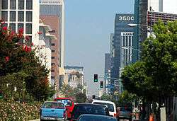

Running 15.83 miles (25.48 km) from Grand Avenue in Downtown Los Angeles to Ocean Avenue in the City of Santa Monica, Wilshire Boulevard is densely developed throughout most of its span, connecting five of Los Angeles's major business districts to each other, as well as Beverly Hills. Many of the post-1956 skyscrapers in Los Angeles are located along Wilshire; for example, "One Wilshire", built in 1966 at the junction of Wilshire on Grand, is said to be "...the main hub of the internet for the entire Pacific Rim"[7] due to the large concentration of telecommunications companies renting space there, such as Wilcon and IX2.[8] Aon Center, at one point Los Angeles' largest (and presently second-largest) tower, is at 707 Wilshire Boulevard in downtown Los Angeles.[9]
The Wilshire Boulevard home of J. Paul Getty was used as the filmset for the 1950 film Sunset Boulevard: it was demolished in 1957.[10]
One particularly famous stretch of the boulevard between Fairfax and Highland Avenues is known as the Miracle Mile.[11] Many of Los Angeles' largest museums are located there. The area just to the east of that, between Highland Avenue and Wilton Place, is referred to as the "Park Mile".[12] Between Westwood and Holmby Hills, several tall glitzy condominium buildings overlook this part of Wilshire, giving it the title of Millionaire's Mile. This section is also known as the Wilshire Corridor and Condo Canyon.
The Wilshire Corridor, located next to Century City, is one of Los Angeles' busiest districts, and contains many high-rise residential towers. The Fox and MGM studios are located in a series of skyscrapers, along with many historic Los Angeles hotels.
Wilshire Blvd is also the principal street of Los Angeles Koreatown, the site of many of Los Angeles' oldest buildings, as well as skyscrapers. Koreatown and Mid Wilshire are among Los Angeles's densest districts.
Transportation
Subway
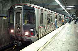
The Purple and Red subway lines of the LACMTA run along Wilshire Boulevard from just past the 7th/Figueroa Street station before serving the Westlake/MacArthur Park and Wilshire/Vermont stations, where the Purple Line continues along Wilshire to serve two stations at Normandie Avenue and at Western Avenue in Koreatown, while the Red Line branches off to terminate in North Hollywood.
The construction of the future Purple Line Extension Section 1 commenced in November 2014. The construction timeline would see the project from the existing Wilshire/Western station to the planned Wilshire/La Cienega station on the corner of Wilshire and La Cienega Boulevard, to be completed by 2023. The phase two and three of the Purple Line, when fully completed, will extend to Westwood/VA Hospital, and will follow Wilshire Blvd for most of its route. Phase four to Santa Monica Beach are still in the planning stages and expected to be completed somewhere between 2022 and 2036, depending on funding.
Metro
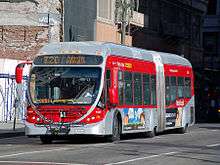
Metro Local Line 20, Metro Rapid Line 720, and Santa Monica Transit Line 2 operate along Wilshire Boulevard. Due to the high ridership of line 720, 60-foot (18 m) NABI articulated buses are used on this route, and bus lanes are in place along some segments of the line.
Features
All of the boulevard is at least four lanes in width, and most of the portion between Hoover Street and Robertson Boulevard has a raised center median. The widest portion is in the business district of central Westwood, where mobs of pedestrians crossing Wilshire at Westwood Boulevard must traverse ten lanes (including two left-turn pockets). According to a 1991 study by the Los Angeles Department of Transportation, this and the nearby intersection of Wilshire and Veteran are among the busiest in Los Angeles.[13] The boulevard's widest portion is in Westwood and Holmby Hills, where it expands to six, and briefly, eight lanes.
The sections of Wilshire Boulevard in the city of Los Angeles are notorious for their giant potholes.[14]
MacArthur Park connection
Wilshire Boulevard formerly ended at the MacArthur Park lake, but in 1934 a berm was built for it to cross and link up with the existing Orange Street (which ran from Figueroa to Alvarado) into downtown Los Angeles. Orange Street was renamed Wilshire and extended east of Figueroa to Grand. This divided the lake into two halves; the northern half was later drained.
The boulevard from west to east
Wilshire Boulevard runs through the following:
- Santa Monica (city)
- West Los Angeles (neighborhood)
- Brentwood (neighborhood)
- Sawtelle (neighborhood)
- Westwood (neighborhood)
- Holmby Hills (neighborhood)
- Beverly Hills (city)
- Beverly Grove (neighborhood) – boulevard flanks southern edge
- Carthay (neighborhood) – boulevard flanks northern edge
- Miracle Mile (historic stretch of the boulevard)
- Hancock Park (neighborhood)
- Wilshire Park (neighborhood)
- Koreatown (neighborhood)
- Westlake (neighborhood)
- Downtown Los Angeles
Landmarks from west to east
- Los Angeles National Cemetery
- Wilshire Federal Building
- Hammer Museum
- Westwood Village Memorial Park Cemetery
- Sephardic Temple Tifereth Israel
- Wilshire Regent
- Sinai Temple
- Los Angeles Country Club
- Beverly Hilton Hotel
- The Regent Beverly Wilshire Hotel
- Rodeo Drive
- Sterling Plaza
- Academy of Motion Picture Arts and Sciences
- Larry Flynt Publications
- Saban Theatre (formerly Fox Wilshire Theater)
- Johnie's Coffee Shop
- Petersen Automotive Museum
- Academy Museum of Motion Pictures (to be constructed)
- Hancock Park
- Los Angeles County Museum of Art
- La Brea Tar Pits and George C. Page Museum
- El Rey Theatre
- E. Clem Wilson Building
- Ebell of Los Angeles
- Los Altos Apartments
- Pellissier Building and Wiltern Theatre
- Wilshire Boulevard Temple
- St. Basil Catholic Church
- Robert F. Kennedy Community Schools (former site of the Ambassador Hotel)
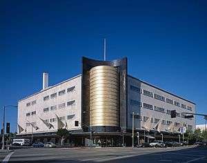
- Southwestern University School of Law (in the former Bullocks Wilshire department store
- The Town House
- Lafayette Park
- Bryson Apartment Hotel
- Park Plaza Hotel
- MacArthur Park (formerly Westlake Park)
- Good Samaritan Hospital
- Wilshire Grand Tower (under construction)
Major intersections
The entire route is in Los Angeles County.
| Location | Destinations | Notes |
|---|---|---|
| Santa Monica | Ocean Avenue | |
| Lincoln Boulevard | ||
| West Los Angeles | Interchange; former SR 7; I-405 exit 55B | |
| Sepulveda Boulevard | ||
| Westwood Boulevard | ||
| Beverly Glen Boulevard | ||
| Beverly Hills | ||
| La Cienega Boulevard | ||
| Los Angeles | Fairfax Avenue | |
| La Brea Avenue | ||
| Crenshaw Boulevard | ||
| Western Avenue | ||
| Vermont Avenue | ||
| Alvarado Street | ||
| Interchange; SR 110 exit 23A | ||
| Figueroa Street | Former US 6 | |
| Grand Avenue |
In popular culture
American singer Lana Del Rey mentions Wilshire Boulevard in the song Honeymoon on her 2015 album of the same name, as well as American Rapper Nipsey Hussle, in the song "Dreamin'" on his fifth mixtape titled "The Marathon".[15][16][17] The 1997 film Volcano features the boulevard being destroyed by volcanic lava. On March 9, 1997, American East Coast rapper The Notorious B.I.G. was seated in the front passenger seat of an SUV, which came to a stop at the red light at the intersection of Wilshire and Fairfax. Another vehicle pulled up next to them, and the driver drew out a pistol and shot B.I.G. four times in a drive-by shooting, killing him.
See also
- Ernest L. Webster, Los Angeles City Council member, 1927–31, helped introduce traffic-signal system
- Harold A. Henry, Los Angeles City Council president active in beautifying the boulevard
References
- 1 2 3 "Birth of the Boulevard | Los Angeles Conservancy". www.laconservancy.org. Retrieved 2016-10-15.
- ↑ Hawthorne, Christopher (23 March 2013). "Wilshire Boulevard, a Main Street that stands apart". LA Times. Accessed 21 September 2013.
- ↑ Roderick (2005), 16
- ↑ Roderick (2005), 10
- ↑ "History". The Historic Gaylord Apartments. Accessed 21 September 2013.
- ↑ Meares, Hadley (June 21, 2013). "The Gaylord Apartments: Luxury, Socialism, and L.A.'s First Failed Co-op". Departures. KCET. Retrieved 19 March 2016.
- ↑ Bullock, Dave (03 March 2008). "A Lesson in Internet Anatomy: The World's Densest Meet-Me Room". Wired. Accessed 21 September 2013.
- ↑ "One Wilshire: Telco Hotel Central". Center for Land Use Interpretation. Accessed 21 September 2013.
- ↑ Ottens, Cale (22 August 2013). "Life at the top: In L.A.'s skyscrapers, diverse firms, great views". LA Times. Accessed 21 September 2013.
- ↑ "The top houses from the movies". Daily Telegraph.
- ↑ Masters, Nathan (11 April 2012). "How the Miracle Mile Got Its Name: A Brief History of L.A.'s Unlikely Retail District". KCET.com. Accessed 21 September 2013.
- ↑ Roderick (2005), 105
- ↑ Hill-Holtzman, Nancy (06 January 1991). "Westside Has L.A.'s Busiest Intersections : Traffic: A city survey attributes the rush of cars to population growth and the area's attractions." LA Times. Accessed 21 September 2013.
- ↑ Steven Leigh Morris, "L.A. Metro Buses Hammered By Potholes on Aging Wilshire Boulevard," LA Weekly, 5 September 2008.
- ↑ "Lana Del Rey – Honeymoon". Genius.
- ↑ "Lana Del Rey releases eerie new track, 'Honeymoon'". Entertainment Weekly's EW.com.
- ↑ "Dreamin'". Genius.com.
Further reading
Books
- Roderick, Kevin; J. Eric Lynxwiler (2005). Wilshire Boulevard: The Grand Concourse of Los Angeles. Los Angeles, CA: Angel City Press. ISBN 1-883318-55-6.
- Rosen, Louis (2011). Henry Gaylord Wilshire: The Millionaire Socialist. Los Angeles, CA: School Justice Institute. ISBN 9780615521244
External links
| Wikivoyage has a travel guide for Wilshire. |
| Wikimedia Commons has media related to Wilshire Boulevard. |
- Wilshire Wonders (kcet.org)
- Curating the City: Wilshire Blvd
- An excerpt from "Wilshire Boulevard: Grand Concourse of Los Angeles", by Kevin Roderick