Wilmore, Kentucky
| Wilmore, Kentucky | |
|---|---|
| City | |
|
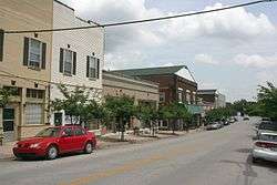
The East Main Street Historic District is listed on the National Register of Historic Places[1] | |
| Motto: "...small town charm" | |
 Location of Wilmore, Kentucky | |
| Coordinates: 37°51′43″N 84°39′42″W / 37.86194°N 84.66167°WCoordinates: 37°51′43″N 84°39′42″W / 37.86194°N 84.66167°W | |
| Country | United States |
| State | Kentucky |
| County | Jessamine |
| Government | |
| • Mayor | Joshua Thompson |
| Area | |
| • Total | 2.6 sq mi (7 km2) |
| • Land | 2.6 sq mi (7 km2) |
| • Water | 0.0 sq mi (0 km2) |
| Elevation | 883 ft (269 m) |
| Population (2000) | |
| • Total | 5,905 |
| • Density | 2,239.1/sq mi (864.5/km2) |
| Time zone | Eastern (EST) (UTC-5) |
| • Summer (DST) | EDT (UTC-4) |
| ZIP code | 40390 |
| Area code(s) | 859 |
| FIPS code | 21-83550 |
| GNIS feature ID | 506874[2] |
Wilmore is a city in Jessamine County, Kentucky, United States.[2] The population was 3,686 at the 2010 census. It is part of the Lexington–Fayette Metropolitan Statistical Area. According to the United States Census Bureau, the city has a total area of 2.6 square miles (6.7 km2), all of it land.
History
A post office called "Wilmore" was established in 1877. It was named for John R. Wilmore, a local landowner and former slave owner.[3][4]
In 1882, the Southern Railway established a line through the county and located a flag stop at Wilmore which was briefly called "Scott's Station". It was named for John D. Scott, the owner of the site. The station's name was soon changed to Wilmore.[3]
By the 1890s, Wilmore was a prosperous settlement with a population of about 600. Wilmore was an important shipping point for cattle, hogs, grain and other produce, and the settlement had a blacksmith, carriage repair shops, two drug stores, three doctors, three large stores, a hardware store, two butcher shops, a livery stable, a school, several churches, a glass mill, and a grist mill. Asbury College was founded in 1890.[4]
Wilmore was incorporated in 1918.[3]
From 1970 to 2012, Wilmore was the original location of both the Ichthus Music Festival, a gathering of Christian musical artists and speakers, and the Highbridge Film Festival, a showcase for locally produced films.[5]
Several locations in Wilmore are listed on the National Register of Historic Places, including the Asbury College Administration Building (renamed the Hager Administration Building),[6] the East Main Street Historic District,[1] the Kenyon Avenue Historic District,[7] the Lexington and Main Historic District,[8] the Morrison-Kenyon Library,[9] and the North Lexington Avenue Historic District.[10]
Demographics
| Historical population | |||
|---|---|---|---|
| Census | Pop. | %± | |
| 1920 | 1,157 | — | |
| 1930 | 1,329 | 14.9% | |
| 1940 | 1,228 | −7.6% | |
| 1950 | 2,337 | 90.3% | |
| 1960 | 2,773 | 18.7% | |
| 1970 | 3,466 | 25.0% | |
| 1980 | 3,787 | 9.3% | |
| 1990 | 4,215 | 11.3% | |
| 2000 | 5,905 | 40.1% | |
| 2010 | 3,686 | −37.6% | |
| Est. 2015 | 6,247 | [11] | 69.5% |
As of the census[13] of 2000, there were 5,905 people, 1,638 households, and 1,215 families residing in the city. The population density was 2,239.1 per square mile (864.5/km2). There were 1,740 housing units at an average density of 659.8 per square mile (254.8/km2). The racial makeup of the city was 94.53% White, 1.93% African American, 0.14% Native American, 2.08% Asian, 0.03% Pacific Islander, 0.32% from other races, and 0.97% from two or more races. Hispanic or Latino of any race were 1.30% of the population.
There were 1,638 households out of which 39.3% had children under the age of 18 living with them, 64.8% were married couples living together, 7.3% had a female householder with no husband present, and 25.8% were non-families. 21.2% of all households were made up of individuals and 7.4% had someone living alone who was 65 years of age or older. The average household size was 2.69 and the average family size was 3.14.
In the city the population was spread out with 22.2% under the age of 18, 26.6% from 18 to 24, 28.0% from 25 to 44, 12.1% from 45 to 64, and 11.2% who were 65 years of age or older. The median age was 26 years. For every 100 females there were 99.0 males. For every 100 females age 18 and over, there were 98.1 males.
The median income for a household in the city was $31,500, and the median income for a family was $40,000. Males had a median income of $26,192 versus $25,362 for females. The per capita income for the city was $13,602. About 9.1% of families and 11.5% of the population were below the poverty line, including 9.9% of those under age 18 and 9.1% of those age 65 or over.
Education
Asbury University (formerly Asbury College) and Asbury Theological Seminary are located in Wilmore.
References
- 1 2 3 "East Main Street Historic District". National Park Service. November 2, 2013.
- 1 2 U.S. Geological Survey Geographic Names Information System: Wilmore
- 1 2 3 Rennick, Robert M. (2013). Kentucky Place Names. University Press of Kentucky.
- 1 2 Wilhite, Wm. G. (1898). Young, Bennett H., ed. Wilmore (PDF). A History of Jessamine County, From Its Earliest Settlement to 1898. Courier-Journal Job Printing. pp. 181, 182, 183, 184.
- ↑ https://www.asbury.edu/highbridge
- ↑ "Asbury College Administration Building". National Park Service. November 2, 2013.
- ↑ "Kenyon Avenue Historic District". National Park Service. November 2, 2013.
- ↑ "Lexington and Main Historic District". National Park Service. November 2, 2013.
- ↑ "Morrison-Kenyon Library". National Park Service. November 2, 2013.
- ↑ "North Lexington Avenue Historic District". National Park Service. November 2, 2013.
- ↑ "Annual Estimates of the Resident Population for Incorporated Places: April 1, 2010 to July 1, 2015". Retrieved July 2, 2016.
- ↑ "Census of Population and Housing". Census.gov. Retrieved June 4, 2015.
- ↑ "American FactFinder". United States Census Bureau. Retrieved 2008-01-31.
Municipalities and communities of Jessamine County, Kentucky, United States | ||
|---|---|---|
| Cities | 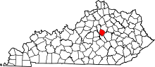 | |
| CDP | ||
| Other unincorporated communities | ||
| Ghost towns | ||
| Central city |  | |
|---|---|---|
| Municipalities with population over 10,000 | ||
| Municipalities with population 5,000-10,000 | ||
| Municipalities with population under 5,000 | ||
| Counties | ||