Will Rogers Turnpike
| |
|---|---|
 | |
| Route information | |
| Length: | 88.5 mi[1] (142.4 km) |
| Existed: | June 28, 1957[2][3] – present |
| Component highways: |
|
| Major junctions | |
| West end: |
|
|
| |
| East end: |
|
| Location | |
| Counties: | Rogers, Mayes, Craig, Ottawa |
| Highway system | |

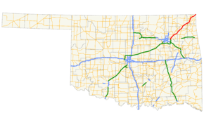
The Will Rogers Turnpike is a freeway-standard toll road in the northeast portion of the U.S. state of Oklahoma. The highway begins as a continuation of the Creek Turnpike in Tulsa, continuing northward from the I-44/US-412 interchange there to the Missouri state line west of Joplin, Missouri. The turnpike carries the I-44 designation for its entire length. The turnpike is 88.5 miles (142.4 km) long and costs $4 to drive one way. The Will Rogers Turnpike opened to traffic on June 28, 1957. It was designated as I-44 in 1958. It is named for Will Rogers, "Oklahoma's Favorite Son".
Route description
The Will Rogers Turnpike begins at an interchange between I-44, US-412, and the Creek Turnpike on the northeast side of Tulsa, straddling the line between Wagoner County and Rogers County. The Creek Turnpike ends at this interchange, with northbound Creek Turnpike traffic continuing onto the Will Rogers Turnpike. I-44 eastbound traffic also merges into the turnpike here. The turnpike heads north to its first interchange, which provides an exit to East Pine Street for westbound traffic and an entrance to the eastbound turnpike. North of the Pine Street interchange, the highway curves to a more northeast course, crossing the Verdigris River. In Verdigris, the turnpike has an interchange at the eastern terminus of SH-266. The turnpike continues northeast to Claremore, county seat of Rogers County, where it junctions SH-20; it also passes under SH-88 in Claremore, with no access provided between the two highways. The turnpike then continues northeast out of Rogers County.[4]
After leaving Rogers County, the Will Rogers Turnpike enters Mayes County. The only interchange in Mayes County is a partial interchange with SH-28 west of Adair. Eastbound motorists can exit the turnpike at SH-28 and motorists on SH-28 can join the turnpike heading westbound. From this interchange, SH-28 continues northeast, entering Craig County.[4]
North of Big Cabin, the Will Rogers Turnpike comes to a junction with US-69. Just northeast of this interchange is the only mainline barrier toll plaza on the turnpike. After the toll plaza, the highway passes under the McDonald's restaurant at the Vinita service plaza (see below). On the east side of Vinita, the road comes to an interchange with US-60 and US-69. From Vinita, the turnpike continues northeast out of Craig County.[4]
The final county that the Will Rogers Turnpike serves is Ottawa County. The first interchange in Ottawa County lies northeast of Afton; here, motorists can access US-59, US-60, and US-69. The turnpike continues to its final interchange, near the county seat, Miami. This interchange serves SH-10. Just north of this interchange is a welcome center for westbound traffic. The highway continues northeast to the state line. I-44 continues east into Newton County, Missouri toward Joplin and Springfield.[4]
History
Because the Will Rogers Turnpike was built prior to authorization of the Interstate Highway System (in 1956), it uses a different set of design standards than today's. As the road has been rebuilt, this is being brought in line with current design practice.
The original route of the Turnpike continued straight into and through Tulsa, becoming Skelly Drive in town (where tolls are not charged). The westernmost portion of the Will Rogers Turnpike was modified so that the Creek and Will Rogers Turnpikes form one road, with motorists required to exit at an interchange to stay on I-44. The original interchange was changed due to numerous difficulties for semis trying to merge into the single lane going to I-44 and Route 66. The new interchange was incorporated into an upgrade of US 412, with provisions for future expansion of the turnpike over a decade later, creating the Creek Turnpike bypass around the Metropolitan area, connecting back to the Turner Turnpike. The remaining pavement of the old alignment is now used as a training ground for the Oklahoma Highway Patrol, among others.
Services
Law enforcement along the Will Rogers Turnpike is provided by Oklahoma Highway Patrol Troop XA, a special troop assigned to the turnpike.[5]
Vinita service plaza

The Will Rogers Turnpike's most prominent service plaza lies between the toll plaza and the Vinita exit. The main feature of this toll plaza is a 29,135-square-foot (2,706.7 m2) McDonald's bridge restaurant spanning the turnpike. Customers can view the traffic passing beneath the restaurant from the dining area through windows overlooking the highway. At the front of the west anchor stands a statue of Will Rogers. A separate Phillips 66 gas station is also available for both directions of travel at the plaza.
The architecture of the McDonald's building is dominated by golden arches on both sides of the building that appear from a distance to be not only the corporate symbol of the chain, but the primary supports for a steel arch bridge structure over the turnpike. Visitors to the eatery exit from either side of the interstate, and then enter through one of the sides and then proceed to the restaurant level via stairs or an elevator.
The building hosting the McDonald's restaurant was originally built when the turnpike opened in 1957 as one of the Glass House restaurants, owned by the now-defunct Interstate Hosts company. Because of this heritage, it is also known as the "Glass House McDonald's" and the "McDonald's Glass House Restaurant". Later, the building also operated as a Howard Johnson's restaurant.[6]
The McDonald's is purported to be the "world's largest." However, the biggest temporary McDonald's in the world was opened during 2012 Summer Olympics in London, which had 3,000 square metres (32,000 sq ft) but it was demolished after the 2012 Summer Olympics.[7][8][9][10][11][12]
The building and service plaza closed on June 4, 2013, for a complete renovation. It reopened on December 22, 2014 with a McDonald's, Subway, and Kum & Go gas stations. It reopened as the Will Rogers Archway.[13][14]
Exit list
| County | Location | mi[15] | km | Exit | Destinations | Notes |
|---|---|---|---|---|---|---|
| Wagoner–Rogers county line | Tulsa–Fair Oaks line | 0.0 | 0.0 | |||
| 0.0 | 0.0 | 33A | East end of US-412 overlap; no exit number eastbound | |||
| Rogers | Fair Oaks | 0.4 | 0.64 | 33B | Western terminus of I-44 concurrency, exit 34 westbound | |
| 1.3 | 2.1 | 35 | E. Pine Street | Westbound exit and eastbound entrance | ||
| Verdigris | 5.6 | 9.0 | 248 | |||
| Claremore | 12.8 | 20.6 | 255 | |||
| Mayes | | 28.3 | 45.5 | 269 | Eastbound exit and westbound entrance | |
| Craig | Big Cabin | 41.2 | 66.3 | 283 | ||
| | 44.3 | 71.3 | Toll plaza | |||
| Vinita | 46.8 | 75.3 | Service plaza | |||
| | 47.8 | 76.9 | 289 | |||
| Ottawa | | 60.5 | 97.4 | 302 | ||
| Miami | 71.7 | 115.4 | 313 | |||
| Oklahoma–Missouri state line | 87.9 | 141.5 | East end of the Will Rogers Turnpike | |||
| 1.000 mi = 1.609 km; 1.000 km = 0.621 mi | ||||||
See also
| Wikinews has related news: Crash kills nine on Oklahoma turnpike |
References
- ↑ Oklahoma Turnpike Authority. "Toll/Fares Chart". Retrieved 2010-11-05.
- ↑ Oklahoma News 9. "OIT Oklahoma Turnpikes Interactive Map". Retrieved 2010-11-05.
- ↑ Oklahoma Turnpike Authority. "OTA History". Retrieved 2010-11-05.
- 1 2 3 4 Official State Map (PDF) (Map) (2013–14 ed.). Oklahoma Department of Transportation. Retrieved December 14, 2013.
- ↑ "Oklahoma Highway Patrol". Retrieved 2008-04-05.
- ↑ "Oklahoma Turnpikes". Highwayhost.org. Retrieved 2013-08-16.
- ↑ "London 2012 Olympics: World's biggest McDonald's with 1,500 seats to be built for games | Mail Online". Dailymail.co.uk. 2012-04-22. Retrieved 2013-08-16.
- ↑ Laurie Hanna (2012-06-25). "Biggest McDonald's in the world will be open for six weeks only - Mirror Online". Mirror.co.uk. Retrieved 2013-08-16.
- ↑ Tepper, Rachel (2012-04-30). "World's Largest McDonald's Coming To 2012 London Summer Olympics (PHOTOS)". Huffingtonpost.com. Retrieved 2013-08-16.
- ↑ Esther Addley (2012-07-28). "London 2012: A supersized McDonald's branch with publicity to match | Sport". theguardian.com. Retrieved 2013-08-16.
- ↑ Louise Eccles (2012-06-25). "World's biggest McDonald's: First pictures inside Olympic Stadium fast food restaurant | Mail Online". London: Dailymail.co.uk. Retrieved 2013-08-16.
- ↑ "Top 10: McDonald's - AskMen". Uk.askmen.com. 2009-10-01. Retrieved 2013-08-16.
- ↑ "OK Turnpike Authority shutting down McDonald's over I-44 for remodel, likely open in 2013". Kjrh.com. 2011-11-16. Retrieved 2013-08-16.
- ↑ "Demolition begins at Vinita Service Plaza on I-44 - KOAM TV 7". Koamtv.com. 2013-08-08. Retrieved 2013-08-16.
- ↑ Google (September 1, 2013). "Will Rogers Turnpike" (Map). Google Maps. Google. Retrieved September 1, 2013.
External links
- Oklahoma Turnpike Authority
- Brief information page about the service plaza
- History from Oklahoma Modern
- Postcards from the original "Glass House"
- Another postcard of the original "Glass House"