Wiesentheid
| Wiesentheid | ||
|---|---|---|
|
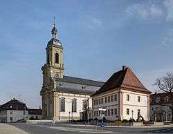
Wiesentheid, church and vicarage. | ||
| ||
 Wiesentheid | ||
Location of Wiesentheid within Kitzingen district 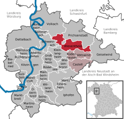 | ||
| Coordinates: 49°48′N 10°21′E / 49.800°N 10.350°ECoordinates: 49°48′N 10°21′E / 49.800°N 10.350°E | ||
| Country | Germany | |
| State | Bavaria | |
| Admin. region | Unterfranken | |
| District | Kitzingen | |
| Government | ||
| • Mayor | Werner Knaier (CSU) | |
| Area | ||
| • Total | 33.33 km2 (12.87 sq mi) | |
| Population (2015-12-31)[1] | ||
| • Total | 4,775 | |
| • Density | 140/km2 (370/sq mi) | |
| Time zone | CET/CEST (UTC+1/+2) | |
| Postal codes | 97353 | |
| Dialling codes | 09383 | |
| Vehicle registration | KT | |
| Website | www.wiesentheid.de | |

Wiesentheid is a municipality in the district of Kitzingen in Bavaria in Germany.
History
It was first mentioned in 918 as "Wisenheida". Mediatization in 1806 brought the former county of Schönborn into the Grand Duchy of Würzburg, along with which it became part of the Kingdom of Bavaria in 1814. The Bavarian Municipal Edict of 17 May 1818 (Gemeindeedikt (de)) formed today's Wiesentheid.[2]
Main sights
- Count's Castle Wiesentheid
- Kanzleistrasse – street with historic administrative buildings
- Schlossparkanlage – castle garden (English)
- catholic church St.Mauritius built by Balthasar Neumann
- historic vicarage
- historic town hall
- crucifixion memorial built by Jacob van der Auvera
- historic Mariensäule (memorial of Mother Mary)
Sister city
References
- ↑ "Fortschreibung des Bevölkerungsstandes". Bayerisches Landesamt für Statistik und Datenverarbeitung (in German). June 2016.
- ↑ H. Clément: Das bayerische Gemeindeedikt vom 17. Mai 1818. Ein Beitrag zur Entstehungsgeschichte der kommunalen Selbstverwaltung in Deutschland. Diss. Freiburg i. B., 1934.
External links

Wiesentheid Castle of the Counts of Schönborn, built from 1701 for Rudolf Franz Erwein von Schönborn
| Ecclesiastical |  | |
|---|---|---|
| Secular |
| |
| Counts / Lords |
| |
| Cities | ||
Circles est. 1500: Bavarian, Swabian, Upper Rhenish, Lower Rhenish–Westphalian, Franconian, (Lower) Saxon Circles est. 1512: Austrian, Burgundian, Upper Saxon, Electoral Rhenish · Unencircled territories | ||
This article is issued from Wikipedia - version of the 5/17/2015. The text is available under the Creative Commons Attribution/Share Alike but additional terms may apply for the media files.