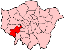
Whitton, London
| Whitton | |
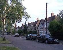
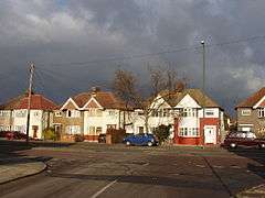 Houses, Nelson Road, in this largely residential district. |
|
 Whitton |
|
| Area | 1.62 km2 (0.63 sq mi) |
|---|---|
| Population | 9,752 (2011 Census Whitton ward 2011)[1][2] |
| – density | 6,020/km2 (15,600/sq mi) |
| OS grid reference | TQ145735 |
| London borough | Richmond |
| Ceremonial county | Greater London |
| Region | London |
| Country | England |
| Sovereign state | United Kingdom |
| Post town | TWICKENHAM |
| Postcode district | TW2, TW3, TW4 |
| Dialling code | 020 |
| Police | Metropolitan |
| Fire | London |
| Ambulance | London |
| EU Parliament | London |
| UK Parliament | Twickenham |
| London Assembly | South West |
Coordinates: 51°26′56″N 0°21′05″W / 51.4488°N 0.3513°W
Whitton is a town in the London Borough of Richmond upon Thames. It was part of the ancient parish of Twickenham, of which it was long a semi-rural part. This changed when it acquired its own railway station; it is the only modern district of Twickenham which is north of the River Crane and is somewhat characterised by the only dual carriageway in the area, with a pub-hotel on the route. Its greater conversion of land use into housing and evolution into a small town in the former county of Middlesex took place from c. 1930–1960 and it has a central cluster of shops, banks and other businesses.
History
Early history and notable architecture through the ages
Whitton is first mentioned in historical documents around 1200, though it had probably been settled a century or so earlier. It remained an archetypal hamlet for centuries (specifically of Twickenham parish)[3] but by the 16th century had already begun to attract outsiders. The Elizabethan and Jacobean courtier Sir John Suckling built a house in the vicinity of the present Murray Park (his son the poet Sir John Suckling was born in Whitton in 1609). Sir John later replaced his first house with a grander residence on land adjoining today's Warren Road. (The term Warren is itself historical, indicating the presence at one time of rabbit burrows – or warrens – an important source of food.)
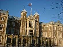
Around 1640 Edmund Cooke built a large house close to the centre of the village. This was later bought by the court painter Sir Godfrey Kneller who pulled it down and in 1709 erected his own larger house. This in turn was considerably modified by later owners and was eventually acquired by the state in 1847 for use as a teacher training college. By this time the surviving parts of Kneller's original structure had become unsafe and were demolished. They were replaced by new wings, producing Kneller Hall, the building seen today. Several local roads and buildings are named after the painter, including Kneller Road, Kneller Gardens, Godfrey Avenue and Kneller School.
The training college was not a success and lasted less than a decade. The building was next converted into a school for military bandsmen, in which capacity as the home of the Royal Military School of Music we know it today.[4] The School has long been renowned not only for its status as the leading establishment of its kind and for providing musicians for a wide variety of State occasions, but for its summer programme of open-air concerts in the extensive grounds of the Hall. Some of these are accompanied by fireworks displays, including re-enactments of the Battle of Waterloo to the accompaniment of Beethoven's Battle Symphony (Wellington's Victory).
During and for a time after the Second World War, Kneller Hall was used as a hospital and convalescent home for wounded servicemen.
At the centre of the original village, about 200 m from Kneller Hall is the White Hart, an inn dating back at least to the mid-17th century and possibly much earlier. Records relating to this inn seem to suggest that Whitton had an importance that was not well recorded, or that travellers passed through it in considerable numbers. A document of 1685 shows that it provided three beds, and stabling for ten horses; numbers which did not seem to fit with Whitton's apparent status as a sleepy rural hamlet with only a few dozen inhabitants.
At the northern end of Whitton was Whitton Park, the estate of the third Duke of Argyll, which he established in 1722 on land that had been enclosed some years earlier from Hounslow Heath. The Duke was an enthusiastic gardener and he imported large numbers of exotic species of plants and trees for his estate; he had professional advice from the Scottish gardener James Lee (1715—1795). After the Duke's death his nephew, the third Earl of Bute, moved many of these, including mature trees, to the Princess of Wales' new garden at Kew. This later became Kew Gardens and some of the Duke's trees can still be seen there to this day.
On a humbler level, some houses survive from the period before the 1930s development. There are short terraces of early 19th century workers' cottages in Nelson Road near the Admiral Nelson public house and on the eastern side of Hounslow Road a little to the north of the Baptist Church.
Another row of similar cottages, one of which had been converted into Reay's Timber Yard, existed until the early 1960s in Hounslow Road close to Holly Bush Corner at the junction with Nelson Road and the High Street. Still present at Holly Bush Corner is an old cottage that served until the late 1950s as a corner shop occupied and operated by Bob Anderson, who was a great favourite with local children, and was instantly recognizable from his trademark crisp white apron.
Houses dating from around the turn of the 20th century exist at the centre of the old village in Nelson Road and Seaton Road, while Prospect Crescent has examples of both private Edwardian terraces and a small early council estate. Whitton Lodge, a large Victorian villa standing in its own grounds occupied the site immediately opposite Holly Bush Corner at the junction of Nelson and Hounslow Roads until it was replaced in the 1950s by a small estate of low-rise flats.
Early 20th century
As recently as Victorian times Whitton was renowned as a 'market garden', known for its roses, narcissi, lilies of the valley and for its apple, plum and pear orchards. Indeed, until the 1920s the village was still separated from the surrounding towns by open fields and much of the earlier character of the old village was retained well into the 1940s. However, in little more than a decade all that changed.
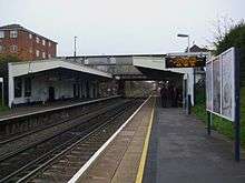
Although there was a little housing development in the 19th century, on Nelson and Hounslow Roads and in the area between Kneller and Nelson Roads, Whitton remained a quiet country village. However, following the opening of Whitton railway station in Percy Road in 1931, housing development rapidly replaced the market gardens and the former Argyll Estate, having been sold for development in the 1890s. New parades of shops were built on either side of Percy Road from the railway station bridge to the junction with Nelson and Hounslow Roads. This stretch then became known as "High Street" Whitton.
At the northeast corner of the High Street, opposite the Admiral Nelson public house, the parade included an Odeon cinema, which functioned until the 1960s.
For twenty years westbound railway passengers had to descend the steps from the High Street to the booking office on platform level to purchase their tickets, then climb the steps again, cross the bridge, and descend more steps to the opposite platform. This inconvenience did not come to an end until the construction of the present street-level booking office in 1950, together with a footbridge parallel to the road bridge. During that period the railway was still by far the most common way for people to travel to work.
World War II
A number of houses were damaged by enemy bombing in the early years of the Second World War. Before 1944, 86 Hounslow Road received a direct hit from a German bomb and was badly damaged, though not destroyed. In June 1944, 81 High Street received a direct hit from a V1 flying bomb. Part of the parade of shops and the flats above was totally destroyed and several people were killed. Around the same time a house in Lincoln Avenue was also destroyed by a V1 and several adjoining houses were severely damaged.
There was certainly a great deal of activity in the skies over Whitton during the early years of the war with the sound of air raid sirens and anti-aircraft guns very common by both day and night. A common sight during the Blitz was of RAF fighters scrambling from nearby airfields almost at rooftop height and low enough for the pilots to be seen in their cockpits. One prominent air raid siren was mounted on top of a mast located on the triangle of land at the junction of Nelson and Warren Roads. Next to it, and for many years after, was a blue police telephone box of the type still familiar today as the TARDIS in the Doctor Who television series.
The site of the former gunpowder mills in Crane Park was also used for play, the Shot Tower, sluices and earth blast banks providing a perfect adventure environment in which children could exercise their imagination.
Economy since World War II
In line with the United Kingdom, home working has increased; however, since the late 1960s, the M3 motorway (and its extension into London, the A316 road passing through the area) have together opened up work in self-employed trades, commerce, retail, across the outer suburbs and region including the M4 corridor, London Heathrow and in light industry which was previously not available to the workforce.
Recreation since World War II
The area required and had few cars, which were relatively expensive, until well into the 1950s. Recreation grounds at the time included Murray Park, the Kneller Recreation Ground in Meadway, and Crane Park.
Aside from, for instance, conkers and marbles, fishing occupied families for tadpoles, newts, sticklebacks and other small fish or tiddlers using jam jars suspended from loops of string in the streams: the Crane and the stretch of the Duke of Northumberland's River from Meadway to the Chertsey Road.
Despite home entertainment and car ownership becoming almost ubiquitous, many of these activities to a greater or lesser degree continue in the town today thanks to preservation of the green spaces. There are currently tennis courts, football and stream-side paths at Kneller Gardens by the streams, Kingfishers often visiting the streams.[5]
Education
In 1851 a Church of England elementary school was opened in the grounds of Kneller Hall, its playground adjoining Whitton Dene and Kneller Road surrounded by a high brick wall and a line of horse-chestnut trees. Originally co-educational, by the end of the Second World War it had become a boys-only school and remained in use until the 1960s. The name of the school was changed to "Whitton Boys Church of England Boy's School", known locally simply as "Whitton Boys".
The Nelson Road Primary School opened in 1911 and is still in use today as Nelson Primary School.[6] Bishop Perrin Church of England School opened in 1936 and the building served as a school and as a church. Heathfield Primary School in Powder Mill Lane is housed in buildings that were designed to be used as a hospital. St. Edmund's Roman Catholic Primary School opened in 1939 and is situated on the Nelson Road alongside St. Edmund's Catholic Church. It celebrated its 70th anniversary in September 2009.
The Kneller Secondary Modern School in Meadway opened in 1936, boys were housed in one half of the building and girls at the other. The boys moved out in March 1959 to attend Whitton Secondary School. Kneller Girls' School took over the whole building, the metalwork and wood work rooms were taken out to be replaced by rooms for cookery and for needlework. In 1978 the school moved to Fifth Cross Road, Twickenham and merged, in 1980, with Twickenham Girls School to become Waldegrave School for Girls.[7] Several small private schools also operated during the 1940s. There is also a primary school in Whitton called Chase Bridge,[8] opened in 1953 and still operating. Whitton School, which opened in March 1959, was an 11–16 mixed Sports College. Whitton School became Twickenham Academy, in 2010, under the sponsorship of the Swedish company Kunskapsskolan.
Churches
In 1862 the Gostling family, owners of part of the former estate of the Duke of Argyll, donated land at the junction of Hounslow and Kneller Roads for the Church of St Philip and St James (C of E) and for an adjoining vicarage, since replaced.
A non-conformist Gospel Hall was built in 1881 on the western side of Nelson Road a few metres to the north of the junction with Warren Road. This became redundant with the opening of Whitton Baptist Church in Hounslow Road in 1935 and was later used by various commercial enterprises. The building of Whitton Baptist Church was funded by the compensation paid for the compulsory purchase of St Margaret's Baptist Church, which was demolished during the construction of the Great Chertsey Road approach to the new Twickenham Bridge across the Thames in 1932.
Whitton Methodist Church in Percy Road dates from the period of residential development in the 1930s and St Augustine of Canterbury, Whitton in Hospital Bridge Road opened in 1958. Before then services had been held in Bishop Perrin C of E School which had opened in 1936. The Catholic Church of St Edmund of Canterbury is in Nelson Road.
Shops and businesses
Apart from the High Street shopping parades introduced in the 1930s, many traditional shops have continued to thrive until the present, though the nature of their business has changed with the times. Nonetheless even after the war there were numerous examples of traders catering to the specific needs of what until only a decade or two earlier had remained a self-contained rural community. These included several general and grocery stores, one of which survived a few doors along Nelson Road from the Admiral Nelson until the mid-1950s. This type of one-stop household supplier was eventually swept away by the modern supermarket.
Other businesses that survived into the fifties and sixties were cobblers (traditional shoe repairers) in Nelson Road opposite the Admiral Nelson and at the terrace of shops near the junction of Nelson and Warren Roads; a cycle repair business in the same terrace, that continued to provide a vital service to the many residents who relied on their bicycles for their daily transport until the late 1950s and at various times fish and chip shops in Nelson Road in the old village and a few doors down from Holly Bush Corner.
In Hounslow Road there were a confectioner/tobacconist run by an elderly lady until her death in the early 1950s; an electrical store where residents took the lead-acid accumulators from their wireless sets once a week for re-charging; and a toyshop. New shops were incorporated into the facade of the Baptist church in 1935. For many years one of these was occupied by a hairdresser who advertised Marcel Permanent Waving. A second shop was not let out but used as a Sunday School room.
In the early years of the War a familiar sight in the village was a traditional gilt barleysugar-pillared Italian ice-cream wagon drawn by a horse, though this eventually disappeared as a result of rationing. During the same period, opposite the Gospel Hall was a coal dealer's yard which was a great attraction to children for the massive Foden steam lorry the dealer used to make his deliveries. A fine example was restored to full working order during the 1990s at the Kew Bridge Steam Museum.
Although it was a bucolic reminder of Whitton's former status as an important farming and market gardening centre, one business that was not popular with nearby residents was an extensive pig farm that operated on land between Tranmere and Nelson Roads until the early 1950s.
Demography and housing
| Ward | Detached | Semi-detached | Terraced | Flats and apartments | Caravans/temporary/mobile homes/houseboats | Shared between households[2] |
|---|---|---|---|---|---|---|
| (ward) | 826 | 1,770 | 908 | 492 | 0 | 11 |
| Ward | Population | Households | % Owned outright | % Owned with a loan | hectares[2] |
|---|---|---|---|---|---|
| (ward) | 9,752 | 3,675 | 35 | 39 | 162 |
Transport
Tube/Trains
- Station
The town does not have a London Underground station, connection is often made at Richmond.
Buses
- London Buses serve Whitton
| Bus Map | ||||||||||||||||||||||||||||||||||||||||||||||||||||||||||||||||||||||||||||||||||||||||||||||||||||||||||||||||||||||||||||||||||||||||||||||||||||||||||||||||||||||||
|---|---|---|---|---|---|---|---|---|---|---|---|---|---|---|---|---|---|---|---|---|---|---|---|---|---|---|---|---|---|---|---|---|---|---|---|---|---|---|---|---|---|---|---|---|---|---|---|---|---|---|---|---|---|---|---|---|---|---|---|---|---|---|---|---|---|---|---|---|---|---|---|---|---|---|---|---|---|---|---|---|---|---|---|---|---|---|---|---|---|---|---|---|---|---|---|---|---|---|---|---|---|---|---|---|---|---|---|---|---|---|---|---|---|---|---|---|---|---|---|---|---|---|---|---|---|---|---|---|---|---|---|---|---|---|---|---|---|---|---|---|---|---|---|---|---|---|---|---|---|---|---|---|---|---|---|---|---|---|---|---|---|---|---|---|---|---|---|---|
Legend | ||||||||||||||||||||||||||||||||||||||||||||||||||||||||||||||||||||||||||||||||||||||||||||||||||||||||||||||||||||||||||||||||||||||||||||||||||||||||||||||||||||||||
| ||||||||||||||||||||||||||||||||||||||||||||||||||||||||||||||||||||||||||||||||||||||||||||||||||||||||||||||||||||||||||||||||||||||||||||||||||||||||||||||||||||||||
|
Companies | ||||||||||||||||||||||||||||||||||||||||||||||||||||||||||||||||||||||||||||||||||||||||||||||||||||||||||||||||||||||||||||||||||||||||||||||||||||||||||||||||||||||||
Geography
 |
Hounslow West | Hounslow | Isleworth | |
| Hanworth | |
Twickenham | ||
| ||||
| | ||||
| Hampton | Fulwell | Teddington |
References
- ↑ Census Information Scheme (2012). "2011 Census Ward Population Estimates". Greater London Authority. Retrieved 30 January 2013.
- 1 2 3 Key Statistics; Quick Statistics: Population Density United Kingdom Census 2011 Office for National Statistics Retrieved 20 December 2013
- ↑ Susan Reynolds (Editor) (1962). "Map of Parishes". A History of the County of Middlesex: Volume 3. Institute of Historical Research. Retrieved 20 December 2013.
- ↑ Historic England. "Details from listed building database (1065380)". National Heritage List for England. Kneller Hall
- ↑ Kneller Gardens
- ↑ Nelson Primary School
- ↑ Waldegrave School for Girls
- ↑ Chase Bridge