Whitehaven Beach
Whitehaven Beach is a 7 km stretch along Whitsunday Island, Australia. The island is accessible by boat from the mainland tourist ports of Airlie Beach and Shute Harbour, as well as Hamilton Island. It lies across from Chalkie's Beach on Haslewood Island.
The Whitehaven Beach Ocean Swim is a 2 km open swimming competition held on the beach in November each year since 2009 as part of the Hamilton Island Triathlon. The 2012 event was held on 11 November 2012.[1]
History
The beach was named and discovered in 1879 by Staff Commander EP Bedwell. Being one of the many names from the then English county of Cumberland Bedwell brought to the area following James Cook's 1770 naming of the island group The Cumberland Islands.[2]
Geography

The beach was awarded Queensland's Cleanest Beach in Keep Australia Beautiful's 2008 Clean Beach Challenge State Awards.[3] In July 2010, Whitehaven Beach was named the top Eco Friendly Beach in the world by CNN.com.[4] Dogs are not permitted on the beach and cigarette smoking is prohibited.[3]
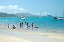
Whitehaven Beach is known for its white sands. It has a beautiful scenery and the sand consists of 98% pure silica which gives it a bright white color. Local rocks do not contain silica so it has been suggested that the sands were brought to the beach via prevailing sea currents over millions of years.[5]
Unlike regular sand, the sand on Whitehaven Beach does not retain heat making it comfortable to walk barefoot on a hot day. This sand is also very fine, and can damage electronic equipment such as telephones and cameras, although it is good at polishing up jewellery.
See also
References
- ↑ Whitehaven Beach Ocean Swim - Race Information.
- ↑ Whitehaven Beach at Sailing-Whitsundays.com
- 1 2 "Whitehaven named cleanest beach in Queensland". Whitsunday Times. APN News & Media Ltd. 11 December 2008. Retrieved 29 July 2010.
- ↑ "Queensland beach named world's best". Australian Geographic. 22 July 2010. Retrieved 29 July 2010.
- ↑ "Parks of the Whitsundays - Nature, culture and history". Department of Environment and Resource Management. 21 June 2010. Retrieved 29 July 2010.
External links
 Media related to Whitehaven Beach at Wikimedia Commons
Coordinates: 20°16′43″S 149°02′11″E / 20.27861°S 149.03639°E