Wheeling Creek (West Virginia)
| Wheeling Creek | |
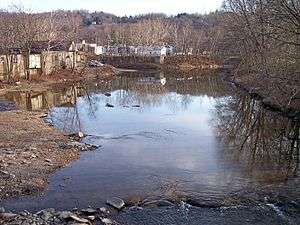 Wheeling Creek in Wheeling in 2006 | |
| Country | United States |
|---|---|
| State | West Virginia |
| Counties | Marshall, Ohio |
| Source | Enlow Fork |
| - location | boundary of Greene and Washington Counties, Pennsylvania |
| - elevation | 1,339 ft (408 m) [1] |
| - coordinates | 40°00′08″N 80°20′27″W / 40.00222°N 80.34083°W [2] |
| Secondary source | Dunkard Fork |
| - location | Confluence of North Fork and South Fork, Richhill Township, Greene County, Pennsylvania |
| - elevation | 927 ft (283 m) [1] |
| - coordinates | 39°53′33″N 80°28′41″W / 39.89250°N 80.47806°W [3] |
| Source confluence | |
| - location | northeastern Marshall County near Majorsville, West Virginia |
| - elevation | 829 ft (253 m) [1] |
| - coordinates | 39°57′15″N 80°31′43″W / 39.95417°N 80.52861°W [4] |
| Mouth | Ohio River |
| - location | Wheeling, West Virginia |
| - elevation | 630 ft (192 m) [1] |
| - coordinates | 40°03′50″N 80°43′30″W / 40.06389°N 80.72500°WCoordinates: 40°03′50″N 80°43′30″W / 40.06389°N 80.72500°W [4] |
| Length | 25 mi (40 km) [4] |
| Basin | 300 sq mi (777 km2) approx.[5] |
| Discharge | for Elm Grove, Wheeling |
| - average | 343 cu ft/s (9.7 m3/s) [5] |
| - max | 22,300 cu ft/s (631.5 m3/s) |
| - min | 0.1 cu ft/s (0.0 m3/s) |
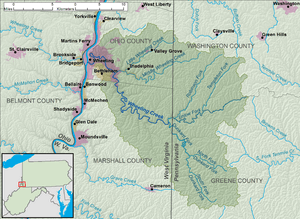 A map of Wheeling Creek and its watershed | |

Wheeling Creek is a tributary of the Ohio River, 25 miles (40 km) long, in the Northern Panhandle of West Virginia in the United States, with a watershed extending into southwestern Pennsylvania. Via the Ohio River, it is part of the watershed of the Mississippi River, draining an area of approximately 300 square miles (780 km2) on the unglaciated portion of the Allegheny Plateau. It flows into the Ohio River in downtown Wheeling, just downstream of Ohio's Wheeling Creek on the opposite bank.[6] According to the Geographic Names Information System, it has also been known as Big Wheeling Creek.[4]
Geography
Wheeling Creek is formed in northeastern Marshall County, West Virginia, by the confluence of streams known as the Enlow Fork and the Dunkard Fork:
- Enlow Fork, also known historically as "Enslow Fork,"[2] rises in Pennsylvania on the boundary of Greene and Washington Counties, and flows west-southwestwardly along that boundary into Marshall County. Enlow Fork defines the northern boundaries of Morris, Gray, and Richhill Townships in Greene County; and the southern boundaries of Morris, East Finley, and West Finley townships in Washington County.[7]
- Dunkard Fork, also known historically as "Crow Creek,"[3] is formed in Pennsylvania by the confluence of the North Fork Dunkard Fork[8] and the South Fork Dunkard Fork[9] in Richhill Township in Greene County, and flows northwestwardly into Marshall County. Its north and south forks each flow northwestwardly into Richhill Township; the North Fork rises in Jackson Township and flows through Ryerson Station State Park, where it is dammed to form a lake; and the South Fork rises in Aleppo Township.[7]
From the confluence of the Dunkard and Enlow forks, Wheeling Creek flows northwestwardly into the city of Wheeling in Ohio County. In the Elm Grove neighborhood of Wheeling, it collects Little Wheeling Creek,[10] which rises in Ohio County just west of the Pennsylvania state line and flows southwestwardly through the communities of Valley Grove and Triadelphia. In Triadelphia, Little Wheeling Creek collects Middle Wheeling Creek,[11] which rises in West Finley Township in Greene County, Pennsylvania, and flows generally westwardly into southeastern Ohio County.[6][7]
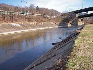
The National Road (U.S. Route 40) parallels Little Wheeling Creek through eastern Ohio County, and follows Wheeling Creek for part of its route through the city of Wheeling;[6] the creek is also paralleled for five miles (8 km) in Wheeling by a rail trail as part of the Wheeling Heritage Trail network.[12]
According to the West Virginia Department of Environmental Protection, of the 141 square miles (370 km2) drained by Wheeling Creek in West Virginia, approximately 67% is forested; approximately 27% is used for agriculture; and approximately 5% is urban.[13]
Flow rate
The United States Geological Survey operates a stream gauge on the creek in the Elm Grove neighborhood of Wheeling, downstream of the mouth of Little Wheeling Creek and 7.8 miles (12.6 km) upstream of the creek's mouth. Between 1941 and 2005, the annual mean flow of the creek at the gauge was 343 cubic feet per second (9.7 m³/s). The creek's highest flow during the period was estimated at 22,300 ft³/s (632 m³/s) on September 17, 2004. The lowest recorded flow was 0.1 ft³/s (0 m³/s) on October 7, 1963, and on two days in September 1964.[5]
Fishing
Wheeling Creek is a popular fishing destination to those close to it. There are many entry points located alongside the Wheeling Heritage Trail System. There are a variety of fish species including muskellunge, smallmouth bass, sunfish, hognose suckers, various species of catfish, and bluegill. Wheeling Creek is also regularly stocked with rainbow trout and brown trout.[14]
See also
- List of tributaries of Wheeling Creek
- Elm Grove Stone Arch Bridge
- Fisher Site — archeological site along Enlow Fork.
- List of West Virginia rivers
References
- 1 2 3 4 Google Earth elevation for GNIS coordinates. Retrieved on 2007-06-14.
- 1 2 Geographic Names Information System. "Geographic Names Information System entry for Enlow Fork (Feature ID #1174270)". Retrieved 2007-03-17.
- 1 2 Geographic Names Information System. "Geographic Names Information System entry for Dunkard Fork (Feature ID #1173610)". Retrieved 2007-03-17.
- 1 2 3 4 Geographic Names Information System. "Geographic Names Information System entry for Wheeling Creek (Feature ID #1548996)". Retrieved 2007-03-17.
- 1 2 3 Ward, S. M.; G. R. Crosby. "Water Resources Data, West Virginia, Water Year 2005". United States Geological Survey. pp. Upper Ohio and Little Kanawha River Basins. Retrieved 2007-06-14.
- 1 2 3 West Virginia Atlas & Gazetteer. Yarmouth, Me.: DeLorme. 1997. p. 21. ISBN 0-89933-246-3.
- 1 2 3 Pennsylvania Atlas & Gazetteer. Yarmouth, Me.: DeLorme. 2003. pp. 70, 84–85. ISBN 0-89933-280-3.
- ↑ Geographic Names Information System. "Geographic Names Information System entry for North Fork Dunkard Fork (Feature ID #1198104)". Retrieved 2007-03-17.
- ↑ Geographic Names Information System. "Geographic Names Information System entry for South Fork Dunkard Fork (Feature ID #1198127)". Retrieved 2007-03-17.
- ↑ Geographic Names Information System. "Geographic Names Information System entry for Little Wheeling Creek (Feature ID #1542252)". Retrieved 2007-03-17.
- ↑ Geographic Names Information System. "Geographic Names Information System entry for Middle Wheeling Creek (Feature ID #1181059)". Retrieved 2007-03-17.
- ↑ "Wheeling Heritage Trail". Retrieved 2007-03-17.
- ↑ West Virginia Department of Environmental Protection. "Watershed Atlas Project.". pp. Upper Ohio River 2. Archived from the original on 2005-04-04. Retrieved 2007-03-17.
- ↑ "Trout Stocking Schedule". West Virginia Division of Natural Resources. Retrieved 13 October 2013.
External links
| Wikimedia Commons has media related to Wheeling Creek (West Virginia). |
- USGS real-time water data for Wheeling Creek at Elm Grove
- USGS real-time water data for Dunkard Fork near Majorsville
- stocking information