Whakamaru to Brownhill Road transmission line
| Whakamaru to Brownhill Road transmission line | |
|---|---|
|
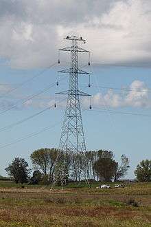
Whakamaru to Brownhill Road transmission line near Te Kauwhata | |
| Location | |
| Country | New Zealand |
| General direction | South-North |
| From | Whakamaru Power Station, southern Waikato |
| To | Brownhill Road switching station, southeastern Auckland |
| Ownership information | |
| Owner | Transpower New Zealand |
| Operator | Transpower New Zealand |
| Construction information | |
| Construction started | February 2010 |
| Commissioned | 30 October 2012 |
| Technical information | |
| Type | Overhead transmission line |
| Type of current | HVAC |
| Total length | 186 km (116 mi) |
| Power rating | 2700 MVA per circuit at 400 kV |
| AC Voltage |
400 kV design 220 kV initially |
| Number of circuits | Two |
The Whakamaru to Brownhill Road transmission line is a double-circuit 400 kV capable transmission line constructed by Transpower to increase the capacity of the National Grid between the southern Waikato and the city of Auckland. The line runs from the Whakamaru sub-station near the Whakamaru Power Station, over a distance of 186 kilometres (116 mi) to the new Brownhill Road substation near Whitford in southeastern Auckland. The line will initially be operated at 220 kV. From Brownhill Road, 220 kV underground cables connect the line to the Pakuranga sub-station in eastern Auckland. The project was the subject of considerable controversy and protest during the planning and approval stages. Construction of the line started in February 2010, and the line was commissioned on 30 October 2012.[1] The transmission line forms the major part of a wider North Island Grid Upgrade project with a forecast cost to completion of $894 million. [2]
Overview
The line was a major enhancement to the National Grid and was designed to increase electrical supply and security to Auckland and Northland. The line provides more transmission capacity between the Waikato hydro stations and Auckland, and takes load off the existing 220 kV lines. Prior to the commissioning of the new line, all existing major transmission lines into Auckland converged on Otahuhu substation, creating a concentration of risk to the security of supply to Auckland and Northland. The new line terminates at the Pakuranga substation instead, creating diversity of electricity supply to Auckland.
The line was designed and built for 400 kV operation, but currently operates at 220 kV. In future, possibly by 2030, the installation of 220/400 kV transformers at Whakamaru and Brownhill Road will allow the transmission line to be operated at 400 kV. At that time, additional underground cables may be installed to connect Brownhill Road directly to Otahuhu substation.
Background
The population of Auckland is growing, and is expected to reach 1.6 million inhabitants by 2016, and 1.7 million by 2020.[3] There are very few power stations north of Auckland, which means that the electricity requirements for Auckland city and Northland must be supplied from the south - especially from the hydroelectric power stations on the Waikato River and the dual-fuelled Huntly Power Station.
Prior to the commissioning of this new transmission line, there were six lines running north into Auckland:
- A double-circuit 220 kV line from Ohinewai (near Huntly) to Otahuhu via Huntly and Takanini, with one circuit also going via Drury.
- A double-circuit 220 kV line from Whakamaru to Otahuhu via Ohinewai, with one circuit also going via Hamilton.
- Two single-circuit 220 kV lines from Whakamaru to Otahuhu direct.
- A double-circuit 110 kV line from Arapuni to Otahuhu, via Hamilton, Bombay and Wiri.
- A single-circuit 110 kV line from Arapuni to Bombay direct
The Ohinewai-Huntly-Otahuhu line was the last of these transmission lines to be built into Auckland, commissioned in the late 1970s to export electricity out of the then under-construction Huntly Power Station. Since then, the population of the upper North Island has more than doubled, and electricity use has trebled.
Power supply to the Upper North Island is dependent largely on two major factors: the generation from Huntly and the transmission capacity between Huntly and Otahuhu; and generation from Whakamaru and south of Whakamaru, and the transmission capacity between Whakamaru and Otahuhu.[4] For the transmission system as at 2010, issues that could arise during periods of high demand and low generation in the Auckland area included:
- an outage of a Huntly–Otahuhu circuit may overload the other Huntly–Otahuhu circuit
- an outage of a Huntly–Ohinewai circuit may overload the other Huntly–Ohinewai circuit
- the two 220 kV Otahuhu–Whakamaru circuits may overload during a contingency
- an outage of the Hamilton–Whakamaru circuit may overload the two 110 kV Arapuni–Hamilton regional circuits
- an outage of the Hamilton–Ohinewai circuit may cause low voltage at the Hamilton 220 kV bus.
The North Island Grid Upgrade (NIGU) project, including the Whakamaru to Brownhill transmission line, addresses these issues, although forecasts predict the last issue (Hamilton–Ohinewai outage causing low voltage at Hamilton) will reappear towards 2025. The project also increases the power transfer capacity into Auckland, and reduces the loading on the existing 220 kV Otahuhu–Whakamaru and Huntly–Otahuhu circuits, with a consequential reduction in the reactive support needed in the Upper North Island.[4]
Project Timeline
Key milestones in the history of the project are:
- May 2005 – Transpower submitted an Investment Proposal for a 400 kV line from Whakamaru to Otahuhu to the Electricity Commission, under transitional provisions of the Electricity Governance Regulations 2003 [5]
- 30 September 2005 - Transpower submitted its 2005 Grid Upgrade Plan to the Electricity Commission, including several investment proposals, one of which was a revised version of the proposal for a 400 kV line from Whakamaru to Otahuhu [6]
- 27 April 2006 - Electricity Commission announced a draft decision not to approve the Transpower Grid Upgrade Plan proposal for a 400 kV line from Whakamaru to Otahuhu (because it considered there were other lower cost alternatives) [7]
- 20 October 2006 - Transpower submitted a revised proposal, for a 400 kV capable transmission line that would be initially operated at 220 kV, terminating south of Auckland, with 220 kV cables to Pakuranga substation [8]
- 31 January 2007 - The Electricity Commission issued a notice of its intention to approve the proposal but agreed to hold a public conference. The public conference was held in May.
- 27 May 2007 – Transpower lodged “Notices of Requirement” under the Resource Management Act 1991, with seven affected local councils[9]
- 5 July 2007 – The Electricity Commission announced its final decision to approval the proposal [10]
- 9 August 2007 - Cabinet Minister Pete Hodgson announced he would use powers under the Resource Management Act to "call in" Transpower's proposal to build the electricity transmission line from Waikato to Auckland, because of its national significance, and establish a Board of Inquiry to consider the designations and resource consents required for the project [11][12]
- 25 March 2008 - Ministry for the Environment (MfE) Board of Inquiry commenced hearings of the Notices of Requirement and applications for resource consent[13]
- 31 October 2008 – MfE Board of Inquiry hearings concluded [13]
- 4 May 2009 – The High Court turned down a request from a group called New Era Energy for a judicial review of the Electricity Commission’s approval of the project [14]
- 27 May 2009 – MfE Board of Inquiry released its draft report and decision to approve the designations and consents required for the project under the Resource Management Act.[15]
- 18 September 2009 – MfE Board of Inquiry released its final report and decision approving the designations and consents required for the project[15]
- 4 May 2010 - First of the new transmission towers constructed [16]
- 27 October 2011 - Stringing of conductor commenced [17]
- 18 May 2012 - Transpower announced a $30M increase in the forecast cost of the project, taking the total to $894 M. The increase was attributed to increased costs of construction and costs of acquiring property rights.[2]
- 20 May 2012 - Stringing reaches the single-circuit Karapiro to Hinerua 110 kV line north of Lake Karapiro. Supply to Hinerua substation is cut for seven hours, affecting Tirau, Putaruru and parts of Matamata, while a structure is erected to protect the 110 kV line during stringing.[18]
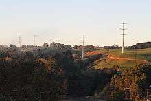
The route
The line commences at a newly constructed substation, Whakamaru North (also known as Whakamaru B), just outside the Whakamaru village. The new substation is 800 metres north of the existing main Whakamaru substation (Whakamaru A). A short tie-line connects the two substations. The double-circuit 220 kV Wairakei to Whakamaru C line, under construction and expected to be commissioned in 2013, will have one circuit connect to each substation, with the circuit passing via Te Mihi connecting to the Whakamaru A switchyard and the direct circuit connecting to the Whakamaru North switchyard.
From Whakamaru, the line travels approximately 186 km north-north-west through the South Waikato, Waipa, Matamata-Piako (passing just west of Morrinsville), Waikato and the Franklin ward of Auckland.The overhead line terminates at a new substation at Brownhill Road, near Whitford, close to the south east Auckland urban boundary. From there, two sets of underground cables connect to Pakuranga substation, which despite the name is near Botany Town Centre in eastern Auckland (the suburb of Pakuranga is 5 km east of the substation). Each cable circuit has a continuous rating of around 660 MVA.[19]
The underground cable route from Brownhill to Pakuranga is 11 km long, and follows Brownhill Road, Sandstone Road and Caldwells Road, weaving through the suburban streets of Dannemora to Te Irirangi Drive until the final approaches to Pakuranga substation.
Sites
- Whakamaru (main) substation: 38°25′09″S 175°48′01″E / 38.41908°S 175.80037°E
- Lake Karapiro/State Highway 1 crossing: 37°57′04″S 175°37′10″E / 37.95117°S 175.61946°E
- State Highway 26 crossing: 37°39′57″S 175°30′19″E / 37.66578°S 175.50534°E
- State Highway 2 crossing: 37°14′46″S 175°11′45″E / 37.24605°S 175.19592°E
- Brownhill Road substation: 36°58′21″S 174°57′40″E / 36.97259°S 174.96113°E
- Pakuranga substation: 36°55′33″S 174°54′24″E / 36.92594°S 174.90666°E
Technical description
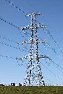
The transmission line is a double circuit line, supported mostly on steel lattice towers. The route length is 186 kilometres (116 mi) and there are 426 structures. The average height of the towers is 60 metres, with some up to 70 metres tall. The average span length between towers is 437 metres, with a maximum span length of 824 metres.[19]
Almost all of the transmission structures are steel lattice towers, but there are seven monopole structures in the Lake Karapiro area (three on the north bank, and four on the south bank). This area had been classified as a Special Landscape Character Area in the Waipa District Plan. The final report of the Board of Inquiry accepted Transpower's proposal to use monopoles instead of lattice towers in this area, and this became a requirement as part of the resource consent conditions for the project.[20]
The transmission line uses a bundled arrangement of three conductors (called a Triplex arrangement) in each phase of each circuit. The conductor type is an All Aluminium Alloy Conductor (AAAC) with a code name of Sulphur. The composition of the aluminium alloy 1120 used in Sulphur conductor includes copper, manganese, magnesium, zinc, iron, chromium and silicon. Conventional transmission line conductors used historically in New Zealand are aluminium conductor steel reinforced (ACSR). The major advantage of the all aluminium alloy conductor over ACSR is its superior strength to weight ratio and its lower electrical resistance for the same cross-sectional area. This leads to lower costs for the transmission line structures, and lower electrical losses over the lifetime of the conductor. AAAC conductors also have superior corrosion resistance when compared with ACSR.[21]
A Sulphur conductor is a stranded AAAC consisting of 61 strands, each of 3.75 mm diameter, with a nominal cross sectional area of 673 square millimetres (1.043 sq in). The overall diameter of each conductor is approximately 33.8 millimetres (1.33 in).[22] The design capacity of the new line, when operating at 400 kV, will be 2700 MVA per circuit,[19] At 220 kV, the circuits will normally operate at 851/890 MVA (summer/winter),[4] with the capacity to operate up to 1490 MVA during contingencies.
The cables in the underground section from Brownhill Road to Pakuranga are each around 160 millimetres (6.3 in) in diameter, and weigh 40 kilograms per metre (81 lb/yd). Each cable circuit comprises three cables. The rating of each cable circuit is 660 MVA.
The project included the removal of the 145 km long Arapuni-Pakuranga 110 kV transmission line first built in 1940, requiring the removal of 460 towers.
Controversy and protest
The regulatory process for investment approval for the project created significant tension between Transpower and the Electricity Commission, and led to political pressure for progress to ensure the security of electricity supply to Auckland. Roy Hemmingway was the Electricity Commissioner at the time.
In April 2006, the Electricity Commission announced an intention to decline Transpower's investment proposal, on the grounds that it was not the most cost-effective solution.[7] However, on 12 June 2006, the vulnerability of power supply to Auckland was revealed when a major transmission failure occurred at Otahuhu substation, leading to the 2006 Auckland Blackout. It started at 8:30 am local time, with most areas of Auckland regaining power by 2:45 pm local time. It affected some 230,000 customers representing at least 700,000 people in and around the city.
Later in June 2006, Hemmingway and other commission members met Energy Minister David Parker, Finance Minister Michael Cullen and senior Transpower executives, and were told to reach an agreement. Hemmingway was not re-appointed when his term expired, and on his departure expressed frustration at the political involvement in the regulatory process.[23]
There were strong protests against the proposed transmission line during the initial planning and regulatory approval process. Many individuals and communities living near the proposed route expressed concerns about the visual effect of the line, possible health effects, and the devaluation of their properties. A particular point of concern was that the proposed transmission towers were to be up to 70 metres (230 ft) in height.
On 24 February 2005, protestors stormed out of a public meeting in Tirau, and effigies of the Transpower CEO Ralph Craven and Prime Minister Helen Clark were burnt in the street.[24]
At a later stage in the approval process, the deputy Commissioner of the Electricity Commission was sworn at and abused at a public meeting in Hamilton in February 2007.[25]
A large number of submissions opposing the project were made to the Electricity Commission in writing or in presentations at public conferences held by the Commission in May 2007.[26]
In November 2007, a group called New Era Energy announced that it would seek a judicial review of the decision by the Electricity Commission to approve the project.[27]
The Board of Inquiry established to consider the designations and resource consents for the project received a total of 1244 submissions. Of these, 1160 were opposed to the project.[28]
Even after September 2009, when the Board of Inquiry gave final approval for the designations and resource consents for the project, many directly affected people were still protesting against the project.[29] Some protests against the transmission line continued during the construction period.[30]
However, ultimately, landowners with lines on or over their property settled agreements with Transpower. In the Annual Report for 2010–2011, Transpower recorded that easements had been obtained on all the 318 properties crossed by the new line, without Transpower having to use powers of compulsory acquisitions.[31]
Land purchases
Transpower purchased a large number of properties from owners to enable the creation of easements that would allow the line to be constructed. Many of the larger properties were dairy farms, and these were bought at a time of high dairy commodity prices. Transpower recorded losses in the value of these properties of approximately $30 million in one year and $20 million in the subsequent year resulting from a decline in dairy commodity prices. [32]
See also
- Overhead power line
- High-voltage cable
- National Grid (New Zealand)
- Electricity sector in New Zealand
- Electric power transmission
References
- ↑ "North Island Grid Upgrade - Resources". Transpower. Retrieved 3 September 2012.
- 1 2 "Transpower $30M over budget on North Island Upgrade". Scoop (website). 18 May 2012. Retrieved 19 May 2012.
- ↑ "Auckland region population projections 2006 - 2051" (PDF). Auckland Regional Council. Retrieved 14 April 2012.
- 1 2 3 "2012 Annual Planning Report – Chapter 6 Grid Backbone" (PDF). Transpower. March 2012. Retrieved 14 April 2012.
- ↑ "Investment Proposal North Island Upgrade Project – May 2005" (PDF). Transpower New Zealand. May 2005. Retrieved 14 April 2012.
- ↑ "2005 Grid Upgrade Plan". Electricity Commission. 30 September 2005. Retrieved 14 April 2012.
- 1 2 "Original Auckland 400 kV grid investment proposal - history - Draft decision". Electricity Commission. 27 April 2006. Retrieved 14 April 2012.
- ↑ "Transpower's 20 October 2006 proposal". Electricity Commission. 20 October 2006. Retrieved 14 April 2012.
- ↑ "NIGU Consultation - archive". Transpower New Zealand. 27 May 2007. Retrieved 14 April 2012.
- ↑ "North Island grid investment proposal - archive - Final decision". Electricity Commission. 3 July 2007. Retrieved 14 April 2012.
- ↑ "Board of inquiry to make decision on Transpower line". Stuff.co.nz. 9 August 2007. Retrieved 14 April 2012.
- ↑ "Public urged to get familiar with Transpower proposal". NZ Government. 22 August 2007. Retrieved 14 April 2012.
- 1 2 "Board of Inquiry Upper North Island Grid Upgrade Proposal – Hearing Information". Ministry for the Environment. Retrieved 14 April 2012.
- ↑ "High Court decision supports grid upgrade process". Scoop.co.nz. 4 May 2009. Retrieved 14 April 2012.
- 1 2 "Board of Inquiry Upper North Island Grid Upgrade Proposal – Report and Decision". Ministry for the Environment. Retrieved 14 April 2012.
- ↑ "Transpower's tower of power". Stuff.co.nz. 4 May 2010. Retrieved 14 April 2012.
- ↑ "New Zealand's largest stringing operation starts". Transpower. 27 October 2011. Retrieved 14 April 2012.
- ↑ Carson, Jonathan (10 May 2012). "Hinuera district up for planned power cut". The Waikato Times (via Stuff.co.nz). Retrieved 19 May 2012.
- 1 2 3 "North Island Grid Upgrade Project Fact Sheet" (PDF). Transpower. Retrieved 14 April 2012.
- ↑ "Report and Decision of the Board of Inquiry into the Upper North Island Grid Upgrade Project: Chapter 10 - Landscape and visual effects; clauses 1067-1138". Ministry for the Environment. Retrieved 3 May 2012.
- ↑ "Statement of Evidence of Milind Vishnu Khot for Transpower New Zealand" (PDF). Ministry for the Environment. Retrieved 2 May 2012.
- ↑ "Aerial AAAC/1120" (PDF). General Cable - New Zealand. Retrieved 2 May 2012.
- ↑ "I'm sorry I took the job, says Roy Hemmingway". NZ Herald. 10 November 2006. Retrieved 14 April 2012.
- ↑ "Power protestors storm out of meeting". NZ Herald. 25 February 2005. Retrieved 14 April 2012.
- ↑ "Waikato farmers deaf to pylon logic". NZ Herald. 1 March 2007. Retrieved 14 April 2012.
- ↑ "North Island grid investment proposal – archive: Written submissions and public conference process - history". Electricity Commission. May 2007. Retrieved 14 April 2012.
- ↑ "Farmers and lifestylers digging deep to continue battle against pylons". NZ Herald. 23 November 2007. Retrieved 14 April 2012.
- ↑ "Transpower Upper North Island Grid Upgrade Proposal - List of Submissions". Ministry for the Environment. Retrieved 14 April 2012.
- ↑ "Protests against Transpower line continue". TVNZ. 19 September 2009. Retrieved 14 April 2012.
- ↑ "Power pylons ruin dreams of paradise on lifestyle blocks". NZ Herald. 20 February 2012. Retrieved 14 April 2012.
- ↑ "Annual Report 2010/11". Transpower. September 2011. Retrieved 14 April 2012.
- ↑ "Transpower loses $20m on farm assets". NZ Herald. 17 August 2011. Retrieved 24 April 2012.
External links
- North Island Grid Upgrade - Resources Transpower New Zealand
- North Island Grid Investment Proposal - Archive Electricity Authority
- Board of Inquiry Upper North Island Grid Upgrade Proposal Ministry for the Environment
- The Waikato pylon war Energy NZ Vol.4 No.5 September–October 2010