Wetumpka, Alabama
| Wetumpka, Alabama | |
|---|---|
| City | |
 | |
| Nickname(s): City of natural beauty | |
 Location in Elmore County and the state of Alabama | |
| Coordinates: 32°32′27″N 86°12′28″W / 32.54083°N 86.20778°W | |
| Country | United States |
| State | Alabama |
| County | Elmore |
| Government | |
| • Type | Mayor/Council |
| • Mayor | Jerry Willis |
| Area | |
| • Total | 10.5 sq mi (27.2 km2) |
| • Land | 10.1 sq mi (26.2 km2) |
| • Water | 0.4 sq mi (1.0 km2) |
| Elevation | 185 ft (56 m) |
| Population (2010) | |
| • Total | 6,528[1] |
| • Density | 645/sq mi (249.2/km2) |
| Time zone | Central (CST) (UTC-6) |
| • Summer (DST) | CDT (UTC-5) |
| ZIP codes | 36092-36093 |
| Area code(s) | 334 |
| FIPS code | 01-81720 |
| GNIS feature ID | 0155305 |
| Website |
www |
Wetumpka is a city in and the county seat of Elmore County, Alabama, United States. At the 2010 census the population was 6,528.[1][2] In the early 21st century, Elmore County, long a rural area, became one of the fastest-growing counties in the state.[3] The city is considered part of the Montgomery Metropolitan Area.
Wetumpka identifies as "The City of Natural Beauty". Among the notable landmarks are the Wetumpka crater and the Jasmine Hill Gardens, with a full-sized replica of the Temple of Hera of Olympia, Greece. Historic downtown Wetumpka was developed on both sides of the Coosa River, and Fort Toulouse was built near it.
Etymology
The name Wetumpka is a historic Creek place word meaning "rumbling waters", supposedly a description of the sound of the nearby Coosa River as the water falls over the rapids of the Devil's Staircase. It could be heard for miles before the construction of dams. The Creek named Wetumka, Oklahoma, after their historic village after being forced west to Indian Territory (present-day Oklahoma), by United States soldiers under the Indian Removal Act of 1830.
History
The area around Wetumpka was the heart of the Upper Creek lands, whose largest towns were located on the banks of the Coosa and at its confluence with the Tallapoosa River, at Wetumpka and Talisi (now Tallassee), respectively.
French and British colonization

After moving the 1702 settlement of Mobile to Mobile Bay in 1711, Jean-Baptiste Le Moyne, Sieur de Bienville sent an expedition up the Alabama River to establish a fort in the interior of New France, both to stop the encroachment of the British and to foster trade and goodwill with the Creek.

He had Fort Toulouse constructed on the Coosa River in 1714, 4 miles (6 km) above the confluence of the Coosa and Tallapoosa rivers at the Creek village of Taskigi. Bienville selected this area as a strategic locale for a fortification.
The French traded at Wetumpka and garrisoned Fort Toulouse until 1763, when they ceded the territory to the British following defeat in the Seven Years' War (known as the French and Indian War in North America).
United States rule
After Britain was defeated in the American Revolutionary War, it ceded the territory east of the Mississippi River to the United States in 1783. In 1798 the US made this area part of the Mississippi Territory, after cessions from the states of Georgia and South Carolina. Between 1800 and 1812, pioneers began to arrive and encroach on the lands of the Southeast Indian tribes. Several Scots and Irish traders, such as McGillivray and Weatherford, had earlier married into the Creek matrilineal aristocracy and claimed vast land grants.
By the early 19th century, there were tensions among the Creek, with young men of the Upper Creek promoting a revival of religion and culture, and the Lower Creek, more influenced by settlement and trade with European Americans in Georgia, becoming more assimilated. In addition, in 1811, the Shawnee chief Tecumseh of the upper Northwest appealed to the Creek to join his Western Confederacy to try to drive out and exterminate the European settlers.
When the U.S. declared war on Britain in June 1812, the Upper Creek lost the assistance of the British, but they persisted with war against American settlers in the area. Upon receiving the news of the massacre at Fort Mims, whose refugees included many Lower Creek, American settlers appealed for government help. General Andrew Jackson led a militia with members from Tennessee, Mississippi, and Georgia and attacked the Creek in Alabama. The path the militia traveled became known as "Jackson's Trace".
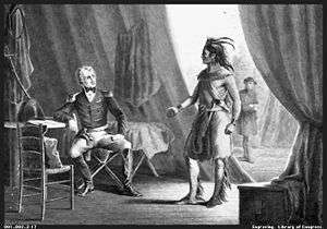
Jackson's forces won a decisive victory at the Battle of Horseshoe Bend. He moved on to Fort Toulouse, where he directed its repair. During his absence, the site was renamed Fort Jackson in his honor.
Jackson made the fort his headquarters during the War of 1812, and the newly created Montgomery County held its courts there. The defeated Creek were forced to sign the Treaty of Fort Jackson (1814), which ceded to the United States 23,000,000 acres (36,000 sq mi; 93,000 km2) of Creek lands: much of the remainder of their territory in Georgia and most of central Alabama. After the war, many of Jackson's Tennessee militia returned home, collected their families and belongings, and brought them back to settle near the fort.
Growth and incorporation
Settlers, mostly from Georgia and the Carolinas, flooded into the fertile land that the Creeks had been forced to abandon. With its strategic location at the river confluence, Wetumpka quickly became an important center of agricultural trade. The city was formally incorporated in 1834. Cotton was the commodity crop of the new state of Alabama, with cultivation of short-staple cotton in the upland areas made possible by Eli Whitney's invention of the cotton gin, which reduced the labor of processing. From the scattered fields and large plantations worked by slave labor in the interior, cotton was carted overland to Wetumpka. Located at the fall line of the Coosa River, the port shipped out cotton bales by steamboats which went downriver to the markets at Mobile for sale.

Wetumpka became a cotton boom town. The new city was divided in half. The part of the city on the eastern bank of the river was commercial, with banks, stores, and hotels, and was located in Coosa County. The western section in Autauga County was residential, with houses and churches laid out on a grid pattern of streets.
By 1836, the city's population was 1,200. New York's Harper's Weekly declared that "Wetumpka, Alabama and Chicago, Illinois are the most promising two cities of the West." The city commissioned a steamboat, The Coosa Belle, to ferry passengers and cotton between Wetumpka and Mobile.
The same forces contributing to Wetumpka's growth were shifting the balance of power within Alabama. A standoff between the farmers of the Tennessee Valley, centered in the former capital of Huntsville, and the old mercantile wealth of Mobile, had resulted in the capital being located for many years at Tuscaloosa. By 1845, the cotton planters in the interior Black Belt had become some of the wealthiest in the country, and power was shifting toward the southern and central part of the state. Both the Black Belt cotton barons and the Mobilians wanted the capital moved.
Compromise indicated a new, centrally located capital, accessible by river and by steamboat. The lead contenders were Wetumpka and the newer city of Montgomery, a few miles south. Neither city had a majority of support; representatives from north Alabama, enraged that the capital was being moved from Tuscaloosa, were indifferent to either site. Just before the vote, Montgomery lured an expensive French chef to the new hotel they had built to house the state's representatives if Montgomery were selected. The city distributed elegant menus to the statesmen. The promise of luxury swayed the vote, and Montgomery won. That same year, a fire broke out in Wetumpka, burning warehouses and many commercial buildings. The charred bricks were carried downriver to Montgomery to supply the building boom in Alabama's new capital.
War and flood
Though their civic pride was wounded by losing the capital to Montgomery, the planters and merchants of the region continued to flourish throughout the antebellum period. They promoted a plan to build a lock and dam so that boats would be able to pass above the Fall Line and travel up the Coosa as far as Rome, Georgia. One famous resident was William Lowndes Yancey, a firebrand newspaper editor and statesman who was an influential advocate of states' rights and Southern secession.
In February 1861, representatives from seven Southern states met in nearby Montgomery to form the Confederate government, inaugurating Jefferson Davis as their president on the steps of the Alabama state capitol. The first six states to secede were those whose residents owned the most slaves in the South. The same year saw the majority of the male population of Wetumpka going off to war. Wetumpka was never harmed by Federal troops. No Union troops entered the area until early 1865, and they were driven to reach Montgomery to punish the former Confederate capital before the war ended.
Veterans of the war returned to a city and a region whose economy had been completely destroyed. In 1866, a Reconstruction government drew up a new plan of counties for the state, and Elmore County was created out of parts of Coosa, Autauga, and Montgomery counties, with Wetumpka as its county seat. (Rockford was chosen as seat of the "new" Coosa County.)
Despite this, the future of the city seemed grim. Before the war, the population had reached more than 3,000. By 1879, it had declined to 619. In 1886, the worst flood in the history of the city inundated the west bank and most of downtown. The bridge connecting the city's two halves was washed away, and more than a year passed before Wetumpka was able to replace the bridge.
The Lexington Kentucky Morning Herald of October 3rd, 1900, had a rather grim addition to Wetumpka's history:“Negro Burned At Stake” Winfield Townsend, alias Floyd, a negro, was burned at the stake in the little town of Eclectic, 15 miles from Wetumpka, Ala. The negro’s crime was attempted assault on Mrs. Lonnie Harrington, whose husband set fire to the fuel which reduced Townsend’s body to ashes. …..”The dogs stopped at a tree in the outskirts of Eclectic. He was brought down at once and taken to the scene of his crime. The victim identified him. The stake was prepared and the negro bound to it with chains. Pine knots were piled about him the flames was started by the husband of the victim.” [4]
Progress

The first paved road linking Wetumpka with Montgomery was completed in 1924. Montgomery continued to grow during the two World Wars because of military spending in the region and the growth of the state government. By the 1950s, the ubiquity of the automobile allowed Wetumpka's residents to commute daily to Montgomery for work.
Geography
Wetumpka is located southwest of the center of Elmore County at 32°32′27″N 86°12′28″W / 32.54083°N 86.20778°W (32.540972, −86.207726),[5] and sits on both sides of the Coosa River 5 miles (8 km) northeast of its confluence with the Tallapoosa River, where they merge to become the Alabama River.
The city is situated astride the Fall Line, where the Appalachian foothills give way to the flat Gulf Coastal Plain.
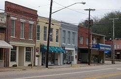
Downtown Wetumpka covers two city blocks, and is bordered on the northwest by the Coosa River. The Bibb Graves Bridge crosses the river here, and is the city's most recognizable landmark. Directly across the bridge are the city's three antebellum churches, the First Methodist, First Presbyterian, and First Baptist.
According to the U.S. Census Bureau, the city has a total area of 10.5 square miles (27.2 km2), of which 10.1 square miles (26.2 km2) is land and 0.39 square miles (1.0 km2), or 3.66%, is water.[6]
Demographics
| Historical population | |||
|---|---|---|---|
| Census | Pop. | %± | |
| 1850 | 3,824 | — | |
| 1870 | 1,137 | — | |
| 1880 | 816 | −28.2% | |
| 1890 | 619 | −24.1% | |
| 1900 | 562 | −9.2% | |
| 1910 | 1,103 | 96.3% | |
| 1920 | 1,520 | 37.8% | |
| 1930 | 2,357 | 55.1% | |
| 1940 | 3,089 | 31.1% | |
| 1950 | 3,813 | 23.4% | |
| 1960 | 3,672 | −3.7% | |
| 1970 | 3,912 | 6.5% | |
| 1980 | 4,341 | 11.0% | |
| 1990 | 4,670 | 7.6% | |
| 2000 | 5,726 | 22.6% | |
| 2010 | 6,528 | 14.0% | |
| Est. 2015 | 7,994 | [7] | 22.5% |
| U.S. Decennial Census[8] 2013 Estimate[9] | |||
As of the census[10] of 2010, there were 6,528 people and 2,206 households residing in the city.[1] The population density was 645 inhabitants per square mile (249.2/km2). There were 2,139 housing units at an average density of 212 per square mile (81.7/km2).[6] The racial makeup of the city was 64.88% White, 32.83% Black or African American, 0.40% Native American, 0.40% Asian, 0.07% Pacific Islander, 1.38% from other races, and 0.94% from two or more races. 2.32% of the population were Hispanic or Latino of any race.[11]
There were 1,797 households out of which 28.0% had children under the age of 18 living with them, 43.1% were married couples living together, 16.5% had a female householder with no husband present, and 37.2% were non-families. 34.2% of all households were made up of individuals and 16.0% had someone living alone who was 65 years of age or older. The average household size was 2.30 and the average family size was 2.97.[11]
In the city the population was spread out with 18.4% under the age of 18, 8.5% from 18 to 24, 36.5% from 25 to 44, 20.6% from 45 to 64, and 16.0% who were 65 years of age or older. The median age was 38 years. For every 100 females there were 62.1 males. For every 100 females age 18 and over, there were 54.2 males.[11]
The median income for a household in the city was $35,536, and the median income for a family was $41,500. Males had a median income of $32,403 versus $23,234 for females. The per capita income for the city was $15,729. About 7.7% of families and 11.7% of the population were below the poverty line, including 19.5% of those under age 18 and 10.7% of those age 65 or over.[11]
Culture, natural history, and recreation
Wetumpka in movies
Three major films have been filmed on location in downtown Wetumpka.
- Big Fish (2003)[12]
- The Grass Harp (1995)[13]
- The Rosa Parks Story (2002)[14]
Wetumpka meteor crater
Wetumpka is the home of "Alabama's greatest natural disaster". A meteorite, estimated to be 1,000 feet (300 m) wide, hit the area about 80 million years ago. The hills just east of downtown showcase the eroded remains of a 5-mile-wide (8 km) impact crater that was blasted into the bedrock, with the area labeled the Wetumpka crater or astrobleme ("star-wound") for the concentric rings of fractures and zones of shattered rock that can be found beneath the surface.[15][16] In 2002, Auburn University researchers published evidence and established the site as an internationally recognized impact crater.[15]
Jasmine Hill Gardens
This outdoor museum was built in the 1930s on the estate of the Fitzpatrick family, who spent many years in Greece collecting replicas of ancient statuary to adorn their formal gardens at Jasmine Hill. Today the gardens are run as a non-profit foundation dedicated to promoting the arts and Greek culture. Frequently the site of local weddings, its attractions include a full-sized replica of the Temple of Hera at Olympia. Jasmine Hill Photo Gallery
Outdoor recreation

Wetumpka and the Coosa River annually play host to the Coosa River Challenge, which began in 2003 and regularly draws 150 to 200 participants. The race, a modified triathlon, starts at the Swayback Bridge Trail with a cross country run, a mountain bike leg, and paddling on the Coosa River to finish at Goldstar Park in downtown Wetumpka.
The Swayback Bridge Trail is home to the annual mountain bike race, "Attack on Swayback".
Wetumpka is popular with white water sports enthusiasts, attracting paddlers from all over the country. The city hosts the annual Coosa River Whitewater Festival, and was the site of the 2005 U.S. Freestyle Kayaking Nationals. The Coosa River Paddling Club has constructed Corn Creek Park, which offers public access to the river, along with nature and walking trails.
Poarch Creek casino
The Poarch Band of Creek Indians, the only federally recognized tribe in Alabama, have built a casino on land abutting the city.[17] The tribe have announced plans for a major expansion of the casino to include a $246 million hotel, a second casino, and many other attractions in the complex as well. The new casino complex will employ over 1,000 people and have a 20-story, 285-room hotel named Wind Creek Wetumpka.[18]
Government and infrastructure
The United States Postal Service operates the Wetumpka Post Office.[19]
The Julia Tutwiler Prison for Women of the Alabama Department of Corrections is located in Wetumpka. The prison houses Alabama's female death row.[20] Wetumpka was previously the site of the Wetumpka State Penitentiary.[21]
Education
The city is within the Elmore County Public School System.
Public schools include Wetumpka Elementary School,[22] Wetumpka Middle School,[23] Wetumpka High School,[24] and Redland Elementary School.[25] Wetumpka Middle School was formed by a merger of Wetumpka Intermediate School and Wetumpka Junior High School.[26]
Notable people
- James Anderson, actor
- William B. Bryant, United States federal judge from 1965 to 2005
- James Daniel, tight end coach for the Pittsburgh Steelers
- John Kelly Fitzpatrick, painter
- Hanley Funderburk, president of Auburn University from 1980 to 1983 and president of Eastern Kentucky University from 1984 to 1998
- Lewis Jackson, head basketball coach of Alabama State University
- Jean Baptiste Louis DeCourtel Marchand, French soldier who died in Wetumpka. Great-grandfather of Creek leader William Weatherford and great-uncle of Alexander McGillivray, also a Creek chief
- Joe McInnes, former director of the Alabama Department of Transportation
- Jason McLaughlin, soccer player
- Charles McMorris, US vice admiral
- Benjamin White Norris, congressman from 1868 to 1869
- Frank Oliver, former National Football League defensive back
- Blake Percival, whistleblower
- Jim Rogers, businessman and author
- Jason Sanford, science fiction author
- Elizabeth Spiers, writer and editor
- Monica Lisa Stevenson, gospel musician
- Tevin Washington, previous starting quarterback for Georgia Tech football team
- Thomas Williams, congressman from 1879 to 1885
- Jamie Winborn, pro football player
- William Lowndes Yancey, Confederate politician and diplomat
Gallery
 The Elmore County Courthouse is located at 100 E Commerce St. in Wetumpka.
 Wetumpka City Hall is located at 212 S. Main Street.
 The Wetumpka Post Office is located at 216 W. Fort Toulouse Rd.
 First United Methodist Church of Wetumpka. Placed on the National Register of Historic Places on February 15, 1973.
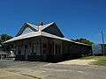 The Wetumpka L&N Depot was built in 1906 and placed on the National Register of Historic Places on July 1, 1975.
 First Presbyterian Church of Wetumpka. Placed on the National Register of Historic Places on October 8, 1976.
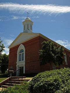 First Baptist Church of Wetumpka. Placed on the National Register of Historic Places on October 24, 2008.
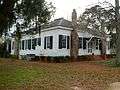 The Abel Hagerty House. Placed on the National Register of Historic Places on January 14, 2008.
 Julia Tutwiler Prison for Women is a maximum security prison located along U.S. Highway 231 in Wetumpka.
Climate
The climate in this area is characterized by hot, humid summers and generally mild to cool winters. According to the Köppen Climate Classification system, Wetumpka has a humid subtropical climate, abbreviated "Cfa" on climate maps.[27]
References
- 1 2 3 http://quickfacts.census.gov/qfd/states/01/0181720.html
- ↑ "Fact Sheet". American Fast Facts- Wedumpka city, Alabama. United States Census Bureau. Retrieved February 9, 2010.
- ↑ "Census Info Shows Growth Rate of Two Alabama Rural Counties Exceeds National Average". Center for Business and Economic Research. University of Alabama. Retrieved February 9, 2010.
- ↑ Lexington Morning Herald, pg. 1, October 3rd, 1900.
- ↑ "US Gazetteer files: 2010, 2000, and 1990". United States Census Bureau. 2011-02-12. Retrieved 2011-04-23.
- 1 2 "Geographic Identifiers: 2010 Demographic Profile Data (G001): Wetumpka city, Alabama". American Factfinder. U.S. Census Bureau. Retrieved January 20, 2016.
- ↑ "Annual Estimates of the Resident Population for Incorporated Places: April 1, 2010 to July 1, 2015". Retrieved July 2, 2016.
- ↑ "U.S. Decennial Census". Census.gov. Retrieved June 6, 2013.
- ↑ "Annual Estimates of the Resident Population: April 1, 2010 to July 1, 2013". Retrieved June 3, 2014.
- ↑ "American FactFinder". United States Census Bureau. Retrieved 2008-01-31.
- 1 2 3 4 "Fact Sheet". American Fast Facts- Wedumpka city, Alabama. United States Census Bureau. Retrieved February 9, 2010.
- ↑ "Big FIsh (2003)". IMDb.com, Inc. Retrieved 9 February 2010.
- ↑ "The Grass Harp (1995)". IMDb.com, Inc. Retrieved 9 February 2010.
- ↑ "The Rosa Parks Story (2002)". IMDb.com, Inc. Retrieved June 9, 2010.
- 1 2 "Wetumpka Impact Crater" Wetumpka Public Library, accessed August 21, 2007.
- ↑ "The Wetumpka Astrobleme" by John C. Hall, Alabama Heritage, Fall 1996, Number 42.
- ↑ "Creek Casino Wetumpka". Poarch Band of Creek Indians. Retrieved March 9, 2013.
- ↑ Mitchell, Ellen (11 July 2012). "Poarch Creeks plans second mega casino in Wetumpka". Press-Register.
- ↑ "Post Office Location – WETUMPKA." United States Postal Service. Retrieved on September 6, 2010.
- ↑ "Annual Report Fiscal Year 2003." Alabama Department of Corrections. 45/84. Retrieved on August 15, 2010. "Tutwiler also has a death row,"
- ↑ "ADOC History." Alabama Department of Corrections. Retrieved on September 6, 2010.
- ↑ "Home." Wetumpka Elementary School. Retrieved on June 3, 2013.
- ↑ "Home." Wetumpka Middle School. Retrieved on June 3, 2013.
- ↑ "Home." Wetumpka High School. Retrieved on June 3, 2013.
- ↑ ""
- ↑ "Montgomery and Elmore County Schools Moving Forward with Building Plans." (Archive) WSFA-TV. January 23, 2008. Retrieved on June 3, 2013.
- ↑ Climate Summary for Wetumpka, Alabama
External links
| Wikimedia Commons has media related to Wetumpka, Alabama. |
- City of Wetumpka official website
- WetumpkaOnline
- Elmore County Tourism Council
- Elmore County Economic Development Authority (ECEDA)
- Wetumpka City Pages
- Wetumpka Public Library
- Jerry Armstrong's pictures of the Wetumpka impact crater
Coordinates: 32°32′27″N 86°12′28″W / 32.540972°N 86.207726°W
Municipalities and communities of Elmore County, Alabama, United States | ||
|---|---|---|
| Cities | 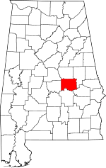 | |
| Towns | ||
| CDPs | ||
| Unincorporated communities | ||
| Footnotes | ‡This populated place also has portions in an adjacent county or counties | |