Wetteraukreis
| Wetteraukreis | |
|---|---|
| District | |
 | |
| Country |
|
| State | Hesse |
| Adm. region | Darmstadt |
| Capital | Friedberg |
| Area | |
| • Total | 1,101.71 km2 (425.37 sq mi) |
| Population (31 December 2015)[1] | |
| • Total | 301,931 |
| • Density | 270/km2 (710/sq mi) |
| Time zone | CET (UTC+1) |
| • Summer (DST) | CEST (UTC+2) |
| Vehicle registration | FB, BÜD |
| Website | http://www.wetteraukreis.de |

Area view of Eckartshausen
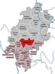
The Wetteraukreis is a Kreis (district) in the middle of Hesse, Germany. Neighbouring districts are Landkreis Gießen, Vogelsbergkreis, Main-Kinzig-Kreis, district-free Stadt Frankfurt, Hochtaunuskreis and Lahn-Dill-Kreis.
History
The district was created in 1972 when the two districts Friedberg and Büdingen were merged.
Geography
The district is located between the Taunus mountains and the Vogelsberg volcanic mountain. The main rivers of the district are the Nidda River and the Wetter River.
Coat of arms
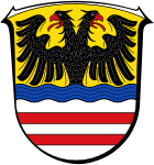 |
The imperial eagle in the top of the coat of arms was chosen because the Wetterau was imperial possession in the past. The bars in the bottom derive from the lords of Isenburg-Büdingen, who owned most of the area. The wavy line depicts the river Wetter which flows through the capital Friedberg. |
Towns and municipalities
| Towns | Municipalities |
|---|---|
References
- ↑ "Bevölkerung der hessischen Gemeinden". Hessisches Statistisches Landesamt (in German). August 2016.
External links
![]() Media related to Wetteraukreis at Wikimedia Commons
Media related to Wetteraukreis at Wikimedia Commons
- Official website (German)
Coordinates: 50°22′N 8°55′E / 50.367°N 8.917°E
This article is issued from Wikipedia - version of the 6/22/2015. The text is available under the Creative Commons Attribution/Share Alike but additional terms may apply for the media files.