Westwood Quarry
| Site of Special Scientific Interest | |
 | |
| Area of Search | Hertfordshire |
|---|---|
| Grid reference | TQ071993 |
| Interest | Geological |
| Area | 0.07 hectares |
| Notification | 1987 |
| Location map | Magic Map |
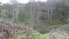
Westwood Quarry is a 0.07 hectare (0.18 acre) is a geological site of Special Scientific Interest west of Watford in Hertfordshire. The site was notified in 1987 under the Wildlife and Countryside Act 1981. The planning authority is Three Rivers District Council.[1][2] It is a Geological Conservation Review site.[3]
It is described by Natural England as a key site for the early history of the River Thames as it provides the best known exposure of the "Lower Gravel Train", a deposit laid down when the Thames flowed through the Vale of St Albans, before it was diverted south to its present course during the Anglian Ice Age around 450,000 years ago.[1][4]
The site is private land with no public access.
| Wikimedia Commons has media related to Westwood Quarry. |
See also
References
- 1 2 "Westwood Quarry citation" (PDF). Sites of Special Scientific Interest. Natural England. Retrieved 9 December 2014.
- ↑ "Map of Westwood Quarry". Sites of Special Scientific Interest. Natural England. Retrieved 9 December 2014.
- ↑ "Westwood Quarry (Quaternary of the Thames)". Joint Nature Conservation Committee. Retrieved 12 January 2016.
- ↑ "A Geological Conservation Strategy for Hertfordshire" (PDF). Herts RIGS Group. 2003. p. 43.
Coordinates: 51°40′56″N 0°27′08″W / 51.68226°N 0.45227°W