Territorial evolution of the United States
The United States of America was created on March 1, 1781, with the entry into force of the Articles of Confederation. In its history, it has gained independence from Great Britain, replaced its government with a new constitution, endured a civil war, and expanded across North America and the seas, growing from thirteen states to fifty states and many territories from the western Pacific Ocean to the Caribbean Sea.
Notes
- "Unorganized territory" is not a name; it simply means that Congress has not passed an organic act for the territory or it does not otherwise have a name. In most situations, the purpose of unorganized territory was to act as land for Native American settlement. Indeed, the last mainland unorganized territory was colloquially referred to as "Indian Territory." All land ceded to the federal government without an official name is labeled as "Unorganized territory".
- This article includes all territories, unincorporated and incorporated, that the United States has possessed or claimed throughout its history, with the following notes:
- While the United States occupied Cuba for a time, it was not ceded to the United States after the Spanish-American War nor ever claimed by it.
- Wartime and post-war occupations by the United States of foreign territory are not noted unless they involved formal annexation. For example, the United States military occupied several countries in Central America and the Caribbean for many years during the Banana Wars, but, as there was no annexation, this is not noted. Furthermore, while there was a civil government created for some areas after World War II, such as the United States Civil Administration of the Ryukyu Islands from 1953 to 1972 or the American zones of occupation in southwest Germany, West Berlin, and Austria, these were never considered part of the United States and are omitted.
- Wartime occupations of American territory are noted only when a substantial replacement of the local government was involved, or an entire territory had surrendered. For example, during World War II, the Philippines had a separate government administering it, while the captured Aleutian Islands were small military occupations. Likewise, the regaining of lost territory by the United States is only noted if the territory was earlier noted as being lost or if it was returned following the end of hostilities, such as through a treaty; thus, the recapture of the Aleutian Islands during World War II is not noted, but the cession of islands off Maine after the War of 1812 is.
- Islands claimed under the Guano Islands Act had varying amounts of control and claims from other countries. Though the United States and United Kingdom may have claimed the islands on paper, many were uninhabited and generally ignored once the guano miners left. The names given for guano islands are generally the modern names, as the islands had many names based on multiple sightings and claims, and, since many were uninhabited, there was no local name.
- Maps:
- The maps are concerned only with the official definition of the United States by itself and with any claims and controls by foreign powers, so proposed states or temporary territories, such as the State of Deseret, Jefferson Territory, or New Mexico under Stephen Kearny, are listed as changes and mapped, but they are omitted from the evolving map of the country.
- The maps are of the changes to the United States in central North America (the current contiguous United States), as defined by the United States (meaning the maximal borders are used in the case of a dispute), unless otherwise specified. Overlaps in definitions, active border disputes between parts of the United States, or disagreements between one part of the United States and the federal government over a part of the international border (the main example being the claim by Arkansas Territory of an area of Mexico without permission from the federal government) are shown in the maps as red areas. If an area is ambiguous or challenged but not actively pursued (like The Wedge), it is noted in the table of changes but not shown in the main map.
- When relevant, maps of the changes to international disputes involving the United States are displayed, including the undisputed areas of the country and any areas claimed by others, with the requirement that the other country must be internationally recognized or be the sole civil government in any part of the United States.
- Due to the lower complexity, maps of the changes to the United States in the Pacific Ocean, the Caribbean Sea, or northwestern North America include any disputes.
- Dates are given in local time. This only matters for some changes in the mid-Pacific. For example, Guam surrendered on the morning of December 10, 1941, which was December 9 in the mainland United States.
Table of changes
- Key to map colors
- disputed area of United States
- undisputed area of United States (outline view in maps of international disputes; internal view in domestic maps)
- United States territories (domestic maps)
- area changed by event
- Click on any map to view a larger version in Wikimedia Commons. Click on that Commons map to further enlarge map details.
| Date | Event | Change Map |
|---|---|---|
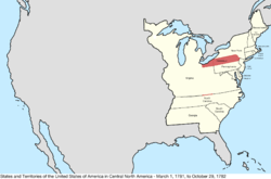
| March 1, 1781 | The Articles of Confederation entered into force, creating the United States of America.[1] The capital was not specifically established; at the time, the Congress of the Confederation met in Philadelphia.[2]
Many states had vaguely defined and surveyed borders; these are not noted as contested in the maps unless there was an active dispute. The borders of North Carolina were particularly poorly surveyed, its border with South Carolina having been done in several pieces, none of which truly matched the spirit of the charter,[3][4] and its border with Virginia surveyed by North Carolina only as far as the Cumberland Gap, but by Virginia to the Tennessee River, creating a thin area claimed by both states (the two surveys being roughly two miles apart). Since the dispute with Virginia only technically went as far west as the Cumberland Gap, beyond that point North Carolina's line is faded to show that it was more an assumption. While the border was intended to follow 36°30′ north, early surveying errors caused it to veer north of that, reaching a distance of seventeen miles off by the time it reached the Tennessee River.[5] Several northeastern states had overlapping claims: Connecticut, Massachusetts, and New York all claimed land west of their borders, overlapping with each other and with a sizeable claim by Virginia. Of these, however, only that of Connecticut was seriously pursued, though Virginia is considered to have had the most legitimate claim to the vast northwest, which they divided into counties and over which it maintained some limited control. The entirety of the new United States was claimed by Great Britain, and the northeastern area of New York was claimed by the Vermont Republic. Of particular note are Machias Seal Island and North Rock, two small islands off the northeast coast which remain disputed up to the present. |
 Disputes:
|
| April 4, 1781 | The Vermont Republic claimed what was called the "East Union," consisting of some towns in New Hampshire, while never gaining control over the area.[6][7][8][9] | Disputes: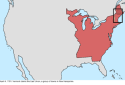 |
| June 16, 1781 | The Vermont Republic claimed what was called the "West Union," consisting of some additional towns in New York, while never gaining control over the area.[7][8][10][11] (The specific date this occurred is unclear; sources suggest June 16, June 26, and July 18). | Disputes: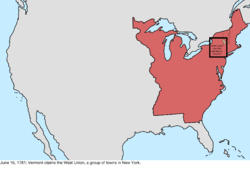 |
| February 22, 1782 | The Vermont Republic abandoned its attempts to annex the East Union from New Hampshire and the West Union from New York.[8][9][11][12] | Disputes: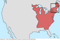 |
| October 29, 1782 | The federal government accepted the cession from New York of its western claims on February 17, 1780. At its maximum interpretation, New York had claimed an area bordered by Lake Erie, Lake Huron and Lake Michigan, to the Illinois River, to the Mississippi River, to the Tennessee River and north again along the Appalachian Mountains, ending again at the border with Pennsylvania. It is unclear from where this claim came; many sources state that New York had surrendered it, but very few elaborate on how it was obtained. One source states that it was a cession by the Six Nations, who had conquered much of the region.[13] These claims, however, were never seriously enforced. Also ceded was the western tip of the state, the Erie Triangle.[14][15] | 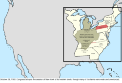 |
| December 30, 1782 | The Congress of the Confederation declared that the land that Connecticut has claimed in northeast Pennsylvania (and, unknown at the time, a small sliver of New York) was part of Pennsylvania, thus attempting to end the Pennamite–Yankee War.[16] While conflict would continue for some time, this was the end of formal claims by either state government. | 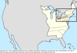 |
| June 30, 1783 | The Congress of the Confederation begins meeting in Princeton, thus making it the de facto capital.[2] | no change to map |
| November 26, 1783 | The Congress of the Confederation begins meeting in Annapolis, thus making it the de facto capital.[2] | no change to map |
| March 1, 1784 | Virginia ceded its western claims to the federal government, while[17][18] Connecticut continued its western claims that had overlapped those of Virginia. | 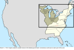 |
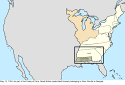
| May 12, 1784 | Great Britain recognized the independence of the United States, ending its claim to the country,[19] though borders with Great Britain were poorly defined in several areas in the north of the country.
The Peace of Paris also involved treaties with France and Spain. In particular, Great Britain ceded the Floridas to Spain. During the ownership by Great Britain over West Florida, it had moved the border north, and the cession appeared to apply to the full extent of the British colony, which conflicted with the terms of the British-American treaty. The local Spanish governors also made a move to occupy forts along the Mississippi River, with claims to everything south of the Tennessee River; it is unknown how official or strong these claims were, and these claims are not mapped as they are in conflict with the other Spanish claim involving the border of West Florida.[20] |
 Disputes: 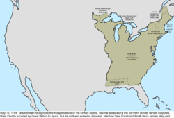 |
| August 23, 1784 | Representatives of several counties in western North Carolina, unhappy with the state's governance over the area, declared independence from the state as the State of Franklin.[21] The government of Franklin held some control over the area, and even petitioned for statehood, but would only last a few years. | Unofficial change: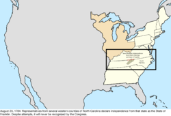 |
| November 1, 1784 | The Congress of the Confederation begins meeting in Trenton, thus making it the de facto capital.[2] | no change to map |
| January 11, 1785 | The Congress of the Confederation begins meeting in New York, thus making it the de facto capital.[2] | no change to map |
| April 19, 1785 | The federal government accepted the cession from Massachusetts of its extreme western claims, which consisted of a strip of land west of Lake Huron and the Detroit River, bounded on the north by a line extending west from roughly halfway north through New Hampshire, and on the south by a line extending from the southern border of Massachusetts in its western half. These claims were never seriously enforced, however.[22] | Change on paper only: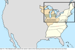 |
| September 13, 1786 | Connecticut surrendered most of its western claims to the federal government, though it is unclear if control over the region was ever actually held.[23][24] | Change on paper only: |
| December 16, 1786 | Massachusetts surrendered its claim to western New York, though it is unclear if Massachusetts ever held control over the region.[22] This land was later known as the Phelps and Gorham Purchase. | Change on paper only: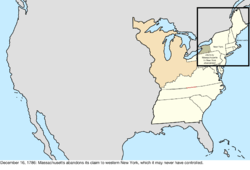 |
| July 13, 1787 | The Northwest Ordinance organized the territory northwest of the Ohio River into the Northwest Territory.[25] | 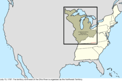 |
| August 9, 1787 | South Carolina ceded its western claims to the federal government,[26] though these were a result of incorrect surveying, with South Carolina never actually holding claim to this land. This was unknown at the time, however, and the eastern part of this cession would be given to Georgia in 1802, despite Georgia technically already having claim to that land. | Change on paper only: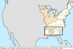 |
| December 7, 1787 | Delaware became the first state to ratify the United States Constitution.[27] | no change to map |
| December 12, 1787 | Pennsylvania became the second state to ratify the Constitution.[28] | no change to map |
| December 18, 1787 | New Jersey became the third state to ratify the Constitution.[29] | no change to map |
| January 2, 1788 | Georgia became the fourth state to ratify the Constitution.[30] | no change to map |
| January 6, 1788 | Connecticut became the fifth state to ratify the Constitution.[31] | no change to map |
| February 6, 1788 | Massachusetts became the sixth state to ratify the Constitution.[32] | no change to map |
| April 28, 1788 | Maryland became the seventh state to ratify the Constitution.[33] | no change to map |
| May 23, 1788 | South Carolina became the eighth state to ratify the Constitution.[34] | no change to map |
| June 21, 1788 | New Hampshire became the ninth state to ratify the Constitution;[35] at this point, the Constitution became the active governing document of the country. | no change to map |
| June 25, 1788 | Virginia became the tenth state to ratify the Constitution.[36] | no change to map |
| July 26, 1788 | New York became the eleventh state to ratify the Constitution.[37] | no change to map |
| February 1789 | John Sevier, governor of the State of Franklin, pledged allegiance to North Carolina, effectively ending the claimed independence of Franklin.[38] | no change to map |
| August 7, 1789 | The Northwest Territory was reorganized under the Constitution.[39] | no change to map |
| November 21, 1789 | North Carolina became the twelfth state to ratify the Constitution.[40] | no change to map |
| April 2, 1790 | North Carolina ceded its western counties to the federal government.[41][42] | 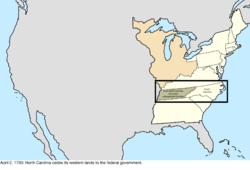 |
| May 26, 1790 | The land ceded by North Carolina was organized as the Territory South of the River Ohio, commonly known as the Southwest Territory.[42][43] | 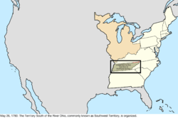 |
| May 29, 1790 | Rhode Island became the thirteenth state to ratify the Constitution.[44] | no change to map |
| December 6, 1790 | The Congress of the United States begins meeting in Philadelphia, thus making it the de facto capital.[2] | no change to map |
| March 4, 1791 | Vermont, which had been considered part of New York despite acting independently since 1777, was admitted as the fourteenth state, New York having consented to the admission of Vermont in 1790.[8][45] Being admitted to the Union, Vermont no longer disputed any territory with the United States. | 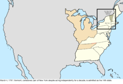 Disputes: 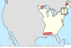 |
| March 30, 1791 | The District of Columbia was formed from land ceded by Maryland and Virginia.[46][47] It was not, however, yet given that name, being simply referred to as the federal district. In September 1791, the commissioners in charge of planning the city would term it the "Territory of Columbia", and various laws refer to a District of Columbia, but sometimes informally. The area does not appear to have been formally named "District of Columbia" until at least the organic act of 1871.[48] However, since the name "Columbia" was used from very early on, and at least informally by the government, the map will use "District of Columbia" starting from this date. |  |
| March 3, 1792 | Pennsylvania purchased the Erie Triangle from the federal government.[49] | 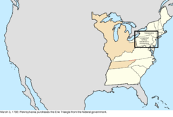 |
| June 1, 1792 | The western counties of Virginia, which the state had agreed in 1789 to cede to the federal government,[50] were admitted as the fifteenth state, Kentucky.[51][52] | 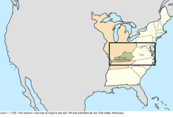 |
| February 29, 1796 | Great Britain agreed to abandon several forts in the northwest that it still occupied, including Detroit.[53] | no change to map |
| April 25, 1796 | The northern half of West Florida was ceded by Spain, resolving the dispute over the region.[54][55] | Disputes: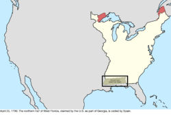 |
| June 1, 1796 | Southwest Territory was admitted as the sixteenth state, Tennessee.[42][56] | 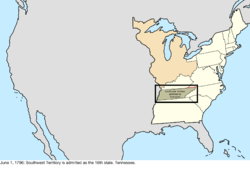 |
| April 7, 1798 | Due to the Yazoo Land Fraud, an act was signed by President John Adams authorizing him to appoint commissioners to negotiate with Georgia about ceding its western land. The act also created Mississippi Territory from the southwestern quarter of Georgia in the region recently ceded by West Florida while maintaining that Georgia still held rights over the territory.[57][58] | 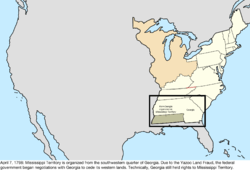 |
| July 4, 1800 | Indiana Territory was organized from the western bulk of Northwest Territory.[59][60] | 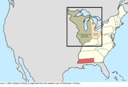 |
| November 17, 1800 | The Congress of the United States moved to Washington, now ready to be the capital.[2] | no change to map |
| January 1, 1801 | The Kingdom of Great Britain united with the Kingdom of Ireland, renaming itself the United Kingdom.[61] |  |
| February 27, 1801 | The District of Columbia was organized.[47][62] | no change to map |
| March 2, 1801 | Connecticut ceded the Western Reserve to the federal government, which assigned it to Northwest Territory.[63] The act doing so was passed in Congress on April 28, 1800, and Connecticut appears to have approved it on June 9, 1800, but the presidential proclamation was not made until this date.[64] | 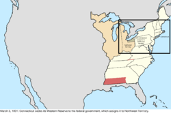 |
| April 26, 1802 | Georgia ceded its western half, known as the Yazoo Lands, to the federal government. At the same time, the federal government ceded to Georgia the eastern portion of the land previously ceded by South Carolina, though in reality Georgia technically already held title to the land, as the description of the earlier cession was based on an erroneous understanding of geography.[65] | 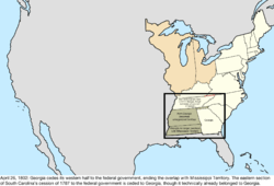 |
| March 1, 1803 | The southern half of Northwest Territory, along with a thin sliver of Indiana Territory, was admitted as the seventeenth state, Ohio. The remainder of Northwest Territory was transferred to Indiana Territory.[66][67] | 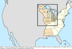 |
| November 3, 1803 | The border between Tennessee and Virginia was resurveyed and established, ending the dispute over that part of the border. The border between Kentucky and Tennessee, despite following the original survey, remained vaguely defined.[5][68] | 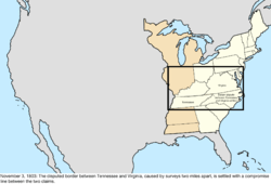 |
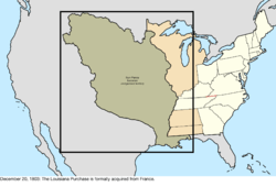
| December 20, 1803 | The United States purchased Louisiana from France. This is the date of the formal turnover in New Orleans; the purchase was completed on April 30, 1803.[69] The transfer would be recognized in St. Louis in Upper Louisiana on March 10, 1804, known as Three Flags Day.
The extent of what constituted Louisiana was disputed with Spain, with the United States claiming the territory included much of West Florida, as well as a dispute over the southwestern border with New Spain. |
 Disputes:
|
| 1804 | The "Southwick Jog" was transferred from Connecticut to Massachusetts, to put to rest long-standing disagreements over the border between the two states.[22] | 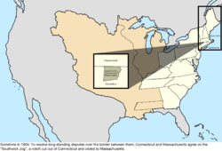 |
| March 27, 1804 | The land between Tennessee and Mississippi Territory previously ceded by Georgia was assigned to Mississippi Territory.[58][70] | 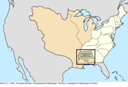 |
| October 1, 1804 | Orleans Territory was organized from the southern bit of the Louisiana Purchase, with the remainder being designated the District of Louisiana and placed under the jurisdiction of Indiana Territory.[71][72] | 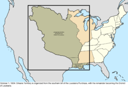 |
| June 30, 1805 | Michigan Territory was organized from the northeastern quarter of Indiana Territory.[73][74] The Michigan Territory disagreed with Ohio over the location of the border between them, beginning the dispute over the Toledo Strip, though at this point the dispute was technical rather than actual, since accurate mapping of the region was not yet available. | 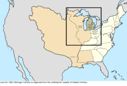 |
| July 4, 1805 | The District of Louisiana was organized as Louisiana Territory.[72][75] | 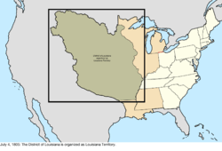 |
| March 1, 1809 | Illinois Territory was organized from the western bulk of Indiana Territory.[76][77] | 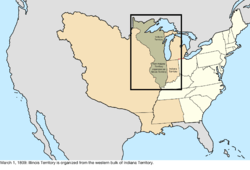 |
| September 26, 1810 | The Republic of West Florida declared independence from Spain. It maintained some control over its territory.[78] | Disputes: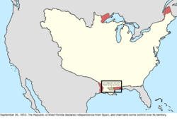 |
| December 10, 1810 | Armed forces led by William C. C. Claiborne took possession of the portion of West Florida west of the Pearl River, following a proclamation on October 27, 1810, by President James Madison to do so. The United States had considered the region part of the Louisiana Purchase, including the area which had revolted against Spanish Florida and formed the Republic of West Florida. Madison's proclamation stated that it was to be "taken as part" of Orleans Territory.[69][79][80] The land west of Mobile Bay to the Pearl River was occupied and annexed de facto by the military in 1811.[81]:2a(map) | Disputes: |
| April 30, 1812 | Most of Orleans Territory was admitted as the eighteenth state, Louisiana.[72][82] The remainder presumably became unorganized territory, as it had no definition for a while. | 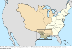 |
| May 14, 1812 | The claimed portion of West Florida east of the Pearl River was assigned to Mississippi Territory, though at the time, the area around Mobile Bay remained under the control of Spanish Florida.[58][83] The United States militarily occupied Mobile and the surrounding area up to the Perdido River in April 1813. | 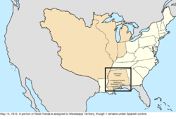 |
| June 4, 1812 | Louisiana Territory was renamed Missouri Territory.[84][85] | 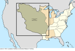 |
| August 4, 1812 | The remaining claimed portion of West Florida was added to Louisiana, following the assent of that state to an act passed by Congress on April 14, 1812.[86][87] | 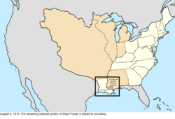 |
| August 16, 1812 | The garrison at Fort Detroit surrenders, leading the United Kingdom to occupy Michigan Territory.[88] | Disputes: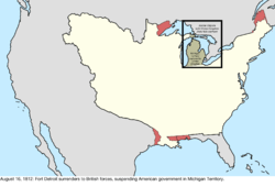 |
| September 29, 1813 | Fort Detroit was recaptured by American forces, regaining control over Michigan Territory.[88][89] | Disputes: |
| August 24, 1814 | British forces capture and burn Washington, but are forced to withdraw the next day. The functions of the capital were only momentarily suspended, though President James Madison took refuge in Brookville, Maryland.[90] | no change to map |
| December 11, 1816 | The southern part of Indiana Territory, along with small parts of Illinois Territory and Michigan Territory, were admitted as the nineteenth state, Indiana. A very small portion of Indiana Territory was transferred to Illinois Territory, and the northern part of Indiana Territory, across Lake Michigan, became unorganized territory.[60][91] | 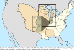 |
| March 3, 1817 | Alabama Territory was organized from the eastern half of Mississippi Territory.[92][93] | 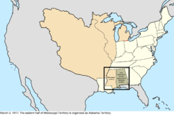 |
| December 10, 1817 | Mississippi Territory was admitted as the twentieth state, Mississippi.[58][94] | 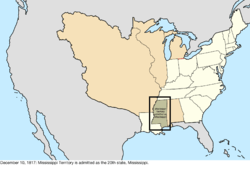 |
| February 6, 1818 | Alabama Territory created Tuskaloosa County with a description that inadvertently overlapped with Mississippi. It described the border of the county as running "a due west course to, the Tombeckbe river; thence up the same to the Cotton Gin Port."[95] Unknown at the time, the origin of the Tombigbee River and Cotton Gin Port were in Mississippi. | Change on paper only: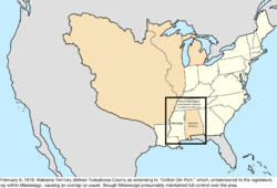 |
| June 30, 1818 | Per the terms of the Treaty of Ghent, the United Kingdom returned Moose Island to Massachusetts, and the United States returned Campobello Island, Deer Island, and Grand Manan Island to the United Kingdom, all of which were captured from the other side during the War of 1812.[96] | no change to map |
| December 3, 1818 | The southern half of Illinois Territory was admitted as the twenty-first state, Illinois. The remainder of the territory, along with the unorganized territory that was recently part of Indiana Territory, were assigned to Michigan Territory.[77][97] | 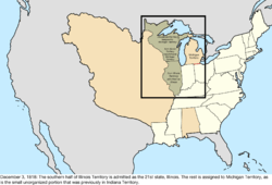 |
| January 30, 1819 | The Treaty of 1818 went into effect, setting the 49th parallel north as the border with the United Kingdom west of the Lake of the Woods, and also establishing the Oregon Country as a shared region with the United Kingdom.[98][99][100] Oregon Country had no defined northern limit, but it can be assumed that it did not encroach much upon Russian-held lands; this map uses the later-established line at parallel 54°40′ north for simplicity. | 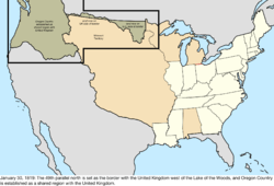 Northwestern North America: 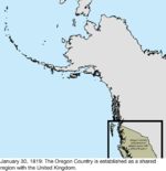 |
| July 4, 1819 | Arkansaw Territory was organized from the southern slice of Missouri Territory.[101][102] | 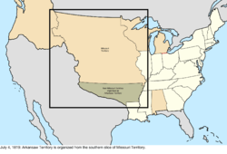 |
| December 14, 1819 | Alabama Territory was admitted as the twenty-second state, Alabama.[93][103] The statehood act provided for a survey of the southern part of the border with Mississippi for correction if it was discovered to encroach upon Mississippi; it was later discovered to do so. | 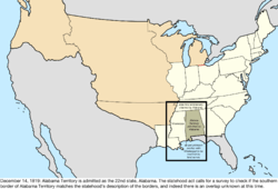 |
| March 15, 1820 | As part of the Missouri Compromise, the District of Maine, the northern and separate part of Massachusetts, was admitted as the twenty-third state, Maine.[104][105] | 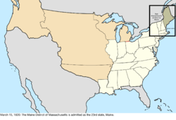 |
| April 21, 1820 | This is the first known date of the name "Arkansas Territory" being officially used instead of "Arkansaw Territory".[106] | 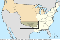 |
| May 12, 1820 | The border between Kentucky and Tennessee was established. To make up for the fact that the border between the Cumberland Gap and the Tennessee River veered north as much as 17 miles from 36°30′ north, a new survey was conducted starting at that point on the Mississippi River and moving east to the Tennessee River, hence granting Kentucky an addition in its southwest.[5] | 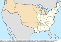 |
| July 19, 1820 | The overlap of the longitudinal southern border between Alabama and Mississippi was resolved, as per the act admitting Alabama as a state, because the provisional border encroached on Mississippi.[107][108] As the result of a survey, the southern border terminus was moved about 3.8 miles to the east, which changed the border up to the then-northwest corner of Alabama's Washington County. The date when this happened is unclear; the sources available give either an unpublished report dated May 29, 1820, or the completion of the demarcation of the new line on July 19, 1820. | Change on paper only: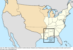 |
| December 19, 1820 | Alabama redefined some county borders, ending its erroneous overlap of Mississippi.[109] | Change on paper only: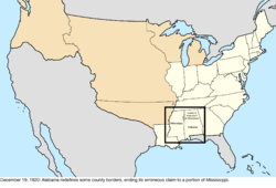 |
| February 22, 1821 | The Adams–Onís Treaty took effect.[80] The many changes included:
|
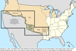 Disputes:  |
| July 10, 1821 | East Florida was formally transferred to the United States by Spain.[110] | 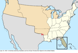 |
| July 17, 1821 | West Florida was formally transferred to the United States by Spain. Although Spain officially transferred the full extent of its province east of the Mississippi River, actual control of territory changed hands in the rump province that Spain still held.[110][111] | 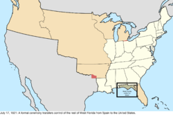 |
| August 10, 1821 | The southeastern corner of Missouri Territory was admitted as the twenty-fourth state, Missouri, the rest becoming unorganized territory.[85][112] | 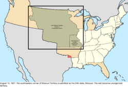 |
| September 28, 1821 | Mexico declared its independence from Spain, thus inheriting the dispute over Miller County, Arkansas Territory.[113] | Disputes: |
| March 30, 1822 | East Florida and West Florida were organized as Florida Territory.[114][115] | 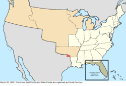 |
| May 26, 1824 | The western half of Arkansas Territory was returned to unorganized territory.[102][116] | 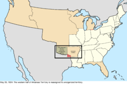 |
| January 12, 1825 | A treaty with the Russian Empire established the parallel 54°40′ north as the northern border of Oregon Country for American purposes; a separate treaty created the same border between Russia and the United Kingdom.[117] As this was likely the de facto border anyway, the region is already mapped with this line. | no change to map |
| May 6, 1828 | A treaty with the Cherokee moved the western border of Arkansas Territory, returning part of it to unorganized territory.[102][118] | 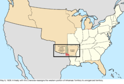 |
| July 9, 1832 | The northernmost region of New Hampshire, which was disputed with the United Kingdom, declared independence as the Republic of Indian Stream.[119] While tiny, it does appear to have maintained some control over its territory. | Disputes: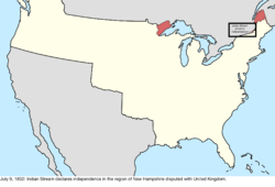 |
| June 28, 1834 | Michigan Territory gained a large parcel of land on its west from unorganized territory.[74][120] | 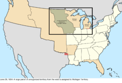 |
| August 5, 1835 | The Republic of Indian Stream recognized the jurisdiction of New Hampshire, thus ending its claimed independence. The date given is of a communication sent to British authorities;[121] other sources note a resolution passed by the citizens of Indian Stream on April 2, 1836.[119] | Disputes: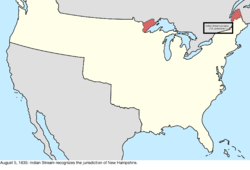 |
| March 2, 1836 | The Republic of Texas declared independence from Mexico, thus joining the dispute with Arkansas Territory over Miller County.[122] | Disputes: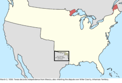 |
| June 15, 1836 | Arkansas Territory was admitted as the twenty-fifth state, Arkansas.[102][123] | 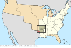 |
| July 3, 1836 | Wisconsin Territory was organized from the western bulk of Michigan Territory.[124][125] |  |
| December 14, 1836 | Michigan Territory agreed to abandon its claim to the Toledo Strip, ending its dispute with Ohio.[126] | 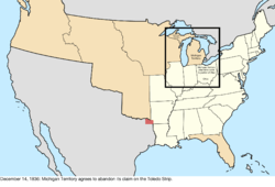 |
| December 28, 1836 | Spain recognized the independence of Mexico, thus ending its involvement in the dispute over Miller County, Arkansas.[127] | Disputes: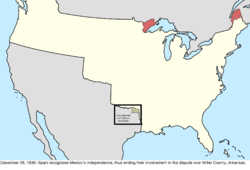 |
| January 26, 1837 | Michigan Territory was admitted as the twenty-sixth state, Michigan.[74][128] | 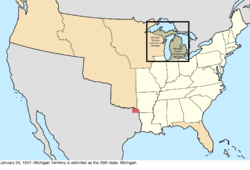 |
| March 28, 1837 | The Platte Purchase transferred some land from unorganized territory to northwest Missouri.[85][129] | 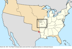 |
| July 3, 1838 | Iowa Territory was organized from the western half of Wisconsin Territory.[130][131] | 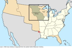 |
| February 11, 1839 | Missouri claimed an area north of its border in Iowa Territory, initiating the long dispute known as the Honey War.[132] | 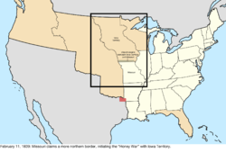 |
| May 21, 1840 | Proper surveying was conducted along the border between Arkansas and Texas, and the area claimed by Arkansas for Miller County was held not to belong to Arkansas.[133] With this decision, Miller County was no longer disputed with Mexico and Texas. | 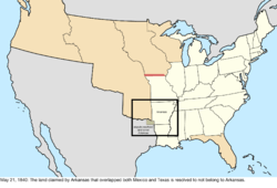 Disputes: 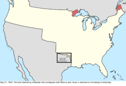 |
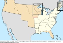
| November 10, 1842 | The Webster-Ashburton Treaty defined the border with the United Kingdom east of the Rocky Mountains.[134][135] One source also mentions it very slightly altering the maritime boundary between Michigan and Wisconsin Territory, but it lacks details on the exact change.[136] The treaty resolved the disputes over the northern borders of Maine, Michigan, New Hampshire, and Wisconsin Territory.
The border between New York and Vermont on the one side, and the United Kingdom on the other, was clarified by the treaty. In 1816, construction began on an unnamed fort nicknamed "Fort Blunder" on a peninsula in Lake Champlain that, while south of the surveyed border, was discovered to be north of the 45th parallel, which was the border set by the Treaty of Paris and thus in British territory. Consequently, construction on the fort was abandoned. The Webster-Ashburton Treaty specified that section of the border was to follow the surveyed line, rather than the exact parallel, thus moving the fort's area into the United States, and a new fort, Fort Montgomery, would be built on the spot in 1844.[137] As the earlier line was surveyed, even though it did not match the definition, it was deemed to be the legitimate border. |
 Disputes: 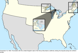 |
| July 5, 1843 | Local settlers created a provisional government for Oregon Country. While not official, it did maintain some jurisdiction over the area.[138] | Unofficial change: 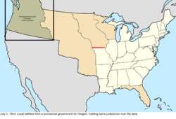 Northwestern North America: 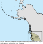 |
| March 3, 1845 | Florida Territory was admitted as the twenty-seventh state, Florida.[115][139] | 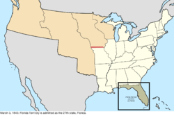 |
| December 29, 1845 | The Republic of Texas was annexed and admitted as the twenty-eighth state, Texas.[140][141] Texas brought with it a substantial territorial dispute with Mexico. While many sources state that Mexico recognized the independence of the eastern bulk of Texas, the treaties were rejected by the Mexican government. A substantial part of Texas remained under the control of Mexico (for example, see this map, which reflects the "boundary claimed by Mexico after 1836"), as Texas' claimed territory included portions of the Mexican states of Chihuahua, Coahuila and Tamaulipas and territories of Alta California and Santa Fe de Nuevo México. | 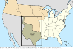 Disputes: 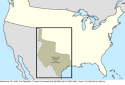 |
| June 15, 1846 | The Oregon Treaty established the 49th parallel north west of the Lake of the Woods as the continental border (so it did not include Vancouver Island) with land held by the United Kingdom. The sharing of Oregon Country ended, and the United States portion became unorganized territory.[142]
The treaty was vague on which strait should be the border between Vancouver Island and the continent, thus causing a dispute over ownership of the San Juan Islands.[143] It specified "through the middle of the said channel and of Fuca Straits, to the Pacific Ocean." The extension of the boundary beyond that point was proclaimed separately by Canada and the United States in 1977, each using a different method, with maritime borders overlapping in two disputed areas of water, 15 nm2 in total, which is still unresolved at present.[144] |
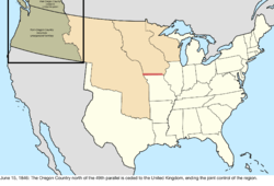 Northwestern North America: 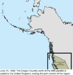 Disputes: 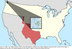 |
| August 18, 1846 | The United States Army of the West, led by Brigadier General Stephen W. Kearny, captured Santa Fe, the capital of Santa Fe de Nuevo México, Mexico, and proclaimed American sovereignty over the territory.[145] | no change to map |
| September 22, 1846 | A code of laws known as the Kearny Code was created for the area of Santa Fe de Nuevo México that had been captured on August 18, 1846.[146][147] The region overlapped with Texas' claim, though Texas had little to no control over the area outside of its eastern quarter. | Unofficial change: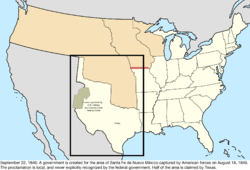 |
| December 28, 1846 | The southern portion of Iowa Territory was admitted as the twenty-ninth state, Iowa. The remainder became unorganized territory.[131][148] | 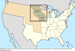 |
| March 13, 1847 | The District of Columbia retroceded Alexandria County back to Virginia.[47] Congress passed the act on July 9, 1846,[149] residents of Alexandria County were proclaimed by the president to have agreed to it on September 7, 1846,[150] and Virginia took possession of the land on this date.[151] | 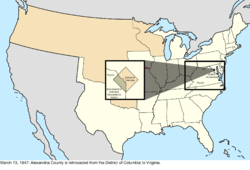 |
| May 29, 1848 | The southern bulk of Wisconsin Territory was admitted as the thirtieth state, Wisconsin. The remainder became unorganized territory.[125][152] However, the citizens of the remainder decided to continue on with a civil government, and even elected a delegate to the United States House of Representatives, whom would be seated on January 15, 1849, essentially making this region a de facto continuation of Wisconsin Territory.[153] | 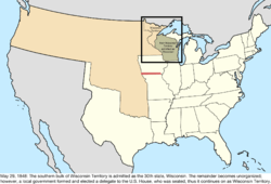 |
| July 4, 1848 | A large parcel of land was ceded by Mexico following the Mexican-American War, consisting of its territories of Alta California and Santa Fe de Nuevo México, and its claim to Texas.[154] Due to a disagreement over the southern border of Santa Fe de Nuevo México, a border dispute begins.[155] | 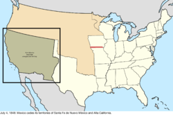 Disputes: 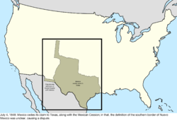 |
| August 14, 1848 | Oregon Territory was organized from unorganized territory.[156][157] | 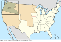 |
| February 13, 1849 | The boundary dispute between Iowa and Missouri known as the Honey War was resolved by the Supreme Court of the United States. The resulting border was the Sullivan Line that existed before the dispute, roughly splitting the two claims.[158] |  |
| March 3, 1849 | Minnesota Territory was organized from unorganized territory and the region that had been operating as de facto Wisconsin Territory.[159][160] | 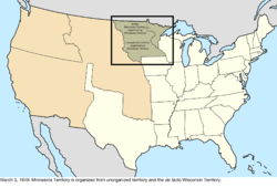 |
| March 12, 1849 | A local government in the west formed the State of Deseret and petitioned to be admitted to the United States. However, the proposal was rejected and, in 1850, Utah Territory was formed instead.[161] The claimed area overlapped slightly with Texas' claimed area, as well as part of Oregon Territory. | Unofficial change: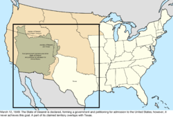 |
| September 9, 1850 | The western portion of the Mexican Cession was admitted as the thirty-first state, California.[162][163] The northern portion was organized as Utah Territory.[164][165] Part of Utah Territory overlapped with the portion of Texas that would be purchased on December 13, 1850, but the law authorizing such was passed on this day, so the borders of Utah Territory assumed the purchase will go through. | 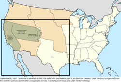 |
| December 9, 1850 | The United Kingdom ceded less than one acre of underwater rock known as Horseshoe Reef in Lake Erie near Buffalo, New York for a lighthouse. It was surrounded by Canadian waters, thus creating a form of enclave.[166] | 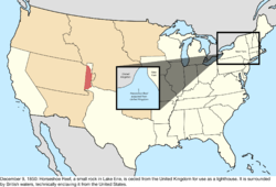 |
| December 13, 1850 | The federal government purchased the western claims of Texas. New Mexico Territory was organized from the southern half of this land, along with some other territory in the Mexican Cession.[167][168] New Mexico Territory included all of the area that had been governed under the Kearny Code. | 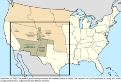 |
| April 5, 1851 | The State of Deseret dissolved itself, its functions and territory largely having been superseded by Utah Territory.[169] | no change to map |
| March 2, 1853 | Washington Territory was organized from the northern half of Oregon Territory.[170][171] | 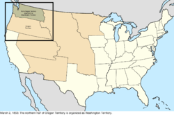 |
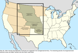
| May 30, 1854 | Kansas Territory and Nebraska Territory were organized from unorganized territory.[172][173][174] Much of the remaining unorganized territory became known as Indian Territory, designated as a place to resettle Indian tribes.
A small strip between Texas and Kansas Territory was unclaimed, due to falling south of Kansas Territory's border but north of the 36°30′ latitude established in the Missouri Compromise as the northern limit of slavery, and thus Texas could not have it. This became known as the Public Land Strip, or sometimes "No Man's Land."[175] |
 |
| June 30, 1854 | The United States purchased a large parcel from Mexico known as the Gadsden Purchase.[176] This resolved the border dispute, since the disputed land was included in the purchase.[155] | 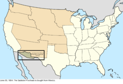 Disputes: 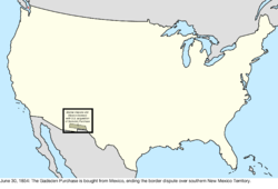 |
| August 4, 1854 | The recently obtained Gadsden Purchase was assigned to New Mexico Territory.[168][177] | 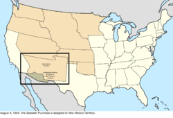 |
| January 11, 1855 | Due to its remote location, Boston Corner was transferred from Massachusetts to New York.[178][179][180] | 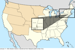 |
| October 28, 1856 | Baker Island and Jarvis Island were claimed under the Guano Islands Act.[181] | Pacific Ocean: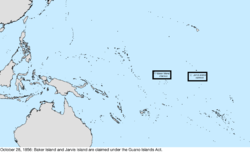 |
| May 11, 1858 | The eastern half of Minnesota Territory was admitted as the thirty-second state, Minnesota. The remainder became unorganized territory.[160][182] | 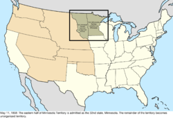 |
| August 31, 1858 | Navassa Island was claimed under the Guano Islands Act.[181] | Caribbean Sea: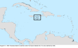 |
| December 3, 1858 | Howland Island was claimed under the Guano Islands Act.[181] | Pacific Ocean: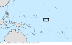 |
| February 14, 1859 | The western half of Oregon Territory was admitted as the thirty-third state, Oregon. The remainder was transferred to Washington Territory.[157][183] Later, location errors in an 1868–1870 survey to demarcate the Oregon-California border created a dispute with California, which upon statehood had established the 42nd parallel as its de jure border, based on the 1819 Adams–Onís Treaty between the United States and Spain. The dispute continues to the present.[184][185][186][187] | 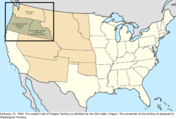 |
| July 6, 1859 | A team of surveyors created the "Middleton Offset," a small notch in the border between Kentucky and Tennessee. It is unknown exactly why this was done.[188][189] | 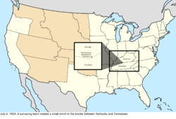 |
| September 6, 1859 | Johnston Atoll was claimed under the Guano Islands Act.[181] It was claimed by Kingdom of Hawaii in 1858.[190] | Pacific Ocean: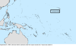 |
| November 7, 1859 | A local government was set up encompassing parts of the territories of Kansas, Nebraska, New Mexico, Utah, and Washington, with the name of Jefferson Territory. While never recognized by the federal government, it generally held control over the area until Colorado Territory was established, which adopted most of its laws.[191] | Unofficial change: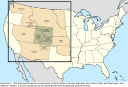 |
| December 27, 1859 | Enderbury Island, McKean Island, Phoenix Island, and Starbuck Island were claimed under the Guano Islands Act.[181] | Pacific Ocean: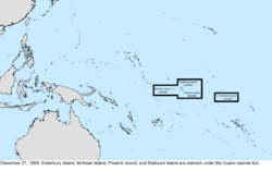 |
| December 29, 1859 | Christmas Island and Malden Island were claimed under the Guano Islands Act.[181] | Pacific Ocean: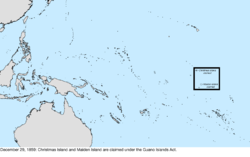 |
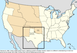
| February 8, 1860 | Texas created Greer County, claiming part of Indian Territory based on a different understanding from the federal government of which river was the border between the two.[192]
Atafu, Birnie Island, Butaritari, Caroline Island, Fanning Island, Flint Island, Gardner Island, Canton Island, Kingman Reef, Manihiki, Marakei, Nukunono, Palmyra Atoll, Penrhyn, Pukapuka, Rakahanga, Swains Island, Sydney Island, Vostok Island, and Washington Island were all claimed under the Guano Islands Act.[181] Many additional islands were listed as bonded on this date, but based on the coordinates they were either phantoms or duplicates. In addition, Sarah Ann Island was claimed, which may have existed and would be sighted as late as 1917, but has since disappeared.[193] |
 Pacific Ocean: 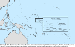 |
| December 20, 1860 | South Carolina proclaimed its secession from the Union, withdrawing from the Congress of the United States.[194] | 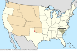 Disputes: 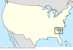 |
| January 9, 1861 | Mississippi proclaimed its secession from the Union, withdrawing from Congress.[194] | 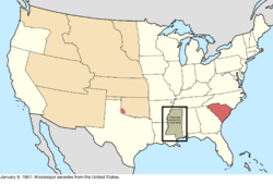 Disputes: 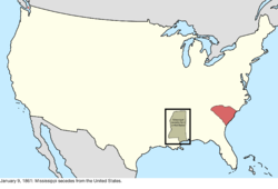 |
| January 10, 1861 | Florida proclaimed its secession from the Union, withdrawing from Congress.[194] | 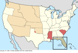 Disputes: 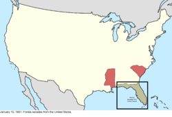 |
| January 11, 1861 | Alabama proclaimed its secession from the Union, withdrawing from Congress.[194] | 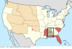 Disputes: 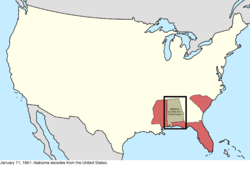 |
| January 19, 1861 | Georgia proclaimed its secession from the Union, withdrawing from Congress.[194] | 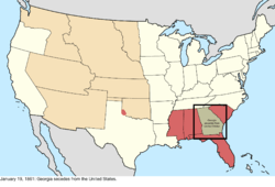 Disputes: 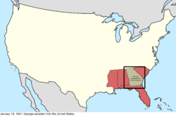 |
| January 26, 1861 | Louisiana proclaimed its secession from the Union, withdrawing from Congress.[194] However, Districts 1 and 2 around New Orleans remained under Union control and maintained representation in Congress. | 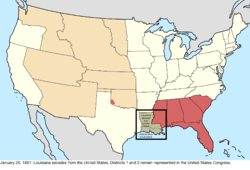 Disputes: 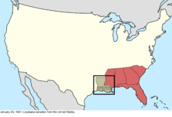 |
| January 29, 1861 | The eastern bulk of Kansas Territory was admitted as the thirty-fourth state, Kansas. The remainder became unorganized territory.[173][195] | 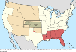 |
| February 8, 1861 | The Confederate States of America was formed by representatives of the states of Alabama, Georgia, Florida, Louisiana, Mississippi, and South Carolina.[196] | Disputes: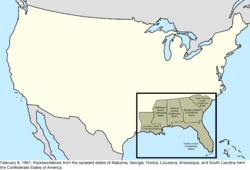 |
| February 28, 1861 | Colorado Territory was organized from portions of Nebraska Territory, New Mexico Territory, and Utah Territory, along with unorganized territory.[197][198] | 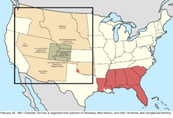 |
| March 2, 1861 | Texas proclaimed its secession from the Union and was admitted to the Confederate States,[194][199] withdrawing from Congress.
Dakota Territory was organized from the northern bulk of Nebraska Territory and unorganized territory, and Nebraska Territory gained small portions of Utah Territory and Washington Territory.[174][200][201] Nevada Territory was organized from the western part of Utah Territory.[202][203] |
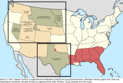 Disputes: 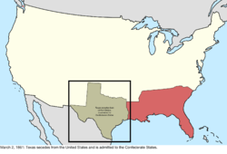 |
| March 28, 1861 | Representatives in southern New Mexico Territory proclaimed an independent Arizona Territory.[204] | Disputes: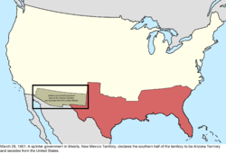 |
| April 17, 1861 | Virginia proclaimed its secession from the Union, withdrawing from Congress.[194] However, Districts 1 (along the Eastern Shore), 7 (near Washington, D.C.), and 10, 11, and 12 (in the northwest of the state) remained under Union control and maintained representation in Congress. | 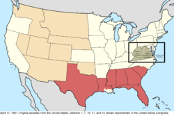 Disputes: 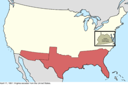 |
| May 6, 1861 | Arkansas proclaimed its secession from the Union, withdrawing from Congress.[194] | 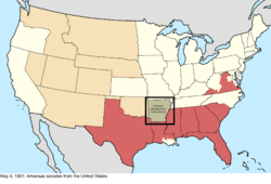 Disputes: 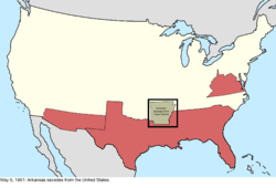 |
| May 7, 1861 | Virginia was admitted to the Confederate States.[205] | Disputes: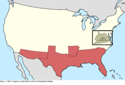 |
| May 20, 1861 | Arkansas was admitted to the Confederate States.[206]
North Carolina proclaimed its secession from the Union, withdrawing from Congress.[194] |
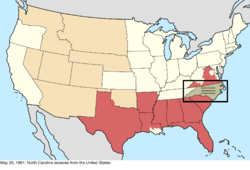 Disputes: 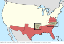 |
| June 6, 1861 | Robert Williamson Steele, governor of Jefferson Territory, declared the territory disbanded and handed over the government to the first governor of Colorado Territory.[191] | no change to map |
| June 8, 1861 | Tennessee proclaimed its secession from the Union, withdrawing from Congress.[194] However, Districts 2, 3, and 4 in the central part of the state remained under Union control and maintained representation in Congress. | 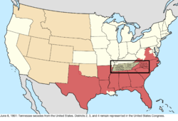 Disputes: 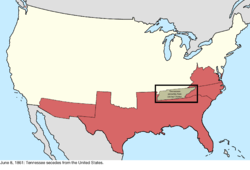 |
| July 2, 1861 | Tennessee was admitted to the Confederate States.[207] | Disputes: |
| July 12, 1861 | Some of the Five Civilized Tribes signed various treaties with the Confederate States; on this date the Treaty with the Choctaw and Chickasaw was signed,[208] which granted them delegation in the Confederate Congress.[209] Due to the complex and split nature of Indian Territory during the American Civil War, this is when the list marks the region as generally allied with the Confederate States. | Disputes: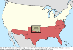 |
| July 20, 1861 | North Carolina was admitted to the Confederate States. The law admitting the state required a presidential proclamation before it was to take effect,[210] which occurred on this date.[211] | Disputes: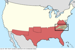 |
| August 1, 1861 | Following a Confederate victory in the First Battle of Mesilla, Arizona Territory was proclaimed as part of the Confederate States.[212] | Disputes: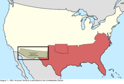 |
| October 31, 1861 | A splinter government in Neosho, Missouri, declared the secession of the state from the United States.[194] | Disputes: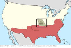 |
| November 20, 1861 | A convention in Russellville, Kentucky, declared the formation of a splinter government in Bowling Green and the secession of Kentucky from the United States.[194] | Disputes: |
| November 28, 1861 | The splinter Neosho government of Missouri was admitted to the Confederate States. The Confederate States never held much power over the state, but it was given full representation in the legislature.[213] | Disputes: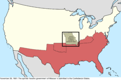 |
| December 10, 1861 | The splinter Bowling Green government of Kentucky was admitted to the Confederate States. The Confederate States never held much power over the state, but it was given full representation in the legislature.[214] | Disputes: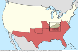 |
| March 1, 1862 | A decree by the Supreme Court of the United States took effect, modifying the border between Massachusetts and Rhode Island.[22][215] | 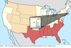 |
| April 15, 1862 | Palmyra Atoll was annexed by the Kingdom of Hawaii, and the American claim falls dormant.[216] | Pacific Ocean: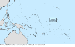 |
| July 14, 1862 | The western slice of Utah Territory was transferred to Nevada Territory, moving the border between the two east from the 39th meridian west of Washington to the 38th.[203][217] | 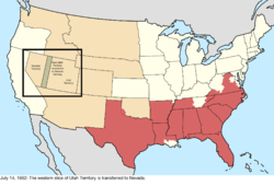 |
| December 30, 1862 | The Swan Islands were claimed under the Guano Islands Act.[181] | Caribbean Sea: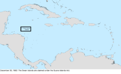 |
| February 24, 1863 | Arizona Territory was organized from the western half of New Mexico Territory.[107][218] | 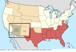 |
| March 3, 1863 | Idaho Territory was organized from the western portions of Dakota Territory and Nebraska Territory, and the eastern portion of Washington Territory.[219][220] | 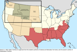 |
| March 4, 1863 | Due to disruption in voting and low turnout, no one was allowed to take the seats held in the United States House of Representatives by the Unionist areas of Louisiana, Tennessee, and Virginia, effectively expelling the states. | 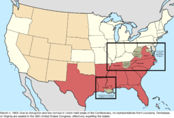 |
| June 20, 1863 | The northwestern counties of Virginia, represented by the Restored Government of Virginia in Wheeling, seceded from Virginia and were admitted to the Union as the thirty-fifth state, West Virginia.[221][222] | 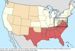 |
| August 5, 1863 | Berkeley County was transferred by the federal government from Virginia to West Virginia;[223] Virginia, being a member of the Confederate States at the time, had no input into the matter. | 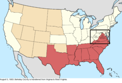 |
| November 2, 1863 | Jefferson County was transferred from Virginia to West Virginia.[224] Virginia, being a member of the Confederate States at the time, had no input into the matter. | 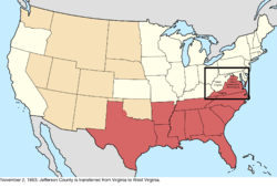 |
| May 26, 1864 | Montana Territory was organized from the northeast third of Idaho Territory.[225] The southeast third of Idaho Territory was transferred to Dakota Territory.[226] | 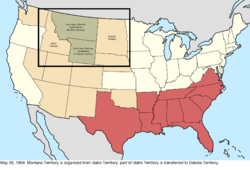 |
| October 15, 1864 | Malden Island was claimed by the United Kingdom.[227] | Pacific Ocean: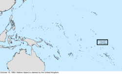 |
| October 31, 1864 | Nevada Territory was admitted as the thirty-sixth state, Nevada.[203][228] | 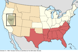 |
| May 5, 1865 | The Confederate States cabinet met in Washington, Georgia, and dissolved.[229] Military surrenders were scattered throughout 1865, but the most important is regarded as that of the Army of Northern Virginia following the Battle of Appomattox Court House on April 9. | Disputes: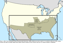 |
| May 5, 1866 | The western slice of Utah Territory was transferred to Nevada, moving the border between the two east from the 38th meridian west of Washington to the 37th.[230] | 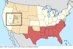 |
| July 24, 1866 | Tennessee was readmitted to Congress.[231] | 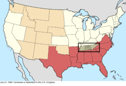 |
| December 26, 1866 | Starbuck Island was claimed by the United Kingdom.[227] | Pacific Ocean: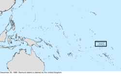 |
| January 18, 1867 | The northwestern corner of Arizona Territory was transferred to Nevada. The law transferring the land was approved May 5, 1866, but unlike the Utah Territory transfer of that day, this transfer was contingent on the state accepting it.[230][232] | 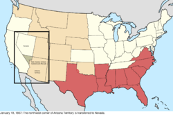 |
| March 1, 1867 | Nebraska Territory was admitted as the thirty-seventh state, Nebraska.[174][233] | 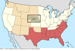 |
| July 1, 1867 | Canada was formed from several British colonies, including New Brunswick, thus inheriting the dispute over Machias Seal Island and North Rock. | Disputes: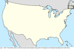 |
| August 28, 1867 | Midway Atoll was claimed.[234] The largest island of Midway, Sand Island, had been claimed under the Guano Islands Act in 1858, but nothing more is known about this.[235] | Pacific Ocean: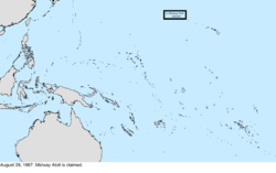 |
| October 18, 1867 | Alaska was purchased from the Russian Empire and designated the Department of Alaska.[236] Due to a lack of quality surveying, the southeastern border with British holdings was unclear and disputed.[237] As well, the purchase treaty quoted the Anglo-Russian Convention of 1825 for the demarcation northward from there along the 141° west meridian. In 1977 the United States revealed its position that the 141st meridian does not extend seaward as the maritime border in the Beaufort Sea, disputing Canada's jurisdiction of 6250 nm2. Resolution continues to hinge on the meaning of one word, jusqu'à, in the 1825 treaty's authentic French text.[144] | Northwestern North America: |
| June 22, 1868 | Arkansas was readmitted to Congress.[238] | 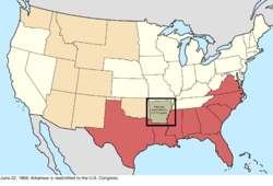 |
| June 25, 1868 | Florida was readmitted to Congress.[239] | 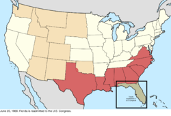 |
| July 4, 1868 | North Carolina was readmitted to Congress.[240] | 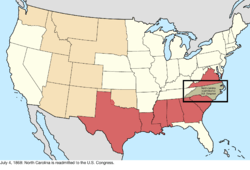 |
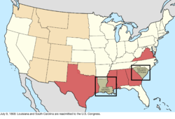
| July 9, 1868 | Louisiana and South Carolina were readmitted to Congress.[241]
Caroline Island was claimed by the United Kingdom.[227] |
 Pacific Ocean: 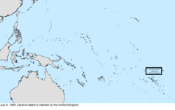 |
| July 13, 1868 | Alabama was readmitted to Congress.[242] | 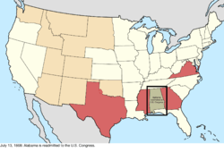 |
| July 25, 1868 | Georgia was readmitted to Congress.[243]
Wyoming Territory was organized from portions of Dakota, Idaho, and Utah Territories.[244][245] The territory would remain under the jurisdiction of the Dakota Territory until its own government was organized on May 19, 1869.[246] The act organizing Wyoming Territory became law on this date, but it is unclear if the territory could be considered "organized" until May 19, 1869, as the act specifies it was not to take effect until a government is organized; however, all sources use this date as the creation, and most use it for the organization, of the territory. A tiny portion of the Dakota Territory was erroneously left behind on the western side of Wyoming Territory.[247] |
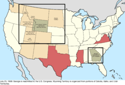 |
| August 12, 1868 | The list of bonded guano island claims mentions "Islands in Caribbean Sea not named" bonded on this date, but it is unknown what this is referring to.[181] | no change to map |
| December 11, 1868 | Serrana Bank was claimed under the Guano Islands Act.[181] Colombia has claimed it throughout its history. | Caribbean Sea: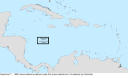 |
| March 3, 1869 | Georgia was again expelled from Congress following failures of Reconstruction in the state.[248] | 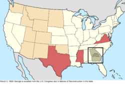 |
| November 22, 1869 | Bajo Nuevo Bank, Pedro Cays, Quita Sueño Bank, and Roncador Bank were claimed under the Guano Islands Act.[181][234] Except for Pedro Cays, Colombia has claimed them throughout its history. | Caribbean Sea: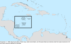 |
| January 26, 1870 | Virginia was readmitted to Congress.[249] | 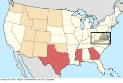 |
| February 23, 1870 | Mississippi was readmitted to Congress.[250] | 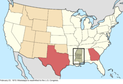 |
| March 30, 1870 | Texas was readmitted to Congress.[251] | 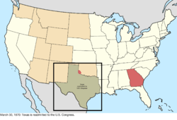 |
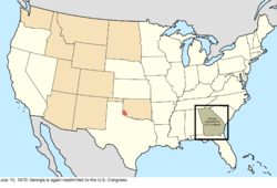
| July 15, 1870 | Georgia was again readmitted to Congress.[252]
The North-Western Territory was transferred by the United Kingdom to Canada, thus transferring its portion of the Alaska boundary dispute.[253] |
 Northwestern North America: 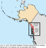 |
| February 9, 1871 | A small parcel was transferred from Dakota Territory to Nebraska following a sudden change in course of the Missouri River.[174][254] | 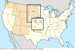 |
| July 20, 1871 | British Columbia joined Canada, transferring the dispute over the San Juan Islands as well as its portion of the Alaska boundary dispute.[255] | Disputes: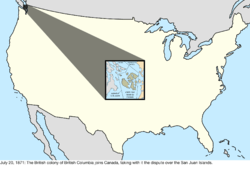 Northwestern North America: 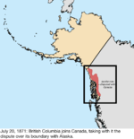 |
| October 21, 1872 | The dispute with Canada over the San Juan Islands was resolved in the favor of the United States claim.[143] | Disputes: |
| 1873 | Vostok Island was claimed by the United Kingdom.[256] | Pacific Ocean: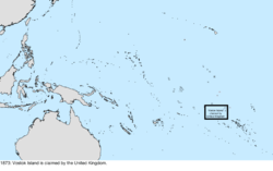 |
| February 17, 1873 | The small portion of Dakota Territory that was left behind due to an erroneous description of the borders of the territory was transferred to Montana Territory.[247][257] | 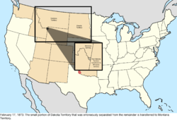 |
| August 1, 1876 | Colorado Territory was admitted as the thirty-eighth state, Colorado.[198][258] | 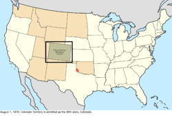 |
| August 13, 1877 | The United Kingdom created the British Western Pacific Territories, including all islands thought previously unclaimed. It included Atafu and Nukunono Atolls.[259] | Pacific Ocean: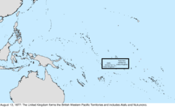 |
| March 3, 1879 | The border across the Chesapeake Bay between Maryland and Virginia was decided via arbitration. The new border cuts across Smith Island, likely meaning that the southern portion of the island was transferred to Virginia, but due to the general lack of concrete borders in the area for so long due to surveying errors, it is unknown if any land actually changed hands.[260] | too vague to map |
| September 8, 1879 | Arenas Key, claimed by Mexico, and Serranilla Bank, claimed by Colombia, were claimed by the United States under the Guano Islands Act;[181] according to the Office of Insular Affairs, Serranilla Bank was claimed again on September 13, 1880.[234] | Caribbean Sea: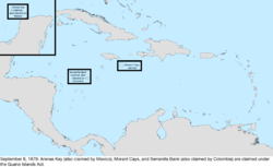 |
| April 7, 1880 | A very small area of Vermont near Fair Haven was transferred to New York due to a change in the course in the Poultney River.[8][261] The specific area was very small and poorly documented, so it is not mapped. | too small to map |
| September 13, 1880 | Western Triangle Island, claimed by Mexico, was claimed by the United States under the Guano Islands Act.[181] The list of bonded claims also mentions a "De Anes" island claimed on this date, with coordinates matching Isla de Aves; however, the same list points out that the claim to "Aves Island" was found to be invalid. | Caribbean Sea: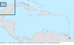 |
| 1881 | Flint Island was claimed by the United Kingdom.[262] | Pacific Ocean: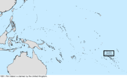 |
| May 23, 1882 | The area between the 43rd parallel north and the Keya Paha and Niobrara Rivers was transferred from Dakota Territory to Nebraska.[201][263] The act was passed in Congress on March 28 and accepted by the Nebraska legislature on May 23.[264] | 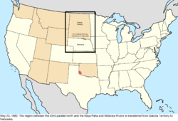 |
| June 1, 1882 | The Morant Cays and Pedro Cays were annexed by the United Kingdom to Jamaica; it appears they were no longer claimed by the United States after this.[265] | Caribbean Sea: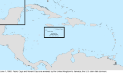 |
| May 17, 1884 | The Department of Alaska was organized into the District of Alaska.[266] | Northwestern North America: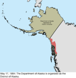 |
| June 21, 1884 | The Alacrans Islands, claimed by Mexico, were claimed under the Guano Islands Act.[181] | Caribbean Sea: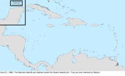 |
| March 15, 1888 | Fanning Island was annexed by the United Kingdom; it appears the island was no longer claimed by the United States after this.[267] | Pacific Ocean: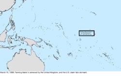 |
| March 17, 1888 | Christmas Island was claimed by the United Kingdom.[227] | Pacific Ocean: |
| October 26, 1888 | The Cook Islands became a protectorate of the United Kingdom, thus initiating a claim on the atolls of Pukapuka, Manihiki, Penrhyn, and Rakahanga.[227] | Pacific Ocean: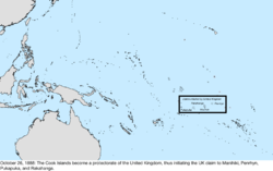 |
| May 29, 1889 | Washington Island was annexed by the United Kingdom; it appears the island was no longer claimed by the United States after this.[267] | Pacific Ocean: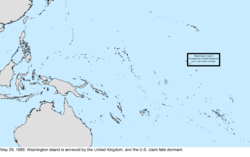 |
| June 3, 1889 | Jarvis Island was claimed by the United Kingdom.[227] | Pacific Ocean: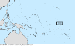 |
| June 26, 1889 | Sydney Island was claimed by the United Kingdom.[227] | Pacific Ocean: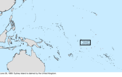 |
| June 29, 1889 | Phoenix Island was claimed by the United Kingdom.[227] | Pacific Ocean: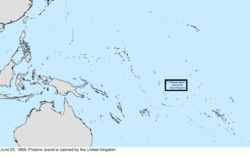 |
| July 10, 1889 | Birnie Island was claimed by the United Kingdom.[227] | Pacific Ocean: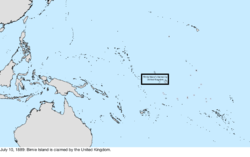 |
| November 2, 1889 | Dakota Territory was split and admitted as the thirty-ninth state, North Dakota, and the fortieth state, South Dakota.[201][268] | 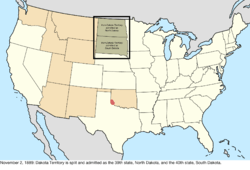 |
| November 8, 1889 | Montana Territory was admitted as the forty-first state, Montana.[225][268] | 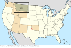 |
| November 11, 1889 | Washington Territory was admitted as the forty-second state, Washington.[171][268] | 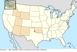 |
| May 2, 1890 | Oklahoma Territory was organized from the Public Land Strip and the western half of Indian Territory, except for the Cherokee Outlet, which would be added later upon cession from the Cherokee.[269][270] | 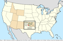 |
| July 3, 1890 | Idaho Territory was admitted as the forty-third state, Idaho.[220][271] | 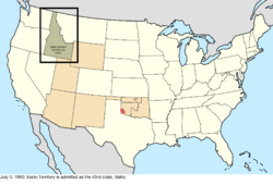 |
| July 10, 1890 | Wyoming Territory was admitted as the forty-fourth state, Wyoming.[245][272] | 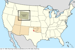 |
| March 8, 1892 | The Gilbert Islands became a protectorate of the United Kingdom, thus initiating a claim on Butaritari and Marakei.[227] No record of a United States claim exists after this point, so it is assumed this is when the claim fell dormant. | Pacific Ocean: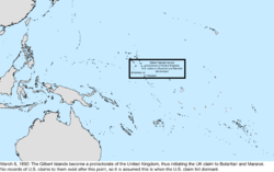 |
| May 28, 1892 | Gardner Island was claimed by the United Kingdom.[227] | Pacific Ocean: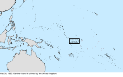 |
| September 16, 1893 | Per a treaty with the Cherokee, the federal government purchased the Cherokee Outlet and opened it to settlement, transferring it from Indian Territory to Oklahoma Territory as provided in the Oklahoma Organic Act.[270][273] | 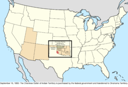 |
| November 17, 1894 | The Alacrans Islands, Arenas Key, and Western Triangle Island were stricken from the list of claimed guano islands.[181] | Caribbean Sea: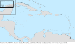 |
| January 4, 1896 | Utah Territory was admitted as the forty-fifth state, Utah.[165][274] | 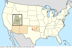 |
| March 16, 1896 | The dispute between the federal government, on behalf of Oklahoma Territory, and Texas over Greer County was resolved in favor of the federal claim.[192] | 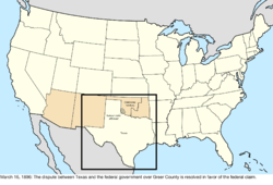 |
| July 24, 1897 | Due to an earlier shift in the course of the Missouri River, an island was transferred from Nebraska to South Dakota.[275] | 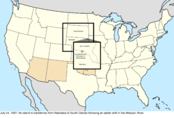 |
| August 12, 1898 | The Republic of Hawaii was annexed.[276] The ceremony to transfer sovereignty occurred on this date; the act was signed on July 7, 1898.[277] Johnston Atoll was not included with Hawaii, nor was Sikaiana Atoll, which had been ceded to Hawai‘i in 1856 by its residents and approved by King Kamehameha IV. However, the annexation was based on the islands named in a report of the Hawaiian Commission, which omitted Sikaiana.[278][279] | Pacific Ocean: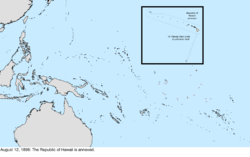 |
| January 17, 1899 | Wake Island was claimed.[280] | Pacific Ocean: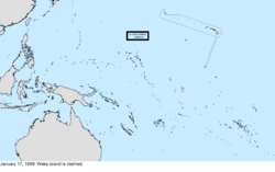 |
| April 11, 1899 | Guam, Porto Rico, and, after a payment of $20 million, the Philippines were ceded by Spain following the Spanish–American War.[281] The ceded region for the Philippines included the island of Palmas, which was administered by the Netherlands in the Dutch East Indies. This overlap would not be noticed until January 21, 1906.[282] | Pacific Ocean: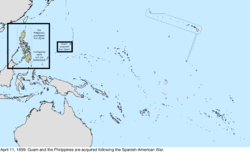 Caribbean Sea: 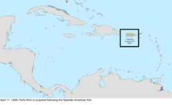 |
| February 16, 1900 | The United States took ownership of the Samoan Islands east of the 171st meridian west, per the terms of the Tripartite Convention.[283] | Pacific Ocean: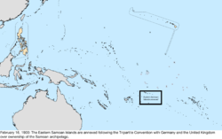 |
| February 19, 1900 | The newly acquired Samoan islands were established as Naval Station, Tutuila. It included all of the islands granted by the Tripartite Convention, though formal cession of the islands by local authorities would take place later in 1900 and 1904.[283] | Pacific Ocean: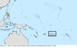 |
| April 10, 1900 | The island of Tutuila was formally ceded to the United States and added to Naval Station, Tutuila.[283] As the United States had already claimed the island on February 19, 1900, no change is mapped. The treaty would be ratified by Congress on February 20, 1929. | no change to map |
| April 12, 1900 | Porto Rico was organized into a civil territory.[284] | no change to map |
| June 14, 1900 | The former Republic of Hawaii was organized into Hawaii Territory.[285] | Pacific Ocean: |
| March 3, 1901 | The transfer for a thin sliver of Bristol, Tennessee, to Bristol, Virginia, was approved by Congress after having been approved by both states.[286][287] The location of the border along Main Street (now State Street) between the two cities was either the northern sidewalk of the street, or down the middle of the street; Tennessee's cession of the northern half of the street laid the issue to rest. | too small to map |
| March 23, 1901 | The islands of Cagayan de Sulu and Sibutu, and their associated islands, were purchased from Spain and assigned to the Philippines. The borders specified in the Treaty of Paris of 1898 had excluded these islands; the new treaty simply ceded "any and all islands belonging to the Philippine Archipelago".[288][289] | Pacific Ocean: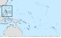 |
| February 23, 1903 | Land along southern Guantánamo Bay was leased in perpetuity from Cuba for use as a naval base.[290] | no change to map |
| October 20, 1903 | The Alaska boundary dispute with Canada was resolved, generally in favor of the United States claim.[237] However, it created a new dispute regarding the status of Dixon Entrance, and in 1977 the United States claimed 828 nm2 of sea that overlapped Canada's claim. The matter remains in dispute up to the present.[144] | Northwestern North America: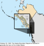 |
| May 4, 1904 | The United States took ownership of the Panama Canal Zone. At this stage, only the most basic borders were defined; it was a zone surrounding the canal on each side for five miles, but excluded the cities of Colón and Panama City, which remained exclaves of Panama, as well as the water for their harbors.[291] The Hay–Bunau-Varilla Treaty granting it to the United States was ratified on February 26, 1904.[292] A formal border agreement, which also gave the Canal Zone some land and a lighthouse in northwest Colón, would be ratified on June 15, 1904.[293][294] | Caribbean Sea: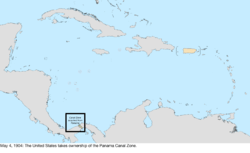 |
| July 16, 1904 | The Manuʻa islands were formally ceded to the United States and added to Naval Station, Tutuila.[283] As the United States had already claimed the islands on February 19, 1900, no change is mapped. The treaty would be ratified by Congress on February 20, 1929. | no change to map |
| December 12, 1904 | The "Taft Agreement" was made with Panama on December 3, with one of its sections refining the maritime boundary of the harbor of Panama City and the Panama Canal Zone.[295][296] It became effective December 12. | no change to map |
| February 10, 1905 | The border between Arkansas and Indian Territory was slightly adjusted near Fort Smith, Arkansas, transferring a small amount of land to Arkansas.[297][298] | 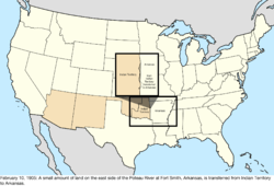 |
| November 16, 1907 | Indian Territory and Oklahoma Territory were combined and admitted as the forty-sixth state, Oklahoma.[270][299] | 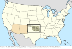 |
| April 11, 1908 | A boundary treaty with the United Kingdom on behalf of Canada redefined the maritime borders between the United States and Canada.[300] Among other changes, this "de-enclaved" Horseshoe Reef in Lake Erie by making the water around it contiguous with the water on the American side of the border.[166][301] | no change to map |
| January 1, 1909 | The new Constitution of Michigan included some area of Wisconsin within its definition of Michigan.[302] | 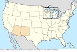 |
| August 20, 1910 | A boundary treaty with the United Kingdom on behalf of Canada addressed a slight uncertainty in the maritime border in Passamaquoddy Bay between Maine and Canada.[303][304] The border was adjusted to run east of Pope's Folly Island, which previously lay on the border line, and had been the subject of some debate for many years.[305][306] | 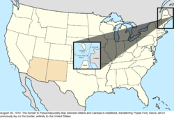 |
| July 17, 1911 | Naval Station, Tutuila, was renamed American Samoa;[307] the station continued to operate separate from territorial governance until 1951. | Pacific Ocean: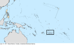 |
| January 6, 1912 | New Mexico Territory was admitted as the forty-seventh state, New Mexico.[168][308] |  |
| February 14, 1912 | Arizona Territory was admitted as the forty-eighth state, Arizona.[107][309] | 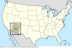 |
| August 24, 1912 | The District of Alaska was reorganized as the Alaska Territory.[310] | Northwestern North America: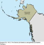 |
| January 31, 1913 | New Mexico filed suit in the Supreme Court against Texas over the "Country Club Dispute".[311] | 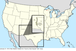 |
| August 5, 1914 | The Corn Islands were leased from Nicaragua for a period of 99 years; however, this was not a full transfer of sovereignty, and the islands were never administered as an insular area.[312] | no change to map |
| May 1, 1915 | The borders of the Panama Canal Zone were explicitly defined. Whereas the original definition was a simple corridor surrounding the canal, this treaty specified the actual border. Among the changes this caused were: a slice of Canal Zone was ceded to Panama so Panama City would be connected with the rest of the country; the middle island of the Las Tres Hermanas Islands, which marked the border of Panama City's harbor, was wholly made part of Canal Zone; Gatun Lake and other surrounding waters were formally annexed to the territory; and an area of northwest Colón was ceded to Canal Zone.[313][314][315] | Caribbean Sea: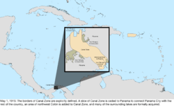 |
| May 27, 1915 | Under Article II of the 1903 Treaty, the United States expropriated from Panama several areas around the mouth of the Rio Chagres, annexing them to the Panama Canal Zone.[316] | too small to map |
| December 8, 1915 | The United States expropriated from Panama a triangle of land, which included the historic Fort San Lorenzo, between the Rio Chagres, Caribbean Sea and the Panama Canal Zone, to which it was annexed.[316] | too small to map |
| January 17, 1916 | Navassa Island was formally claimed for lighthouse purposes.[317] | no change to map |
| March 31, 1917 | The Danish Virgin Islands were purchased from Denmark[318] and renamed the United States Virgin Islands.[319] | Caribbean Sea: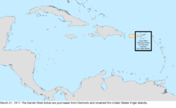 |
| July 12, 1918 | The United States expropriated from Panama 2.6 hectares of land at Punta Paitilla in Panama City and annexed it to the Panama Canal Zone.[320] That area was enlarged to about 50 hectares within several months.[316][321][322][323] | too small to map |
| August 21, 1918 | The United States expropriated from Panama land between the Rio Chagres and the Quebrada Majagual and annexed it to the Panama Canal Zone.[316][323] | Caribbean Sea: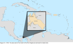 |
| September 13, 1918 | Minnesota and Wisconsin exchanged islands in the Mississippi River: Island Seventytwo was transferred from Wisconsin to the Minnesota town of Winona, and Barron's Island was transferred from Minnesota to the Wisconsin town of La Crosse.[125][324] | 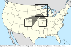 |
| September 18, 1919 | The island of Largo Remo was annexed to the Panama Canal Zone under the United States right of expropriation in the 1903 Canal Treaty.[325] | Caribbean Sea: |
| June 16, 1920 | Fifteen hectares on the island of Taboga Island were annexed to the Panama Canal Zone.[326] | too small to map |
| June 30, 1921 | The "Wedge" dispute between Delaware and Pennsylvania was resolved in Delaware's favor. The disputed land had generally been administered by Delaware, even electing a member of the Delaware legislature in the mid-19th century,[327] but federal maps had included the land as part of Pennsylvania at least as late as 1900.[328] The states had agreed on a resolution, and it was affirmed by an act of Congress on this date.[329][330] Some sources, contemporary and modern, note that, in the original process of resurveying the border in 1892, a very thin, horn-shaped region along the arc was transferred from Delaware to Pennsylvania;[327][330][331] however, no federal maps found reflect this, and it is unclear if this transfer actually occurred. | 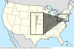 |
| May 10, 1922 | Kingman Reef was formally annexed.[332] | no change to map |
| October 8, 1923 | Michigan expanded its claim to Wisconsin territory, though Wisconsin never lost control over the area.[302] | 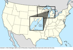 |
| November 15, 1923 | The Swan Islands were claimed by Honduras.[333] | Caribbean Sea: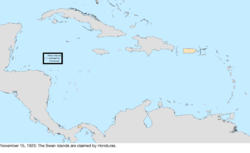 |
| February 1, 1924 | The future area for Madden Lake was annexed to the Panama Canal Zone under the United States right of expropriation in the 1903 Canal Treaty.[294][334][335] | Caribbean Sea: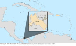 |
| March 4, 1925 | Swains Island was added to American Samoa.[336] | Pacific Ocean: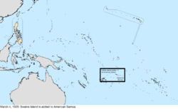 |
| July 17, 1925 | The border with Canada was adjusted in several places.[337][338] The only change to a land border redefined how the border between the Lake of the Woods and the Rocky Mountains should be considered; previously, the border followed the curve of the parallel between each border monument, while the treaty changed this to straight lines between each monument. Through this, the United States netted a gain of between 30 and 35 acres of land. Due to the extremely small shift, the lack of specific documentation of where the changes occurred, and the lack of any human impact, this change is not mapped. There was also a change to the border in the Lake of the Woods; due to inaccurate surveying, the previous border intersected itself several times in the lake, creating enclaves of United States water surrounded by Canadian water. The treaty changed the border to use the southernmost intersection as the northwestern point of the Lake of the Woods. Finally, the maritime border in the Bay of Fundy was adjusted, netting Canada roughly 9 acres of water. | too small to map |
| March 1, 1926 | The Supreme Court of the United States resolved the conflict between Michigan and Wisconsin in the favor of Wisconsin.[302] |  |
| July 29, 1926 | Johnston Atoll was established as a federal bird refuge and placed under the jurisdiction of the United States Department of Agriculture.[339] The atoll had originally been claimed by both the United States and Hawaii in in 1858, but little activity apart from guano mining had taken place, and it had been largely abandoned for decades.[190] | no change to map |
| November 22, 1926 | The Supreme Court of the United States defined the border between Michigan and Wisconsin, transferring all islands south of the Quinnesec Falls on the Menominee River to Wisconsin, and all islands north of the falls to Michigan; it is unknown specifically which islands were transferred in this fashion. However, an error in the border description introduced a small overlap between the two states over several islands in Lake Michigan north of the Door Peninsula.[340] |  |
| July 18, 1927 | The United States expropriated from Panama another 33 hectares of land on the islands of Taboga and Taboguilla and annexed them to the Panama Canal Zone.[316] | too small to map |
| October 26, 1927 | Two bancos along the Colorado River were ceded from Mexico to Arizona.[341][342] | too small to map |
| December 5, 1927 | The "Country Club Dispute" between New Mexico and Texas was resolved in Texas's favor.[343] | 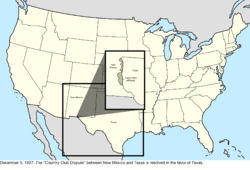 |
| April 4, 1928 | The Island of Palmas Case was decided in the favor of the Netherlands, ceding Palmas to the Dutch East Indies.[282] | Pacific Ocean: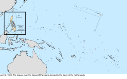 |
| September 24, 1928 | The United States expropriated from Panama three hectares of land at El Cerro de Doscientos Pies ("200-Foot Hill") near Las Minas Bay and annexed it to the Panama Canal Zone.[316][323] | too small to map |
| July 22, 1930 | The United States expropriated from Panama 25 hectares on Jicarita Island and 60 hectares at Punta Morro de Puercos and annexed them to the Panama Canal Zone.[316] | too small to map |
| April 15, 1931 | The United States expropriated from Panama additional areas around the soon-to-be-built Madden Dam and annexed them to the Panama Canal Zone.[316][323] | Caribbean Sea: |
| May 3, 1932 | The United States adjusted the border at Punta Paitilla in the Canal Zone, returning a small amount of land to Panama. This was the site for a planned new American embassy, which had to be built on foreign soil.[344] | too small to map |
| May 17, 1932 | Porto Rico was renamed Puerto Rico.[345] | Caribbean Sea: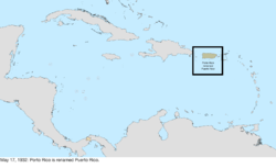 |
| December 13, 1932 | The Mangsee Islands and seven of the Turtle Islands were ceded by the United Kingdom from North Borneo to the Philippines. The islands were supposed to be included in the 1900 transfer of islands from Spain to the United States. Per the terms of the treaty, the United Kingdom continued to administer the islands until requested, and after its independence, the Philippine government made such a request and took control.[346] | Pacific Ocean: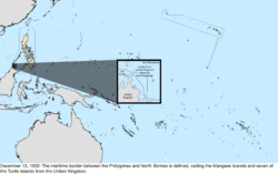 |
| November 13, 1933 | A treaty created the Rio Grande Rectification Project, which, from 1935 to 1938, straightened and stabilized the path of the Rio Grande through the El Paso–Juárez Valley. By the end of the project, 174 parcels had been transferred between Mexico and Texas, each side receiving an equal area of land.[347][348] | too small to map |
| December 29, 1934 | Kingman Reef was placed under the jurisdiction of the United States Department of the Navy.[332] | no change to map |
| March 16, 1936 | The de jure overlap between Michigan and Wisconsin was resolved by the Supreme Court of the United States.[349] | 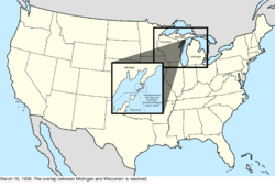 |
| May 13, 1936 | Baker Island, Howland Island, and Jarvis Island were formally annexed and placed under the jurisdiction of the United States Department of the Interior,[350] ending the United Kingdom's claim to Jarvis Island.[227] | Pacific Ocean: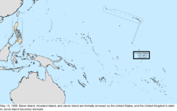 |
| June 22, 1936 | The U.S. Virgin Islands were organized into a civil territory.[351] | no change to map |
| August 6, 1936 | Canton Island, Enderbury Island, and McKean Island were claimed by the United Kingdom.[227] | Pacific Ocean: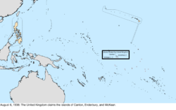 |
| April 6, 1939 | The condominium of the Canton and Enderbury Islands was established with the United Kingdom.[352] | Pacific Ocean: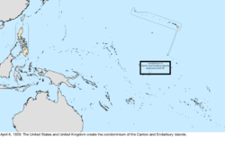 |
| July 27, 1939 | Panama gained a sovereign corridor that was carved out of the Panama Canal Zone connecting Colón with the rest of Panama, along with a three-dimensional "tube" of sovereignty for a future crossing over an American highway. A corridor consisting of the road from the Canal Zone boundary to Madden Dam was annexed to the Canal Zone.[353] | Caribbean Sea: |
| August 16, 1939 | This is the earliest date so far discovered for when the United States began claiming Fakaofo, Funafuti, Hull Island, Niulakita, Nukufetau, and Nukulaelae.[354] | Pacific Ocean: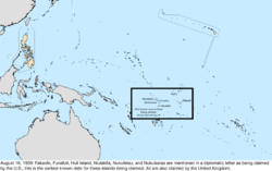 |
| December 10, 1941 | Governor George McMillin surrendered Guam to the Japanese military.[355] | Pacific Ocean: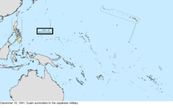 |
| December 23, 1941 | The garrison on Wake Island surrendered to the Japanese military.[356] | Pacific Ocean: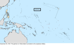 |
| March 26, 1942 | The government of the Commonwealth of the Philippines evacuated from the territory in the face of Japanese advance. A government-in-exile would be established in Washington, D.C. on May 17, 1942. The United States Army Forces in the Far East would surrender on April 9, 1942, following the Battle of Bataan, and the final military holdouts would surrender on May 6, 1942, following the Battle of Corregidor.[357] | Pacific Ocean: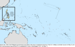 |
| October 14, 1943 | The Second Philippine Republic was established as a puppet state of Japan.[357] | Pacific Ocean: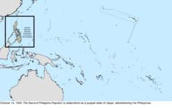 |
| August 10, 1944 | Guam was captured from Japan.[355] | Pacific Ocean: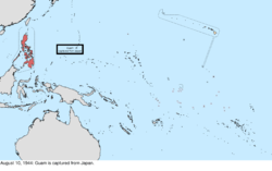 |
| August 17, 1945 | The Second Philippine Republic, in exile in Tokyo since April 3, 1945, was dissolved. The process of re-establishing the Commonwealth government on Philippine soil had started on October 23, 1944.[357] | Pacific Ocean: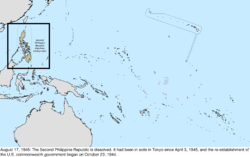 |
| September 4, 1945 | The Japanese garrison on Wake Island surrendered to the United States.[356] | Pacific Ocean: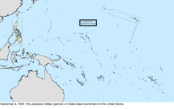 |
| July 4, 1946 | The Commonwealth of the Philippines became independent as the Republic of the Philippines.[358] | Pacific Ocean: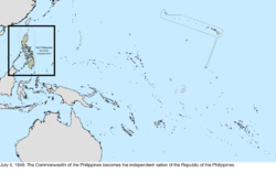 |
| July 18, 1947 | The United Nations entrusted the Trust Territory of the Pacific Islands to the United States.[359] | Pacific Ocean: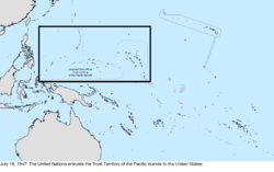 |
| January 1, 1949 | The Tokelau Islands were incorporated into New Zealand, which inherited the claims on Atafu, Fakaofo, and Nukunono.[360] | Pacific Ocean: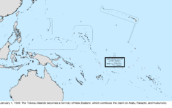 |
| August 1, 1950 | Guam was organized into a civil territory.[361][362] | no change to map |
| August 3, 1950 | Kansas and Missouri exchanged small portions of land along the Missouri River, due to shifts in the river following a flood in 1944.[363] | 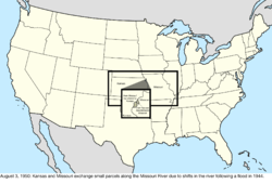 |
| April 11, 1955 | Panama's corridor connecting Colón with the rest of Panama was realigned within the Panama Canal Zone. Several three-dimensional "tubes" of sovereignty were also created, allowing Panamanian bridges to pass over rivers and a highway at several locations within the Canal Zone.[364][365] | too small to map |
| August 23, 1955 | Several border locations of the Panama Canal Zone were redefined. Punta Paitilla, the land held on Taboga Island, and the remaining American holdings in Colón and Panama City were ceded to Panama.[294][366] | Caribbean Sea: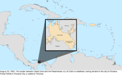 |
| January 3, 1959 | The Alaska Territory was admitted as the forty-ninth state, Alaska.[367] | Northwestern North America: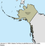 |
| August 21, 1959 | Most of Hawaii Territory was admitted as the fiftieth state, Hawaii. Palmyra Atoll was excluded from statehood and remained a territory.[216][368] | Pacific Ocean: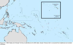 |
| August 25, 1961 | About 20 acres of land was transferred from Minnesota to North Dakota near Fargo, North Dakota;[160][369] since the area was very small and poorly documented, it is not mapped. | too small to map |
| January 14, 1964 | The Chamizal, a tract of land between El Paso, Texas, and Ciudad Juárez, Chihuahua, was divided between the United States and Mexico.[370] | 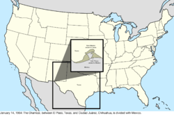 |
| August 4, 1965 | The Cook Islands became self-governing from New Zealand. It claimed the atolls of Pukapuka, Manihiki, Penrhyn, and Rakahanga.[371] | Pacific Ocean: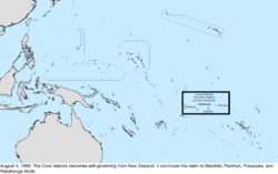 |
| July 14, 1970 | The lease of the Corn Islands from Nicaragua was terminated.[312] | no change to map |
| September 1, 1972 | The Swan Islands were ceded to Honduras.[312][372] | Caribbean Sea: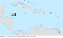 |
| May 26, 1977 | Several parcels were exchanged between Texas and Mexico along the Rio Grande in areas near Presidio and Hidalgo, Texas,[373] including the Horcón Tract, on which the town of Río Rico was located,[374] and Beaver Island near Roma, Texas. Mexico ceded 823 acres (3.33 km2) to the U.S., while the U.S. ceded 2,177 acres (8.81 km2) to Mexico, primarily to straighten sections of the Rio Grande for flood control.[375] | 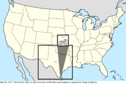 |
| October 1, 1978 | Tuvalu became independent from the United Kingdom. It claimed the atolls of Funafuti, Nukufetau, Nukulaelae, and Niulakita.[376] | Pacific Ocean: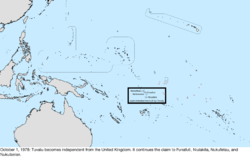 |
| July 12, 1979 | The Republic of Kiribati became independent from the United Kingdom. It claimed Birnie Island, Canton Island, Caroline Island, Christmas Island, Enderbury Island, Flint Island, Gardner Island, Hull Island, Malden Island, McKean Island, Phoenix Island, Starbuck Island, Sydney Island, and Vostok Island. This dissolved the condominium of the Canton and Enderbury Islands.[377] | Pacific Ocean: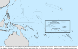 |
| October 1, 1979 | The Panama Canal Zone was ceded to Panama. The United States and Panama continued to share operational control of the canal until December 31, 1999, when it would be fully turned over to Panama.[378] The United States retained control over several hundred specified areas to be turned over in piecemeal fashion over the years. | Caribbean Sea: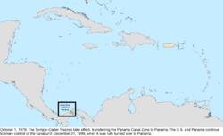 |
| November 24, 1980 | The maritime border between the United States and Venezuela was defined.[379] | no change to map |
| September 17, 1981 | Roncador Bank and Serrana Bank were ceded to Colombia, and the claim on Quita Sueño Bank was abandoned by the United States, as it was no longer above the seas at high tide, and thus the government considered it unclaimable.[312][380] | Caribbean Sea: |
| September 3, 1983 | Atafu, Fakaofo, and Nukunono were ceded to New Zealand.[312][381] | Pacific Ocean: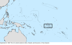 |
| September 8, 1983 | Pukapuka, Manihiki, Penrhyn, and Rakahanga were ceded to the Cook Islands.[312][382] | Pacific Ocean: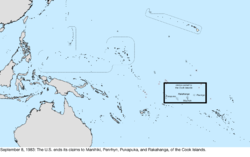 |
| September 23, 1983 | Birnie Island, Canton Island, Caroline Island, Christmas Island, Enderbury Island, Flint Island, Gardner Island, Hull Island, Malden Island, McKean Island, Phoenix Island, Starbuck Island, Sydney Island, and Vostok Island were ceded to Kiribati.[312][383]
Funafuti, Nukufetau, Nukulaelae, and Niulakita were ceded to Tuvalu.[312][384] |
Pacific Ocean: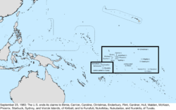 |
| October 12, 1984 | The International Court of Justice made its judgment on where the maritime border should be in the Gulf of Maine between the United States and Canada.[385] No land changed hands. The scope of the case did not include the sovereignty of Machias Seal Island, but the judgment enabled defining the extent of the disputed water area around that island (an area of 210 nm2).[144] | no change to map |
| October 21, 1986 | The Marshall Islands District of the Trust Territory of the Pacific Islands became independent as the Republic of the Marshall Islands.[386] The Marshall Islanders had claimed Wake Island as part of their territory since at least 1973, and continued that after independence.[387] | Pacific Ocean: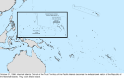 |
| November 3, 1986 | Most of the Trust Territory of the Pacific Islands was dissolved by the United Nations. The districts of Chuuk, Pohnpei, and Yap became independent as the Federated States of Micronesia. The Mariana Islands District, having already been taking moves towards integration with the United States, became a territory of the United States, the Commonwealth of the Northern Mariana Islands.[386] | Pacific Ocean: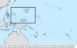 |
| June 1, 1990 | The maritime border between the United States and the Soviet Union was provisionally defined. The two countries agreed on this date to abide by the terms of the treaty pending its ratification and entry into force,[388] but while it was ratified by the United States Senate on September 16, 1991,[389] it is unknown if either the Soviet Union or its successor state, Russia, ratified it. | no change to map |
| October 1, 1994 | The remaining district of the Trust Territory of the Pacific Islands, the Palau District, became independent as the Republic of Palau, dissolving the TTPI.[390] | Pacific Ocean: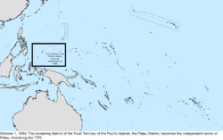 |
| June 1, 1995 | The maritime border between the United States and territories of the United Kingdom in the Caribbean Sea was defined.[391][392] | no change to map |
| January 16, 1997 | Navassa Island was transferred to the United States Department of the Interior.[393][394] | no change to map |
| November 13, 1997 | The maritime border between the United States and Mexico was defined.[395] | no change to map |
| December 31, 1999 | All former Panama Canal Zone parcels not turned over since 1979, as well as all joint canal operations areas, were transferred to Panama. | too small to map |
| January 17, 2001 | The maritime border between the United States and Mexico on the continental shelf in the western Gulf of Mexico beyond 200 nautical miles was defined.[396] | no change to map |
| November 24, 2009 | Six islands along the Rio Grande were ceded from Texas to Mexico, and 3 islands and 2 bancos were ceded from Mexico to Texas. The transfer, which had been pending for 20 years, was the first application of Article III of the 1970 Boundary Treaty.[342][397] | too small to map |
| September 23, 2014 | The maritime border between the United States and Niue was defined.[398] The treaty was signed on May 13, 1997, but it was not ratified by the United States until at least 2002, and the United Nations shows it as entering into force on this date.[399] | no change to map |
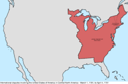
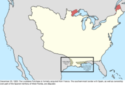
Bancos along the Rio Grande
The Banco Convention of 1905 between the United States and Mexico[400] allowed, in the event of sudden changes in the course of the Rio Grande (as by flooding), for the border to be altered to follow the new course. The sudden changes often created bancos, land left behind when curves in the river are cut off by rapid erosion of the channel or are intentionally cut to re-align it. When these bancos are created, the International Boundary and Water Commission investigates if land previously belonging to the United States or Mexico is to be considered on the other side of the border.[401] In all cases of these adjustments under the 1905 convention, which occurred on 37 different dates from 1910 to 1976, the transferred land was minuscule (ranging in size from 1 acre to 646 acres) and uninhabited. Indeed, some of the early bancos that were exchanged (including several created by floods in the mid-19th century) sustained further boundary adjustments from later avulsive changes and river straightening projects. Due to this fact and the small sizes of ceded land, these changes are not listed here; please see the articles linked above for more detail. This information is also available as a kmz file mapped at this location.
See also
- 51st state
- Geography of the United States
- Historic regions of the United States
- List of U.S. states by date of statehood
- Manifest destiny
- National Atlas of the United States
- State of Franklin
- Territorial evolution of U.S. states:
- Territorial evolution of Arizona
- Territorial evolution of California
- Territorial evolution of Colorado
- Territorial evolution of Idaho
- Territorial evolution of Montana
- Territorial evolution of Nevada
- Territorial evolution of New Mexico
- Territorial evolution of North Dakota
- Territorial evolution of Oregon
- Territorial evolution of South Dakota
- Territorial evolution of Texas
- Territorial evolution of Utah
- Territorial evolution of Washington
- Territorial evolution of Wyoming
- Territories of the United States on stamps
- United States territorial acquisitions
References
- ↑ "Articles of Confederation". The Avalon Project at Yale Law School. Retrieved October 31, 2015.
- 1 2 3 4 5 6 7 "Nine Capitals of the United States". U.S. Senate. Retrieved March 19, 2016.
- ↑ "The North Carolina - South Carolina Border Surveys - 1730 to 1815". Retrieved December 30, 2015.
- ↑ Kelly, Stephen R. (2014-08-23). "How the Carolinas Fixed Their Blurred Lines". The New York Times. Retrieved December 30, 2015.
- 1 2 3 "Virginia-Tennessee Border". Retrieved January 4, 2016.
- ↑ Vermont State Papers, pp. 136-137: "Agreeably to the recommendation of the committees, the Legislature of Vermont was adjourned to the first Wednesday of April [1781]; at which time, it met at Windsor, and the union of the grants, east and west of Connecticut river, was consummated"
- 1 2 "The Historical Geography of Vermont". Retrieved January 24, 2016.
- 1 2 3 4 5 Van Zandt, Franklin (1966). United States Geological Survey Bulletin 1212: Boundaries of the United States and the Several States. pp. 64–65. Retrieved June 30, 2015.
- 1 2 "East Union". The Vermont Encyclopedia. University Press of New England. 2003. p. 111. ISBN 9781584650867. 1584650869.
- ↑ Vermont State Papers, pp. 138-141
- 1 2 "West Union". The Vermont Encyclopedia. University Press of New England. 2003. p. 319. ISBN 9781584650867. 1584650869.
- ↑ Vermont v. New Hampshire, 289 U.S. 593 (1933)
- ↑ "Virginia's Cession of the Northwest Territory". Retrieved June 21, 2016.
- ↑ Spencer, Jesse Ames (1912). The United States: its beginnings, progress and modern development, Volume 3. Retrieved January 14, 2016.
- ↑ Van Zandt, pp. 74-79
- ↑ Gnichtel, Frederick W. (1921). "The "Pennamite Wars" and the Trenton Decree of 1782". Proceedings of the New Jersey Historical Society. 6. Retrieved November 8, 2015.
- ↑ Worthing C. Ford; et al. (eds.). Journals of the Continental Congress, 1774-1789. pp. Vol. 26, pp. 112–121.
- ↑ Van Zandt, pp. 92-95
- ↑ Treaty of Paris, 1783; International Treaties and Related Records, 1778-1974; General Records of the United States Government, Record Group 11; National Archives.
- ↑ McGee, Gentry Richard (1911). A History of Tennessee from 1663 to 1914: For Use in Schools. pp. 95–99. Retrieved December 29, 2015.
- ↑ Williams, Samuel C. (1933). History of the Lost State of Franklin. p. 30.
- 1 2 3 4 Van Zandt, pp. 65-71
- ↑ Van Zandt, pp. 72-74
- ↑ Van Zandt, pp. 47-49
- ↑ Northwest Ordinance, July 13, 1787; (National Archives Microfilm Publication M332, roll 9); Miscellaneous Papers of the Continental Congress, 1774-1789; Records of the Continental and Confederation Congresses and the Constitutional Convention, 1774-1789, Record Group 360; National Archives.
- ↑ Worthington C. Ford; et al. (eds.). Journals of the Continental Congress, 1774-1789. pp. Vol. 33, pp. 466–477.
- ↑ "Ratification of the Constitution by the State of Delaware; December 7, 1787". The Avalon Project at Yale Law School. Retrieved October 31, 2015.
- ↑ "Ratification of the Constitution by the State of Pennsylvania; December 12, 1787". The Avalon Project at Yale Law School. Retrieved October 31, 2015.
- ↑ "Ratification of the Constitution by the State of New Jersey; December 18, 1787". The Avalon Project at Yale Law School. Retrieved October 31, 2015.
- ↑ "Ratification of the Constitution by the State of Georgia; January 2, 1788". The Avalon Project at Yale Law School. Retrieved October 31, 2015.
- ↑ "Ratification of the Constitution by the State of Connecticut; January 8, 1788". The Avalon Project at Yale Law School. Retrieved October 31, 2015.
- ↑ "Ratification of the Constitution by the State of Massachusetts; February 6, 1788". The Avalon Project at Yale Law School. Retrieved October 31, 2015.
- ↑ "Ratification of the Constitution by the State of Maryland; April 28, 1788". The Avalon Project at Yale Law School. Retrieved October 31, 2015.
- ↑ "Ratification of the Constitution by the State of South Carolina; May 23, 1788". The Avalon Project at Yale Law School. Retrieved October 31, 2015.
- ↑ "Ratification of the Constitution by the State of New Hampshire; June 21, 1788". The Avalon Project at Yale Law School. Retrieved October 31, 2015.
- ↑ "Ratification of the Constitution by the State of Virginia; June 26, 1788". The Avalon Project at Yale Law School. Retrieved October 31, 2015.
- ↑ "Ratification of the Constitution by the State of New York; July 26, 1788". The Avalon Project at Yale Law School. Retrieved October 31, 2015.
- ↑ Williams, Samuel C. (1933). History of the Lost State of Franklin. p. 230.
- ↑ 1 Stat. 50
- ↑ "Ratification of the Constitution by the State of North Carolina; November 21, 1789". The Avalon Project at Yale Law School. Retrieved October 31, 2015.
- ↑ 1 Stat. 106
- 1 2 3 Van Zandt, pp. 109-111
- ↑ 1 Stat. 123
- ↑ "Ratification of the Constitution by the State of Rhode Island; May 29, 1790". The Avalon Project at Yale Law School. Retrieved October 30, 2015.
- ↑ 1 Stat. 191
- ↑ 1 Stat. 130, 1 Stat. 214
- 1 2 3 Van Zandt, pp. 88-92
- ↑ Tindall, William (February 25, 1919). "Naming the Seat of Government of the United States: A Legislative Paradox". Records of the Columbia Historical Society. Historical Society of Washington, D.C. 23: 10–25. JSTOR 40067136.
- ↑ Van Zandt, pp. 80-84
- ↑ Virginia Compacts, § 1-307. Compact and boundary with Kentucky
- ↑ 1 Stat. 189
- ↑ Van Zandt, p. 111
- ↑ "Jay's Treaty". Library of Congress. Retrieved November 2, 2015.
- ↑ "Treaty of Friendship, Limits, and Navigation Between Spain and The United States; October 27, 1795". The Avalon Project at Yale Law School. Retrieved October 30, 2015.
- ↑ Van Zandt, p. 22
- ↑ 1 Stat. 491
- ↑ 1 Stat. 549
- 1 2 3 4 Van Zandt, pp. 105-106
- ↑ 2 Stat. 58
- 1 2 Van Zandt, pp. 114-115
- ↑ "The Acts of Union, 1800". Retrieved November 10, 2015.
- ↑ 2 Stat. 103
- ↑ 2 Stat. 56
- ↑ "Proclamation of President Adams Accepting the Political Rights over Western Reserve". Retrieved October 29, 2015.
- ↑ Van Zandt, pp. 100-104
- ↑ 2 Stat. 173
- ↑ Van Zandt, pp. 111-114
- ↑ Virginia v. Tennessee, 148 U.S. 503 (1893)
- 1 2 Van Zandt, pp. 23-26
- ↑ 2 Stat. 303
- ↑ 2 Stat. 283
- 1 2 3 Van Zandt, pp. 106-108
- ↑ 2 Stat. 309
- 1 2 3 Van Zandt, pp. 127-128
- ↑ 2 Stat. 331
- ↑ 2 Stat. 514
- 1 2 Van Zandt, pp. 116-117
- ↑ Higgs, Robert. ""Not Merely Perfidious but Ungrateful": The U.S. Takeover of West Florida". Independent Institute. Retrieved June 14, 2016.
- ↑ "Proclamation—Occupation of West Florida (October 27, 1810)". Miller Center of Public Affairs. Retrieved October 29, 2015.
- 1 2 Van Zandt, pp. 26-27
- ↑ Cox, Isaac Joslin (1918). The West Florida Controversy, 1798-1813 – a Study in American Diplomacy. Baltimore, Maryland: The Johns Hopkins Press.
- ↑ 2 Stat. 701
- ↑ 2 Stat. 734
- ↑ 2 Stat. 743
- 1 2 3 Van Zandt, pp. 117-118
- ↑ 2 Stat. 708
- ↑ Louisiana; Lislet, Louis Moreau (1828). A General Digest of the Acts of the Legislature of Louisiana: Passed from the Year 1804, to 1827, Inclusive. p. 9. Retrieved October 28, 2015.
- 1 2 "Detroit surrenders without a fight". The History Channel. Retrieved June 13, 2016.
- ↑ Farmer, Silas (1884), The History of Detroit and Michigan: Or, the Metropolis Illustrated, Detroit: S. Farmer, p. 224, OCLC 359750
- ↑ "Town History". Town of Brookville, Maryland. Retrieved June 13, 2016.
- ↑ 3 Stat. 289, 3 Stat. 399
- ↑ 3 Stat. 371
- 1 2 Van Zandt, pp. 108-109
- ↑ 3 Stat. 348, 3 Stat. 472
- ↑ Alabama Terr. Acts 1818, 1st session, pp. 17-18
- ↑ Burrage, Henry Sweetser (1919). Maine in the Northeastern Boundary Controversy. p. 78. Retrieved June 22, 2016.
- ↑ 3 Stat. 428, 3 Stat. 536
- ↑ 8 Stat. 248
- ↑ "Treaties in Force" (PDF). United States Department of State. Retrieved July 14, 2015.
- ↑ Van Zandt, pp.14-15
- ↑ 3 Stat. 493
- 1 2 3 4 Van Zandt, pp. 118-120
- ↑ 3 Stat. 489, 3 Stat. 608
- ↑ 3 Stat. 544
- ↑ Van Zandt, pp. 55-60
- ↑ 3 Stat. 565
- 1 2 3 Van Zandt, p. 165
- ↑ Rowland, Dunbar (1917). The Official and Statistical Register of the State of Mississippi, Volume 4. pp. 57–58. Retrieved November 23, 2015.
- ↑ Alabama Acts 1820, 2nd session, p. 92
- 1 2 "The United States Formally Takes Control of Florida (July 17, 1821)". State Library and Archives of Florida. Retrieved July 14, 2015.
- ↑ Wright, J. Leitch (1972). "Research Opportunities in the Spanish Borderlands: West Florida, 1781-1821". Latin American Research Review. Latin American Studies Association. 7 (2): 24–34. JSTOR 2502623. Wright also notes, "It was some time after 1785 before it was clearly established that Suwannee was the new eastern boundary of the province of Apalachee."
- ↑ 3 Stat. 545
- ↑ "Acta de Independencia del Imperio Mexicano". Retrieved October 31, 2015.
- ↑ 3 Stat. 654
- 1 2 Van Zandt, pp. 104-105
- ↑ 4 Stat. 40
- ↑ "Convention Between the United States of America and His Majesty the Emperor of All the Russias, Relative to Navigating, Fishing, Etc., in the Pacific Ocean". Retrieved January 3, 2016.
- ↑ 7 Stat. 311
- 1 2 Keedy, Edwin R. (January 1953). "The Constitutions of the State of Franklin, the Indian Stream Republic and the State of Deseret". University of Pennsylvania Law Review. University of Pennsylvania Law Review. 101 (4): 521–525. JSTOR 3309935.
- ↑ 4 Stat. 701
- ↑ British and Foreign State Papers. 1852. p. 444. Retrieved June 28, 2016.
- ↑ Ralph W. Steen, "TEXAS DECLARATION OF INDEPENDENCE," Handbook of Texas Online (http://www.tshaonline.org/handbook/online/articles/mjtce), accessed July 13, 2015. Uploaded on June 15, 2010. Modified on February 3, 2015. Published by the Texas State Historical Association.
- ↑ 5 Stat. 50
- ↑ 5 Stat. 10
- 1 2 3 Van Zandt, pp. 128-131
- ↑ "The Frostbitten Convention; or, How Michigan Ended the Toledo War and Became a State". Retrieved June 22, 2016.
- ↑ "Tratado Definitivo de Paz y Amistad" (PDF). Retrieved October 31, 2015.
- ↑ 5 Stat. 144
- ↑ 5 Stat. 34, 5 Stat. 802
- ↑ 5 Stat. 235
- 1 2 Van Zandt, pp. 131-133
- ↑ PA50#v=onepage&q&f=false An ACT defining the northern boundary line of this State, accessed July 12, 2015
- ↑ 5 Stat. 674
- ↑ "Text of "The Webster-Ashburton Treaty"". The Avalon Project at Yale Law School. Retrieved 2006-08-04.
- ↑ Van Zandt, pp. 17-18
- ↑ "Evolution of Michigan's Boundaries: The Minnesota Sliver". Michigan State University. Retrieved December 27, 2015.
- ↑ Text from Webster-Ashburton Treaty: "till the line thus run intersects the old line of boundary surveyed and marked by Valentine and Collins previously to the year 1774, as the 45th degree of north latitude, and which has been known and understood to be the line of actual division between the States of New York and Vermont on one side, and the British Province of Canada on the other"
- ↑ "Provisional and Territorial Records Guide - 1843 Map". Oregon State Archives. Retrieved March 12, 2016.
- ↑ 5 Stat. 742
- ↑ 9 Stat. 108
- ↑ Van Zandt, pp. 120-127
- ↑ "Text of "Treaty with Great Britain, in Regard to Limits Westward of the Rocky Mountains."". The Avalon Project at Yale Law School. Retrieved 2006-08-04.
- 1 2 Van Zandt, p. 18
- 1 2 3 4 Gray, David H. (Autumn 1997). "Canada's Unresolved Maritime Boundaries" (PDF). IBRU Boundary and Security Bulletin. pp. 61–67. Retrieved 2015-03-21.
- ↑ Lavash, Donald (2006). A Journey Through New Mexico History. p. 129. ISBN 9780865345416. Retrieved March 16, 2016.
- ↑ "New Mexico - Laws for the Government of the Territory of New Mexico; September 22, 1846". The Avalon Project at Yale Law School. Retrieved March 16, 2016.
- ↑ "(James S. Calhoun's Annotated Copy) Map of the Territory of New Mexico Made by Order of Brig. Gen. S.W. Kearny under Instructions from Lieut. W.H. Emory, U.S.T.E. by Lieut's J.W. Abert and W.G. Peck, U.S.T.E., 1846-7". 1850. Retrieved March 16, 2016.
- ↑ 9 Stat. 117
- ↑ 9 Stat. 35
- ↑ 9 Stat. 1000
- ↑ An ACT to extend the jurisdiction of the commonwealth of Virginia over the county of Alexandria
- ↑ 9 Stat. 233
- ↑ Williams, J. Fletcher. Henry Hastings Sibley: A Memoir. Minnesota Historical Society. pp. 277–281. Retrieved December 28, 2015.
- ↑ 9 Stat. 922
- 1 2 Van Zandt, pp. 28-29
- ↑ 9 Stat. 323
- 1 2 Van Zandt, pp. 153-155
- ↑ Missouri v. Iowa, 48 U.S. 660 (1849)
- ↑ 9 Stat. 403
- 1 2 3 Van Zandt, pp. 133-134
- ↑ Danver, Steven L (2013-04-25). "Young, Brigham". Encyclopedia of Politics of the American West. p. 675. ISBN 9781452276069. Retrieved January 28, 2016.
- ↑ 9 Stat. 452
- ↑ Van Zandt, pp. 151-153
- ↑ 9 Stat. 453
- 1 2 Van Zandt, pp. 159-160
- 1 2 Treaty between the United States of America and the United Kingdom Concerning the Boundary between the United States and the Dominion of Canada from the Atlantic Ocean to the Pacific Ocean, signed April 11, 1908; accessed June 30, 2015
- ↑ 9 Stat. 446
- 1 2 3 Van Zandt, pp. 160-165
- ↑ Deseret (1919). Laws and ordinances of the state of Deseret (Utah). p. Prefatory. Retrieved June 22, 2016.
- ↑ 10 Stat. 172
- 1 2 Van Zandt, pp. 155-156
- ↑ 10 Stat. 277
- 1 2 Van Zandt, pp. 138-139
- 1 2 3 4 Van Zandt, pp. 136-138
- ↑ Kenneth R. Turner, "No Man's Land," Encyclopedia of Oklahoma History and Culture, www.okhistory.org (accessed June 04, 2015).
- ↑ "Gadsden Purchase Treaty : December 30, 1853". The Avalon Project at Yale Law School. Retrieved June 3, 2015.
- ↑ 10 Stat. 575
- ↑ 10 Stat. 602
- ↑ Van Zandt, p. 70
- ↑ Report of the Regents of the University on the Boundaries of the State of New York, Volume II. 1884. pp. 219–223. Retrieved July 9, 2015.
- 1 2 3 4 5 6 7 8 9 10 11 12 13 14 15 Moore, John Bassett (1906). "A Digest of International Law as Embodied in Diplomatic Discussions, Treaties and Other International Agreements, International Awards, the Decisions of Municipal Courts, and the Writings of Jurists and Especially in Documents, Published and Unpublished, Issued by Presidents and Secretaries of State of the United States, the Opinions of the Attorneys-General, and the Decisons of Courts, Federal and State". Washington, DC: U.S. Government Printing Office. pp. 566–580.
- ↑ 11 Stat. 285
- ↑ 11 Stat. 383
- ↑ Barnard, Jeff (May 19, 1985). "California-Oregon Dispute : Border Fight Has Townfolk on Edge". Los Angeles Times. Associated Press.
Preliminary studies indicate that, as the result of an 1870 surveying error, Oregon has about 31,000 acres of California, while California has about 20,000 acres of Oregon.
- ↑ Turner, Wallace (March 24, 1985). "SEA RICHES SPUR FEUD ON BORDER". New York Times.
The border should follow the 42d parallel straight west from the 120th meridian to the Pacific. Instead it zigzags, and only one of the many surveyor's markers put down in 1868 actually is on the 42d parallel.
- ↑ Sims, Hank (June 14, 2013). "Will the North Coast Marine Protected Areas Spark a War With Oregon?". Lost Coast Outpost.
- ↑ California Department of Fish and Wildlife (1 Mar 2016). Map: Pyramid Point State Marine Conservation Area (PDF) (Map). California Department of Fish and Wildlife.
Available from: http://nrm.dfg.ca.gov/FileHandler.ashx?DocumentID=117182
- ↑ Kleber, John E. "Middleton Offset". The Kentucky Encyclopedia. p. 635. ISBN 0813128838. Retrieved October 28, 2015.
- ↑ "Tennessee-Kentucky border didn't turn out as straight as it was supposed to be" (PDF). Retrieved October 28, 2015.
- 1 2 "Departmental Manual". U.S. Department of the Interior Office of Insular Affairs. Retrieved July 15, 2016.
- 1 2 JSTOR 1832884
- 1 2 162 U.S. 1 (1896)
- ↑ "Vanishing of Sarah Ann, Tiny Pacific Island, Causes Scientists Much Worry". Washington: Lundington Daily News. Oct 16, 1932. p. 1. Retrieved 13 January 2010.
- 1 2 3 4 5 6 7 8 9 10 11 12 13 "Secession Ordinances of 13 Confederate States". University of Houston. Retrieved May 24, 2015.
- ↑ 12 Stat. 126
- ↑ Constitution for the Provisional Government of the Confederate States of America, accessed July 8, 2015
- ↑ 12 Stat. 172
- 1 2 Van Zandt, pp. 141-144
- ↑ An Act to admit Texas as a member of the Confederate States of America, accessed July 8, 2015
- ↑ 12 Stat. 239
- 1 2 3 Van Zandt, pp. 134-136
- ↑ 12 Stat. 209
- 1 2 3 Van Zandt, pp. 158-159
- ↑ "Ordinance of Secession of Arizona Territory". Retrieved June 22, 2016.
- ↑ An Act to admit the Commonwealth of Virginia as a member of the Confederate States of America, accessed July 8, 2015
- ↑ An Act to admit the State of Arkansas into the Confederacy, accessed July 8, 2015
- ↑ Navy Dept, United States; Rush, Richard (1922). Official Records of the Union and Confederate Navies in the War of the Rebellion. p. 103. Retrieved June 22, 2016.
- ↑ "Treaty with the Choctaw and Chickasaw". Retrieved May 23, 2015.
- ↑ Gibson, Arrell Morgan (1984). The History of Oklahoma. University of Oklahoma Press. p. 66. ISBN 9780806118833. Retrieved July 9, 2015.
- ↑ An Act to admit the State of North Carolina into the Confederacy, on a certain condition, accessed June 29, 2016
- ↑ Confederate Congress 1861, 1:272. (View the page cited)
- ↑ Colton, Ray Charles (1985). The Civil War in the Western Territories. University of Oklahoma Press. pp. 122–123. ISBN 0-8061-1902-0. Retrieved August 3, 2010.
- ↑ Confederate Public Law Session V, Chapter I; accessed May 22, 2015
- ↑ Confederate Public Law Session V, Chapter V; accessed May 22, 2015
- ↑ 11 Stat. 382
- 1 2 "Palmyra Atoll". Office of Insular Affairs. Retrieved July 8, 2015.
- ↑ 12 Stat. 575
- ↑ 12 Stat. 664
- ↑ 12 Stat. 808
- 1 2 Van Zandt, pp. 156-158
- ↑ 13 Stat. 731
- ↑ Van Zandt, pp. 95-96
- ↑ W.Va. Acts 1863, 1st sess., ch. 35, sec. 1/pp. 33–35
- ↑ W.Va. Acts 1863, 1st sess., ch. 90, sec. 1/pp. 103–105
- 1 2 Van Zandt, pp. 145-151
- ↑ 13 Stat. 85
- 1 2 3 4 5 6 7 8 9 10 11 12 13 "Chronology". Historical Dictionary of the British Empire. London: Rowman & Littlefield. 2015. pp. xix–xxxviii. ISBN 9780810875241. Retrieved July 4, 2015.
- ↑ 13 Stat. 749
- ↑ "Remaining Confederate Cabinet Dissolves". Kansas City Public Library. Retrieved May 21, 2015.
- 1 2 14 Stat. 43
- ↑ 14 Stat. 364
- ↑ Society, Nevada State Historical (1909). First Biennial Report of the Nevada Historical Society. p. 133. Retrieved May 21, 2015.
- ↑ 14 Stat. 820
- 1 2 3 "Acquisition Process of Insular Areas". United States Department of the Interior Office of Insular Affairs. Retrieved July 15, 2016.
- ↑ Austin, Erik W.; Clubb, Jerome M. (1986). Political Facts of the United States Since 1789. Columbia University Press. p. 76. ISBN 9780231060943. Retrieved July 6, 2015.
- ↑ "Treaty concerning the Cession of the Russian Possessions in North America by his Majesty the Emperor of all the Russias to the United States of America". The Avalon Project at Yale Law School. Retrieved 2006-08-04.
- 1 2 Van Zandt, p. 32
- ↑ 15 Stat. 72
- ↑ Act authorizing readmission on ratification of 14th amendment: 15 Stat. 73. Florida ratified the amendment before that law was passed, so Florida was readmitted upon passage of the law.
- ↑ Act authorizing readmission on ratification of 14th amendment: 15 Stat. 73. Proclamation of North Carolina's ratification: 15 Stat. 703.
- ↑ Act authorizing readmission on ratification of 14th amendment: 15 Stat. 73. Proclamations of Louisiana's and South Carolina's ratification: 15 Stat. 704.
- ↑ Act authorizing readmission on ratification of 14th amendment: 15 Stat. 73. Proclamation of Alabama's ratification: 15 Stat. 704.
- ↑ Meyers, Christopher C. (2008). The Empire State of the South. ISBN 9780881461114. Retrieved May 19, 2015.
- ↑ 15 Stat. 178
- 1 2 Van Zandt, pp. 144-145
- ↑ "Wyoming History". State of Wyoming. Retrieved November 12, 2015.
- 1 2 Van Zandt, pp. 136, 149-150
- ↑ Chisholm, Hugh (1910). "Georgia". Encyclopedia Britannica. p. 757. Retrieved July 6, 2015.
- ↑ 16 Stat. 62
- ↑ 16 Stat. 67
- ↑ 16 Stat. 80
- ↑ 16 Stat. 363
- ↑ "Northwest Territories". The Canadian Encyclopedia. Retrieved July 6, 2015.
- ↑ 16 Stat. 93
- ↑ "British Columbia". The Canadian Encyclopedia. Retrieved July 6, 2015.
- ↑ "Vostok Island". Historical Dictionary of the British Empire. London: Rowman & Littlefield. 2015. pp. 561–562. ISBN 9780810875241. Retrieved July 2, 2015.
- ↑ 17 Stat. 464
- ↑ 18 Stat. 474
- ↑ "Union Islands". Historical Dictionary of the British Empire. London: Rowman & Littlefield. 2015. pp. 540–541. ISBN 9780810875241. Retrieved July 2, 2015.
- ↑ Van Zandt, pp. 85-88
- ↑ 21 Stat. 72
- ↑ "Flint Island". Historical Dictionary of the British Empire. London: Rowman & Littlefield. 2015. p. 191. ISBN 9780810875241. Retrieved July 2, 2015.
- ↑ 22 Stat. 35
- ↑ Watkins, Albert (1913). "Nebraska Territorial Acquisition". Collections of the Nebraska State Historical Society. Nebraska State Historical Society. XVII: 53. Retrieved May 18, 2015.
- ↑ Letters Patent... for the Annexation of Morant and Pedro Cays to the Island of Jamaica
- ↑ 23 Stat. 24
- 1 2 "Unknown title". United Empire. Royal Colonial Institute. 4: 266. 1914. Retrieved June 22, 2015.
- 1 2 3 25 Stat. 676
- ↑ 26 Stat. 81
- 1 2 3 Van Zandt, pp. 139-140
- ↑ 26 Stat. 215
- ↑ 26 Stat. 222
- ↑ 27 Stat. 640
- ↑ 28 Stat. 107
- ↑ 30 Stat. 214
- ↑ "Hawaii". Office of the Historian, Bureau of Public Affairs, United States Department of State. Retrieved May 14, 2015.
- ↑ 30 Stat. 750
- ↑ "U.S. Insular Areas: Application of the U.S. Constitution" (pdf). Report to the Chairman, Committee on Resources, House of Representatives. United States General Accounting Office. November 1997. Page 39, footnote 2.
- ↑ Report of the Hawaiian Commission, S. Doc. No. 16, 55th Cong., at 4 (3d Sess. 1898)
- ↑ "Wake Island Occupation". The New York Times. March 21, 1899. Retrieved May 14, 2015.
- ↑ "Treaty of Peace Between the United States and Spain; December 10, 1898". The Avalon Project at Yale Law School. Retrieved May 14, 2015.
- 1 2 Island of Palmas Case (Netherlands, USA), April 4, 1928; accessed June 2, 2015
- 1 2 3 4 "Treaties, Cessions, and Federal Laws". American Samoa Bar Association. Retrieved May 11, 2015.
- ↑ 31 Stat. 77
- ↑ 31 Stat. 141
- ↑ 31 Stat. 1465
- ↑ Va. Code Ann. § 1-306, Virginia Compacts - Boundary with Tennessee
- ↑ Map of the borders of the Treaty of Paris (1898)
- ↑ 31 Stat. 1942
- ↑ "Agreement Between the United States and Cuba for the Lease of Lands for Coaling and Naval stations; February 23, 1903". The Avalon Project at Yale Law School. Retrieved June 13, 2016.
- ↑ DuVal, Miles P. (1947). And the Mountains Will Move: The Story of the Building of the Panama Canal. Stanford University Press. ISBN 9780804711517. Retrieved May 12, 2015.
- ↑ 33 Stat. 2234
- ↑ Canal Zone Boundaries; signed June 15, 1904; accessed June 30, 2015
- 1 2 3 Van Zandt, pp. 58–60
- ↑ Committee On Appropriations, United States. Congress. House; Tawney, James A (1908). Hearings concerning estimates for construction of the Isthmian Canal for the fiscal year 1909. Retrieved July 6, 2015.
- ↑ H.R. Doc. No. 458 part 10, 58th Cong., 2nd Sess. (1904), pp. 936-941 (Specifically for this citation, sec. 5 on page 938)
- ↑ 33 Stat. 714
- ↑ Myers, Arther J.; Vosburg, David L. (November 1964). "Distances Within the State of Oklahoma" (PDF). Oklahoma Geology Notes. University of Oklahoma. 24 (11): 256. Retrieved May 17, 2015.
- ↑ 35 Stat. 2160
- ↑ Van Zandt, pp. 18-20
- ↑ International Boundary between the United States and the Dominion of Canada through the St. Lawrence River and Great Lakes, Sheet No. 12 - Niagara River (Map). Buffalo, New York: International Waterways Commission. August 15, 1913. Retrieved 2016-08-08.
- 1 2 3 Wisconsin v. Michigan, 270 U.S. 295 (1926)
- ↑ 36 Stat. 2477
- ↑ Van Zandt, p. 20
- ↑ "Who Owns Pope's Folly Island?". The New York Times. June 20, 1893. Retrieved May 11, 2015.
- ↑ Link to a download for the United States Geological Survey map of the Eastport Quadrangle from 1907:
- ↑ "Manu'a celebrates 105 years under the U.S. Flag". Samoa News. July 16, 2009. Archived from the original on December 5, 2013. Retrieved May 11, 2015.
- ↑ 37 Stat. 39
- ↑ 37 Stat. 1728
- ↑ 37 Stat. 512
- ↑ Bowden, J.J. (October 1959). "The Texas-New Mexico Boundary Dispute Along the Rio Grande" (PDF). Southwestern Historical Quarterly. Texas State Historical Association. 63 (2): 221–237. Retrieved May 11, 2015.
- 1 2 3 4 5 6 7 8 "Formerly Disputed Islands". U.S. Department of the Interior Office of Insular Affairs. Retrieved June 13, 2016.
- ↑ 38 Stat. 1893
- ↑ Canal Zone Boundaries, signed September 2, 1914; U.S. Treaty Series 610; accessed June 30, 2015
- ↑ "Boundary Convention". The Canal Record. Balboa Heights, Panama. June 9, 1915. Retrieved June 30, 2015.
- 1 2 3 4 5 6 7 8 McCain, William D. (1965). The United States and the Republic of Panama (2nd printing). New York: Russell & Russell. pp. 144–159.
- ↑ 39 Stat. 1763
- ↑ 39 Stat. 1706
- ↑ Van Zandt, pp. 39-40
- ↑ "Letter, Chester Harding (Governor of the Panama Canal Zone) to Luis Urriola (President of the Republic of Panama), July 12, 1918". Memoria que presenta el Secretario de Relaciones Exteriores a la Honorable Asamblea Nacional en sus Sesiones Ordinarias de 1918. Panama: Republic of Panama: 303–305. 1919.
- ↑ "The Panama Canal Record". XIII (39). Balboa Heights, Canal Zone: The Panama Canal. May 12, 1920. pp. 584–585.
... it was not until the year 1918, when the Governor of the Canal Zone addressed a communication to the Secretary of Foreign Affairs of the Republic of Panama stating that the United States Government would require 50.6 hectares, that the exact area expropriated was definitely known.
- ↑ Canal Zone. Office of the Governor. (1919). Annual Report of the Governor of the Panama Canal for the Fiscal Year ended June 30, 1919. Washington, DC: U.S. Government Printing Office. p. 94.
A survey was made and a map drawn up showing the boundary lines of the Punta Paitilla military reservation. Various areas were determined with reference to high and low water and the old and new city boundary lines. Permanent monuments were set and a description written up by metes and bounds. A tracing was made of the map of the military reservation known as area 'A'.
- 1 2 3 4 Panama Canal Zone and Vicinity Showing Judicial Districts (Map). National Archives, College Park, Maryland: United States Army. 1927. (with hand-drawn features dated 1932)
- ↑ 40 Stat. 959
- ↑ U.S. For. Rel., 1920, III, 314-322; Specifically, page 315, D-No. 60
- ↑ U.S. For. Rel., 1920, III, 314-322; Specifically, page 322, S.P.-No. 1362
- 1 2 Ecenbarger, Bill (August 30, 2001). Walkin' the Line: A Journey from Past to Present Along the Mason-Dixon. M. Evans and Company, Inc. pp. 89–91. ISBN 9781461710769. Retrieved May 10, 2015.
- ↑ Link to a download for the United States Geological Survey map of the Elkton Quadrangle from August 1900: . Note that later reprints of the same map, as early as 1906, changed ownership of the Wedge to Delaware:
- ↑ "Pub.Res. 7". 1921.
- 1 2 Hayes, J. Carroll (July 1923). "The Delaware Curve: The Story of the Pennsylvania-Delaware Circular Boundary". Pennsylvania Magazine of History and Biography. Historical Society of Pennsylvania. 47 (3). Retrieved May 10, 2015.
- ↑ "Refuse to be Expatriated: Citizens of Delaware Decline to Become Pennsylvanians". The New York Times. December 19, 1892. Retrieved May 10, 2015.
- 1 2 "Kingman Reef". Office of Insular Affairs. Retrieved July 15, 2016.
- ↑ Reply of the United States to the Honduran Claim of Sovereignty over the Swan Islands, accessed July 8, 2015
- ↑ Annual Report of the Governor of the Panama Canal for the Fiscal Year ended June 30, 1924 (PDF). Washington, DC: [U.S.] Government Printing Office. 1924. p. 13. Retrieved 2016-07-10.
- ↑ Exec. Order No. 4019 (June 5, 1924; in English) President of the United States. Retrieved on June 30, 2015.
- ↑ "Pub.Res. 75" (PDF). 1925.
- ↑ "Treaty Between Canada and the United States of America to define more accurately and to complete the International Boundary between the two Countries" (PDF). February 24, 1925. Retrieved May 8, 2015.
- ↑ Van Zandt, pp. 21-22
- ↑ Exec. Order No. 4467 (July 26, 1926; in English) President of the United States
- ↑ Wisconsin v. Michigan, 272 U.S. 398 (1926)
- ↑ "Minute 99: Re accretions lands on Colorado River-also Farmers and Fain Bancos.Decision reached." (PDF). International Boundary and Water Commission. October 26, 1927. Retrieved January 12, 2016.
- 1 2 "Minutes between the United States and Mexican Sections of the IBWC". International Boundary and Water Commission. Retrieved January 6, 2016.
- ↑ New Mexico v. Texas, 275 U.S. 279 (1927)
- ↑ 47 Stat. 145
- ↑ : Change of name; Puerto Rico
- ↑ 47 Stat. 2198
- ↑ American Water Resources Administration. p. 1027. Retrieved June 22, 2016.
- ↑ The details of the project are contained in IBWC minutes 145 through 167."Minutes 1 through 179". International Boundary and Water Commission. Retrieved June 22, 2016.
- ↑ Wisconsin v. Michigan, 297 U.S. 547 (1936)
- ↑ Exec. Order No. 7368 (May 13, 1936; in English) President of the United States
- ↑ 49 Stat. 1807
- ↑ Bevans, Charles Irving (1976). Treaties and Other International Agreements of the United States, Volume 12. Retrieved April 12, 2015.
- ↑ "Treaty of Friendship and Cooperation" (PDF). Library of Congress. Retrieved November 2, 2016.
- ↑ Foreign relations of the United States diplomatic papers, General, the British Commonwealth and Europe (1939). U.S. Department of State. 1939. pp. 317–319.
- 1 2 "Japanese Occupation of Guam". Guampedia. Retrieved April 12, 2015.
- 1 2 "Surrender of Wake Atoll, 4 September 1945". Naval History & Heritage Command. Retrieved April 11, 2015.
- 1 2 3 "71st Anniversary of the Second Philippine Republic". Republic of the Philippines Presidential Museum and Library. Retrieved April 11, 2015.
- ↑ "United Nations Treaty Series Volume 7" (PDF). Retrieved April 10, 2015.
- ↑ Exec. Order No. 11021 (July 1, 1962; in English) President of the United States. Retrieved on April 10, 2015.
- ↑ Tokelau Act 1948, NZ Pub Act 1948 No. 24; accessed July 2, 2015
- ↑ "Organic Act of Guam". Guampedia. Retrieved June 30, 2015.
- ↑ 64 Stat. 384
- ↑ 64 Stat. 397
- ↑ Convention between the United States of America and the Republic of Panama regarding the Colon Corridor and certain other corridors through the Canal Zone, signed May 24, 1950; UNTS 3430; accessed June 30, 2015
- ↑ Vinokurov, Evgeny (2007). Theory of Enclaves. Lexington Books, Lanham, MD. pp. 190–192. ISBN 9780739124031. Retrieved June 30, 2015.
- ↑ Treaty of mutual understanding and co-operation between the United States of America and the Republic of Panama, signed January 25, 1955; UNTS 3454; accessed June 30, 2015
- ↑ Van Zandt, pp. 165-166
- ↑ Van Zandt, p. 166
- ↑ 75 Stat. 399
- ↑ "Boundary: Solution of the Problem of the Chamizal" (PDF). International Boundary and Water Commission. August 29, 1963. Retrieved April 9, 2015.
- ↑ "Constitution of the Cook Islands" (PDF). Retrieved July 2, 2015.
- ↑ "Treaty on the Swan Islands" (PDF). Retrieved June 17, 2015.
- ↑ "Minutes between the United States and Mexican Sections of the IBWC". International Boundary and Water Commission.
Approvals: United States - May 26, 1977 [;] Mexico - May 26, 1977
- ↑ Rohter, Larry (September 26, 1987). "South of Border Was Once North". New York Times. Retrieved November 11, 2013.
- ↑ "Completion of the Relocations of the Rio Grande Stipulated in Article I of the Treaty of November 23, 1970 (Minute No. 257)" (PDF). International Boundary and Water Commission. May 18, 1977. Retrieved April 9, 2015.
- ↑ "Constitution of Tuvalu". Retrieved July 2, 2015.
- ↑ "Constitution of Kiribati". Government of Kiribati. 1979. Retrieved April 9, 2015.
- ↑ "The Panama Canal and the Torrijos-Carter Treaties". U.S. Department of State. October 31, 2013. Retrieved April 9, 2015.
- ↑ Maritime Boundary Treaty, signed March 28, 1978; UNTS 20984; accessed June 30, 2015
- ↑ "Treaty between the Government of the United States of America and the Government of the Republic of Colombia Concerning the Status of Quita Sueño, Roncador, and Serrana" (PDF). Retrieved June 17, 2015.
- ↑ "Treaty between the United States of America and New Zealand on the Delimitation of the Maritime Boundary between Tokelau and the United States of America" (PDF). pp. 251–267. Retrieved June 17, 2015.
- ↑ "Treaty between the United States of America and the Cook Islands" (PDF). June 11, 1980. Retrieved April 8, 2015.
- ↑ "Treaty of Friendship between the United States of America and the Republic of Kiribati" (PDF). pp. 239–250. Retrieved June 17, 2015.
- ↑ "Treaty of Friendship between the United States of America and Tuvalu" (PDF). pp. 79–84. Retrieved June 17, 2015.
- ↑ Case Concerning Delimitation of the Maritime Boundary in the Gulf of Maine Area (Canada v. United States), accessed June 30, 2015
- 1 2 Ronald Reagan (November 3, 1986). "Proclamation 5564: Placing Into Full Force and Effect the Covenant With the Commonwealth of the Northern Mariana Islands, and the Compacts of Free Association With the Federated States of Micronesia and the Republic of the Marshall Islands" (PDF). Government Publishing Office. Retrieved April 7, 2015.
- ↑ Anderson, Jon (February 8, 1973). "Wake Island Claimed By Marshall Islanders". The Cameron Herald. Cameron, Texas. Retrieved January 28, 2016.
- ↑ Agreement between the United States of America and the Union of Soviet Socialist Republics to abide by the terms of the Maritime Boundary Agreement of 1 June 1990, pending entry into force, signed June 1, 1990; UNTS 40300; accessed July 1, 2015
- ↑ Treaty 101-22
- ↑ "Palau Gains Independence on Saturday". Salt Lake City, Utah, USA: The Deseret News, via Google News. Associated Press. 30 September 1994.
- ↑ Treaty on the delimitation in the Caribbean of a maritime boundary relating to the U.S. Virgin Islands and Anguilla, signed May 11, 1993; UNTS 32636; accessed July 1, 2015
- ↑ Treaty on the delimitation in the Caribbean of a maritime boundary relating to Puerto Rico/U.S. Virgin Islands and the British Virgin Islands, signed May 11, 1993; UNTS 32637; accessed July 1, 2015
- ↑ Secretary's Orders 3205: Administration of Navassa Island, United States Secretary of the Interior Bruce Babbitt, signed January 16, 1997, accessed June 30, 2015
- ↑ Treaty on maritime boundaries between the United Mexican States and the United States of America, signed May 4, 1978; UNTS 37399; accessed June 30, 2015
- ↑ Treaty between the Government of the United Mexican States and the Government of the United States of America on the delimitation of the continental shelf in the western Gulf of Mexico beyond 200 nautical miles, signed June 9, 2000; UNTS 37400; accessed June 30, 2015
- ↑ "Minute 315: Adoption of the Delineation of the International Boundary on the 2008 Aerial Photographic Mosaic of the Rio Grande" (PDF). International Boundary and Water Commission. November 24, 2009. Retrieved June 13, 2016.
- ↑ Treaty 105-53
- ↑ "Treaty between the Government of Niue and the Government of the United States of America on the delimitation of a maritime boundary". United Nations. Retrieved June 30, 2015.
- ↑ "Convention Between the United States and Mexico for the Elimination of the Bancos in the Rio Grande from the Effects of Article II of the Treaty of November 12, 1884" (PDF). June 5, 1907. Retrieved April 19, 2015.
- ↑ Leon C. Metz, "BANCOS OF THE RIO GRANDE," Handbook of Texas Online (http://www.tshaonline.org/handbook/online/articles/rnb08), accessed July 13, 2015. Uploaded on June 12, 2010. Published by the Texas State Historical Association.
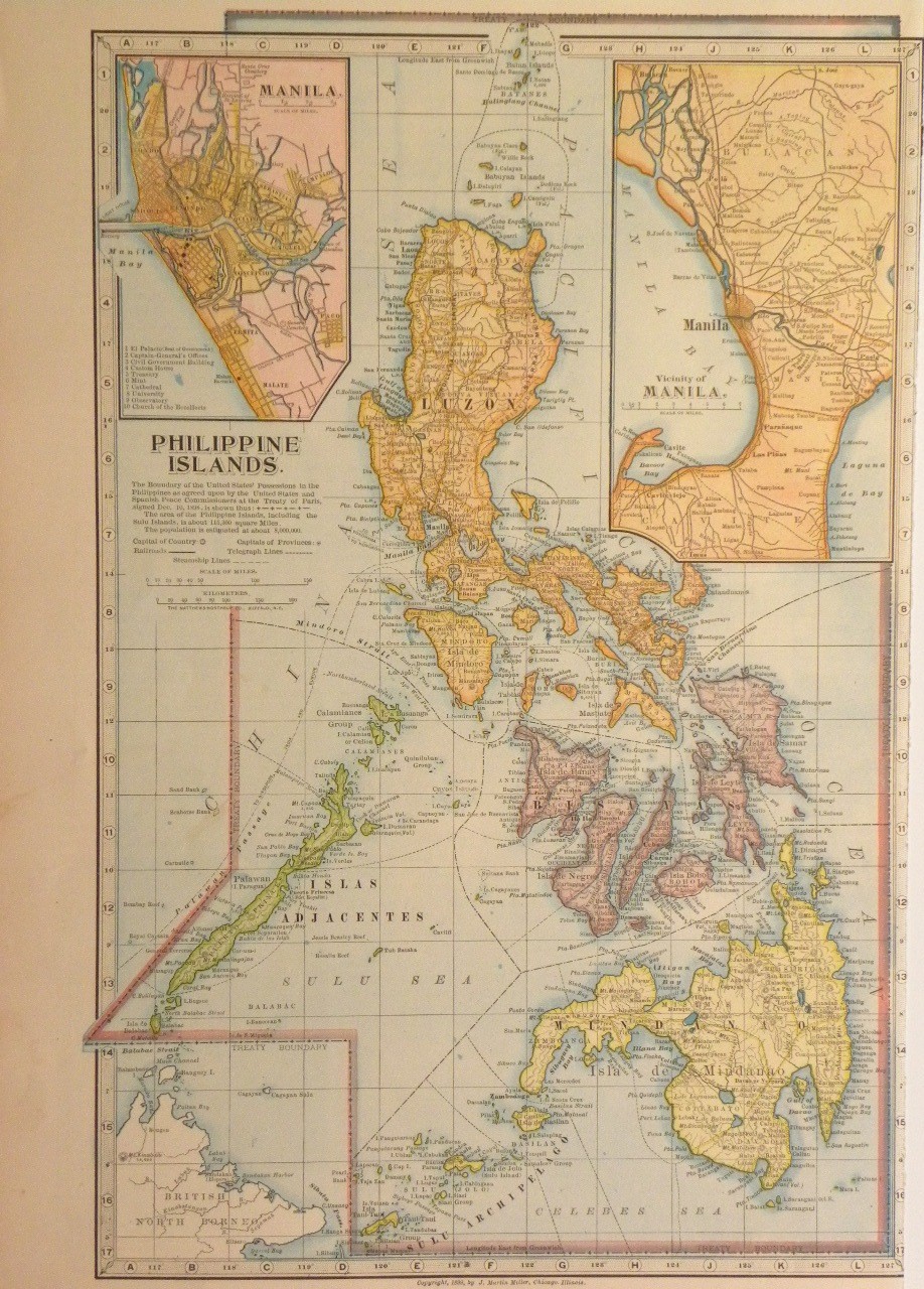
Further reading
- Van Zandt, Franklin K. (1976). Boundaries of the United States and the Several States: With Miscellaneous Geographic Information Concerning Areas, Altitudes, and Geographic Centers. Washington, D.C.: U.S. Government Printing Office. OCLC 69426475.
- Stein, Mark (2008). How the States Got Their Shapes. New York: Smithsonian Books/Collins. ISBN 978-0-06-143138-8. OCLC 137324984.
| By country | |
|---|---|
| By former country | |
| By region |
|
| By country, people, region and/or period | |
| By international organisation | |