Westminster St Margaret and St John
| St Margaret and St John St Margaret (until 1727) Westminster District (1855–1887) | |
|---|---|
| Civil parish | |
 | |
| Area | |
| • 1881 | 815 acres (3.30 km2) |
| • 1901 | 766 acres (3.10 km2) |
| • 1921 | 767 acres (3.10 km2) |
| • Coordinates | 51°29′58″N 0°08′00″W / 51.4995°N 0.1333°WCoordinates: 51°29′58″N 0°08′00″W / 51.4995°N 0.1333°W |
| Population | |
| • 1881 | 59,926 |
| • 1901 | 51,068 |
| • 1921 | 39,916 |
| Density | |
| • 1881 | 73.53/acre |
| • 1901 | 66.67/acre |
| • 1921 | 52.04/acre |
| History | |
| • Origin | Ancient parish |
| • Created | 10th century |
| • Abolished | 1922 |
| • Succeeded by | City of Westminster (parish) |
| Status | District (1855–1887) |
| Government |
St Margaret Vestry (16th century–1727) |
| • Type | Vestry |
| • HQ | Town Hall, Caxton Street |
 Seal of the united vestry in 1888 | |
| Contained within | |
| • City and liberty | Westminster (until 1900) |
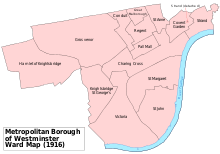
| • Metropolitan borough | Westminster (1900–1922) |
| • Poor Law Union |
St George's (1870–1913) City of Westminster (1913–1922) |
| Subdivisions | |
| • Type | Parishes (after 1727) |
| • Units |
St John St Margaret |
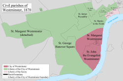
St Margaret was an ancient parish in the City and Liberty of Westminster and the county of Middlesex. It included the core of modern Westminster, including the Palace of Westminster and the area around, but not including Westminster Abbey. In 1727 it was divided into St Margaret's and St John's, to coincide with the building of the Church of St John the Evangelist, constructed by the Commission for Building Fifty New Churches in Smith Square to meet the demands of the growing population, but there continued to be a single vestry for the parishes of St Margaret and St John. This was reformed in 1855 by the Metropolis Management Act, and the two parishes formed the Westminster District until 1887. In 1889 St Margaret and St John became part of the County of London. The vestry was abolished in 1900, to be replaced by Westminster City Council, but St Margaret and St John continued to have a nominal existence until 1922.
Governance
St Margaret was an ancient parish, governed by a vestry and within the City and Liberty of Westminster. Before 1542 the parish included territory between the church of St Clement Danes and the Palace of Westminster, that became part of the parish of St Martin in the Fields.[1]
The Commission for Building Fifty New Churches was set up to build new churches for populous parishes in the London area and Church of St John the Evangelist was completed in 1728. To coincide with this, a new parish of St John the Evangelist for civil and ecclesiastical purposes was split off from St Margaret in 1727.
Despite the split, the two parishes continued to be governed by a single vestry and were commonly known as Westminster St Margaret and St John.[2]
The two parishes were grouped into the Westminster District in 1855 when they came within the area of responsibility of the Metropolitan Board of Works. St Margaret elected 30 members the district board and St John elected 27 members.
Under the Metropolis Management Act 1855 any parish that exceeded 2,000 ratepayers was to be divided into wards; as such the parishes of both St Margaret Westminster and St John the Evangelist within the Westminster District Boards of Works were divided into three wards each (electing vestrymen): St Margaret No. 1 (12), St Margaret No. 2 (9), St Margaret No. 3 (15), St John the Evangelist No. 1 (9), St John the Evangelist No. 2 (15) and St John the Evangelist No. 3 (12).[3][4]
The local authority was renamed as the St Margaret and St John Combined Vestry in 1887.[2]
In 1889 the parishes became part of the County of London. The united parishes unsuccessfully petitioned for incorporation as a municipal borough on 19 January 1897.[5] In 1900 they became part of the Metropolitan Borough of Westminster. St Margaret and St John was abolished as a civil parish in 1922.
Libraries
The parish vestry was the first in London to adopt the Public Libraries Act 1855. It held a public meeting in 1856, achieved the required two thirds in favour of providing a library and appointed a librarian the same year. The Westminster Public Library on Great Smith Street opened in 1857. In 1858 a further library was opened in Trevor Square, Knightsbridge.[6]
Geography
The main section of the combined territory fronted the River Thames, with the parish of St Margaret to the north and St John to the south. St Margaret also consisted of a detached portion to the west of the main territory around Kensington Palace and Knightsbridge.[7] The Close of the Collegiate Church of St Peter formed an extra-parochial enclave between the two parishes, containing Westminster Abbey.
Poor law
Westminster St Margaret and St John was a local act parish and so remained a single unit for administration of the New Poor Law. Following the Metropolitan Poor Act 1867, it joined with St George Hanover Square for this purpose in 1870 as the St George's Union.[8]
Population
The population history is typical for a central district of London, growing until the 19th century and then declining as transport improvements caused movement to the suburbs. The population peak was in 1871.
| Year | 1801 | 1811 | 1821 | 1831 | 1841 | 1851 | 1871 | 1881 | 1891 | 1901 | 1911 | 1921 |
|---|---|---|---|---|---|---|---|---|---|---|---|---|
| Population[9] | 17,508 | 19,202 | 22,568 | 25,529 | 30,489 | 31,314 | 66,050 | 59,926 | 55,539 | 51,068 | 47,692 | 39,916 |
References
- ↑ "Estate and Parish History | British History Online". British-history.ac.uk. Retrieved 2016-09-14.
- 1 2 Youngs, Frederic (1979). Guide to the Local Administrative Units of England. I: Southern England. London: Royal Historical Society. ISBN 0-901050-67-9.
- ↑ The London Gazette Issue: 21802. 20 October 1855. pp. 3900–3902. Retrieved 9 April 2015.
- ↑ "H.M.S.O. Boundary Commission Report 1885 Westminster Map". Vision of Britain. Retrieved 9 April 2015.
- ↑
- ↑ Encyclopedia of Library and Information Science: Volume 33 - The Wellesley College Library to Zoological Literature: A Review
- ↑ Port, M. H. (Edr.) (1986). "Illustrative map of London parishes". The Commissions for building fifty new churches: The minute books, 1711-27, a calendar. London Record Society.
- ↑ Peter Higginbotham. "St Margaret and St John the Evangelist, Westminster, London". Workhouses.org.uk.
- ↑ "Westminster St Margaret CP/AP through time | Population Statistics | Total Population". Visionofbritain.org.uk. Retrieved 2016-09-14.
| Districts |
|  Headquarters at Spring Gardens |
|---|---|---|
| Incorporated vestries | Original vestries (1855)
Later vestries
| |
| Undertakings | ||
| Major works | ||
| Legislation | ||
| People | ||
History of the formation of the City of Westminster | ||
|---|---|---|
| Metropolitan boroughs |  | |
| District boards | ||
| Parishes | ||
| Liberties | ||