Westminster (town), Vermont
| Westminster, Vermont | |
|---|---|
| Town | |
|
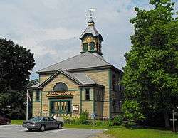
Westminster Town Hall | |
 Westminster, Vermont | |
| Country | United States |
| State | Vermont |
| County | Windham |
| Government | |
| • Town Clerk | Doreen Woodward[1] |
| Elevation | 89 ft (27 m) |
| Population (2010)[2] | |
| • Total | 3,210 |
| Time zone | Eastern (EST) (UTC-5) |
| • Summer (DST) | EDT (UTC-4) |
| ZIP code | 05158 |
| Area code(s) | 802 |
| Website | www.westminstervt.org/ |
Westminster is a town in Windham County, Vermont, United States. The population was 3,210 at the 2000 census.[2]
History
Westminster is Vermont's oldest existing town and was chartered in 1735.[3][4] The Court of Common Pleas (established 1768) of the County of Cumberland (established 3 July 1766) of the Province of New York was moved to the town of Westminster in 1772.[5] It was the site of the Westminster massacre in March 1775, in which two men were killed attempting to prevent New York provincial officials from exerting their authority over the area in the long-running dispute over the New Hampshire Grants.[6][7] On January 15, 1777, a group of Vermonters met in the Westminster courthouse to declare the independence of the Republic of New Connecticut (later renamed the Republic of Vermont).[8][9]
Geography
According to the United States Census Bureau, the town has a total area of 46.1 square miles (119.5 km2), of which 46.1 square miles (119.3 km2) is land and 0.04 square mile (0.1 km2) (0.06%) is water.
Demographics
| Historical population | |||
|---|---|---|---|
| Census | Pop. | %± | |
| 1790 | 1,601 | — | |
| 1800 | 1,942 | 21.3% | |
| 1810 | 1,925 | −0.9% | |
| 1820 | 1,974 | 2.5% | |
| 1830 | 1,737 | −12.0% | |
| 1840 | 1,546 | −11.0% | |
| 1850 | 1,721 | 11.3% | |
| 1860 | 1,300 | −24.5% | |
| 1870 | 1,238 | −4.8% | |
| 1880 | 1,377 | 11.2% | |
| 1890 | 1,265 | −8.1% | |
| 1900 | 1,295 | 2.4% | |
| 1910 | 1,327 | 2.5% | |
| 1920 | 1,289 | −2.9% | |
| 1930 | 1,324 | 2.7% | |
| 1940 | 1,403 | 6.0% | |
| 1950 | 1,400 | −0.2% | |
| 1960 | 1,602 | 14.4% | |
| 1970 | 1,875 | 17.0% | |
| 1980 | 2,493 | 33.0% | |
| 1990 | 3,026 | 21.4% | |
| 2000 | 3,210 | 6.1% | |
| 2010 | 3,178 | −1.0% | |
| Est. 2015 | 282 | [10] | −91.1% |
| U.S. Decennial Census[11] | |||
As of the census[12] of 2000, there were 3,210 people, 1,246 households, and 843 families residing in the town. The population density was 69.7 people per square mile (26.9/km2). There were 1,412 housing units at an average density of 30.6 per square mile (11.8/km2). The racial makeup of the town was 97.73% White, 0.40% Black or African American, 0.28% Native American, 0.22% Asian, 0.34% from other races, and 1.03% from two or more races. Hispanic or Latino of any race were 0.69% of the population.
There were 1,246 households out of which 34.6% had children under the age of 18 living with them, 55.5% were married couples living together, 8.8% had a female householder with no husband present, and 32.3% were non-families. 24.4% of all households were made up of individuals and 6.7% had someone living alone who was 65 years of age or older. The average household size was 2.58 and the average family size was 3.06.
In the town the population was spread out with 27.3% under the age of 18, 5.5% from 18 to 24, 29.8% from 25 to 44, 27.1% from 45 to 64, and 10.3% who were 65 years of age or older. The median age was 38 years. For every 100 females there were 95.0 males. For every 100 females age 18 and over, there were 93.1 males.
The median income for a household in the town was $44,263, and the median income for a family was $49,615. Males had a median income of $32,365 versus $26,303 for females. The per capita income for the town was $20,019. About 7.1% of families and 10.0% of the population were below the poverty line, including 10.8% of those under age 18 and 8.1% of those age 65 or over.
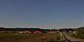 Westminster is mostly rural in nature
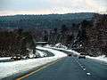 I-91 in Westminster
Notable people
- Jerome Allen, educator and author[13]
- Stephen R. Bradley, US Senator from Vermont[14]
- William Czar Bradley. U.S. Representative from Vermont[15]
- Edmund Burke, US Representative from Vermont[16]
- Joseph Dorr Clapp, Wisconsin State Senator, farmer, and businessman, was born in Westminster.[17]
- Hiram Pratt, mayor of Buffalo, N.Y.[18]
- Mark Richards, US Congressman and seventh Lieutenant Governor of Vermont[19]
See also
References
- ↑ "Town Clerk's Office". Westminster Vermont. Retrieved January 7, 2014.
- 1 2 "Vermont Census Counts and Intercensal PopulationEstimates 2000-2010" (PDF). healthvt.gov. Retrieved January 7, 2014.
- ↑ "Westminster Vermont Chartered 1735". Westminster Vermont. Retrieved January 7, 2014.
- ↑ Haas, Jessie (2012). Westminster, Vermont, 1735-2000: Township Number One. The History Press. p. 1.
- ↑ Collins, Anne L. (2007). Bellows Falls, Saxtons River and Westminster: A History of Vermont's Most Beloved River Communities. The History Press. p. 123.
- ↑ U.S. Government Printing Office (1903). Congressional Serial Set. U.S. Government Printing Office. p. 286.
- ↑ United States Congressional serial set. United States Congressional serial set. 1908. p. 52.
- ↑ Hass, Jessica (2012). Westminster, Vermont, 1735-2000: Township Number One. The History Press. p. 51.
- ↑ Conant, Edward (1915). A Text Book of the Geography, History, Constitution and Civil Government of Vermont: Also Constitution and Civil Government of the United States. A Publication Expressly Prepared to Comply with Vermont's State School Laws. Tutle Company. p. 191.
- ↑ "Annual Estimates of the Resident Population for Incorporated Places: April 1, 2010 to July 1, 2015". Retrieved July 2, 2016.
- ↑ "U.S. Decennial Census". United States Census Bureau. Retrieved May 16, 2015.
- ↑ "American FactFinder". United States Census Bureau. Retrieved 2008-01-31.
- ↑ Crowell, Edward Payson and Biscoe, Walter Stanley (1883). Biographical Record of the Alumni of Amherst College During Its First Half Century, 1821-1871. Edward Payson Crowell, Walter Stanley Biscoe. p. 245.
- ↑ "BRADLEY, Stephen Row, (1754 - 1830)". Biographical Directory of the United States Congress. Retrieved October 27, 2012.
- ↑ "BRADLEY, William Czar, (1782 - 1867)". Biographical Directory of the United States Congress. Retrieved October 30, 2012.
- ↑ "BURKE, Edmund, (1809 - 1882)". Biographocal Directory of the United States Congress. Retrieved January 3, 2014.
- ↑ 'Proceedings of the State Historical Society of Wisconsin at the Forth-eight session, December 11, 1900, Biographical Sketch of Joseph Dorr Clapp, pg. 95
- ↑ Pratt, Walter Wilcox (1900). The Ancestry and the Descendants of John Pratt of Hartford, Conn. Case, Lockwood & Brainard Company. p. 71.
- ↑ "RICHARDS, Mark, (1760 - 1844)". Biographical Directory of the United States Congress. Retrieved October 27, 2012.
External links
| Wikimedia Commons has media related to Westminster, Vermont. |
Coordinates: 43°04′29″N 72°30′31″W / 43.07472°N 72.50861°W
Municipalities and communities of Windham County, Vermont, United States | ||
|---|---|---|
| Towns |  | |
| Villages | ||
| CDPs | ||
| Other communities | ||
| Footnotes | ‡ Disincorporated | |