Westminster, Massachusetts
| Westminster, Massachusetts | ||
|---|---|---|
| Town | ||
|
Westminster Historic District | ||
| ||
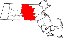
 Location in Worcester County and the state of Massachusetts. | ||
| Coordinates: 42°32′45″N 71°54′40″W / 42.54583°N 71.91111°WCoordinates: 42°32′45″N 71°54′40″W / 42.54583°N 71.91111°W | ||
| Country | United States | |
| State | Massachusetts | |
| County | Worcester | |
| Settled | 1737 | |
| Incorporated | 1759 | |
| Government | ||
| • Type | Open town meeting | |
| Area | ||
| • Total | 37.3 sq mi (96.7 km2) | |
| • Land | 35.5 sq mi (92.0 km2) | |
| • Water | 1.8 sq mi (4.7 km2) | |
| Elevation | 1,080 ft (329 m) | |
| Population (2010) | ||
| • Total | 7,277 | |
| • Density | 200/sq mi (75/km2) | |
| Time zone | Eastern (UTC-5) | |
| • Summer (DST) | Eastern (UTC-4) | |
| ZIP code | 01473 | |
| Area code(s) | 351 / 978 | |
| FIPS code | 25-77010 | |
| GNIS feature ID | 0618393 | |
| Website | http://www.westminster-ma.gov/ | |

Westminster is a town in Worcester County, Massachusetts, in the United States. At the 2010 census, the town population was 7,277.
History
Westminster was first settled in 1737, and was officially incorporated in 1759.
Westminster has four entries in the National Register of Historic Places:
- Ahijah Wood House — 175 Worcester Rd. (added October 17, 1987)
- Nathan Wood House — 164 Worcester Rd. (added October 16, 1987)
- Ezra Wood-Levi Warner Place — 165 Depot Rd. (added August 7, 1983)
- Westminster Village-Academy Hill Historic District — Bacon, Adams, Main, Dawley, Academy Hill, Leominster, and Pleasant Sts. (added July 23, 1983)
The District includes the following buildings:
- Miles, Daniel Curtis Place — 116 Main St. — c1855. (added October 29, 2006)
- Forbush Memorial Library — 118 Main St.— Built 1901; Dedicated 1902. (added October 29, 2006)
Westminster was the site of Westminster Academy, incorporated in 1833.
The town achieved national news in November 2014 when the Board of Health proposed banning all sales of tobacco. The meeting between the Board of Health and concerned citizens did not go well with citizens raising objections to the governmental over-reach. [1]
Geography
According to the United States Census Bureau, the town has a total area of 37.3 square miles (97 km2), of which 35.5 square miles (92 km2) is land and 1.8 square miles (4.7 km2), or 4.90%, is water.
Westminster is bordered by Ashburnham to the north, Gardner to the west, Hubbardston to the southwest, Princeton to the south, and Leominster and Fitchburg to the east.
Demographics
| Historical population | ||
|---|---|---|
| Year | Pop. | ±% |
| 1850 | 1,914 | — |
| 1860 | 1,840 | −3.9% |
| 1870 | 1,770 | −3.8% |
| 1880 | 1,652 | −6.7% |
| 1890 | 1,688 | +2.2% |
| 1900 | 1,327 | −21.4% |
| 1910 | 1,353 | +2.0% |
| 1920 | 1,343 | −0.7% |
| 1930 | 1,925 | +43.3% |
| 1940 | 2,126 | +10.4% |
| 1950 | 2,768 | +30.2% |
| 1960 | 4,022 | +45.3% |
| 1970 | 4,273 | +6.2% |
| 1980 | 5,139 | +20.3% |
| 1990 | 6,191 | +20.5% |
| 2000 | 6,907 | +11.6% |
| 2010 | 7,277 | +5.4% |
| * = population estimate. Source: United States Census records and Population Estimates Program data.[2][3][4][5][6][7][8][9][10][11] | ||
As of the census[12] of 2000, there were 6,907 people, 2,529 households, and 1,954 families residing in the town. The population density was 194.5 people per square mile (75.1/km²). There were 2,694 housing units at an average density of 75.9 per square mile (29.3/km²). The racial makeup of the town was 97.50% White, 0.46% African American, 0.14% Native American, 1.14% Asian, 0.14% from other races, and 0.61% from two or more races. Hispanic or Latino of any race were 1.11% of the population. 17.6% were of French, 15.0% Irish, 13.2% French Canadian, 9.0% English, 9.0% Italian, 8.5% Finnish and 5.6% American ancestry according to Census 2000.
There were 2,529 households out of which 36.9% had children under the age of 18 living with them, 65.8% were married couples living together, 8.1% had a female householder with no husband present, and 22.7% were non-families. 17.7% of all households were made up of individuals and 6.6% had someone living alone who was 65 years of age or older. The average household size was 2.73 and the average family size was 3.09.
In the town the population was spread out with 26.8% under the age of 18, 6.1% from 18 to 24, 28.9% from 25 to 44, 27.3% from 45 to 64, and 10.9% who were 65 years of age or older. The median age was 39 years. For every 100 females there were 99.5 males. For every 100 females age 18 and over, there were 95.4 males.
The median income for a household in the town was $57,755, and the median income for a family was $61,835. Males had a median income of $45,369 versus $31,818 for females. The per capita income for the town was $24,913. About 3.0% of families and 3.1% of the population were below the poverty line, including 1.5% of those under age 18 and 5.1% of those age 65 or over.
Transportation
Public transportation for northern Worcester county is largely supplied by the Montachusett Regional Transit Authority (MART) fixed-route bus system. Wachusett station, located in Westminster, is the western terminus of the MBTA Commuter Rail Fitchburg Line.
Government
| Register of Deeds: | Kathleen R. Daigneault (D) |
|---|---|
| Register of Probate: | Stephen Abraham (D) |
| County Sheriff: | Lewis "Lew" Evangelidis (R) |
| State government | |
| State Representative(s): | Kimberly Ferguson (R), Jonathan Zlotnik (D) |
| State Senator(s): | Jennifer Flanagan (D) |
| Governor's Councilor(s): | Jennie Caissie (R) |
| Federal government | |
| U.S. Representative(s): | Niki Tsongas (D-3rd District), |
| U.S. Senators: | Elizabeth Warren (D), Ed Markey (D) |
Library
The Westminster Town Library was established in 1868.[13][14] In fiscal year 2008, the town of Westminster spent 2.97% ($518,171) of its budget on its public library—some $70 per person.[15]
Business
From 1828 to 1970, Westminster was home to the Westminster Cracker Company. Westminster is currently home to:
- the U.S. Corporate Sales & Marketing division of SimplexGrinnell
- the Distribution Center of Aubuchon Hardware
- the Wachusett Brewing Company /
Notable people
- Abijah Bigelow, former U.S. Representative.
- Gregory Ciottone, Harvard professor; pioneer in disaster medicine.
- Marcus A. Coolidge, former U.S. Senator.
- John Ainsworth Dunn, furniture maker.[16]
- George M. Lane, former U.S. ambassador to North Yemen.[17][18]
- Keith Broomfield, American volunteer fighter for the Syrian YPG who was KIA June 3rd 2015
- Nelson A. Miles, former Commanding General of the United States Army.
- William H. Upham, fought at the Battle of Bull Run; 18th Governor of Wisconsin.[19]
References
- ↑ "Unruly Crowd Shuts Down Westminster Tobacco Ban Meeting". Boston.com.
- ↑ "TOTAL POPULATION (P1), 2010 Census Summary File 1". American FactFinder, All County Subdivisions within Massachusetts. United States Census Bureau. 2010.
- ↑ "Massachusetts by Place and County Subdivision - GCT-T1. Population Estimates". United States Census Bureau. Retrieved July 12, 2011.
- ↑ "1990 Census of Population, General Population Characteristics: Massachusetts" (PDF). US Census Bureau. December 1990. Table 76: General Characteristics of Persons, Households, and Families: 1990. 1990 CP-1-23. Retrieved July 12, 2011.
- ↑ "1980 Census of the Population, Number of Inhabitants: Massachusetts" (PDF). US Census Bureau. December 1981. Table 4. Populations of County Subdivisions: 1960 to 1980. PC80-1-A23. Retrieved July 12, 2011.
- ↑ "1950 Census of Population" (PDF). Bureau of the Census. 1952. Section 6, Pages 21-10 and 21-11, Massachusetts Table 6. Population of Counties by Minor Civil Divisions: 1930 to 1950. Retrieved July 12, 2011.
- ↑ "1920 Census of Population" (PDF). Bureau of the Census. Number of Inhabitants, by Counties and Minor Civil Divisions. Pages 21-5 through 21-7. Massachusetts Table 2. Population of Counties by Minor Civil Divisions: 1920, 1910, and 1920. Retrieved July 12, 2011.
- ↑ "1890 Census of the Population" (PDF). Department of the Interior, Census Office. Pages 179 through 182. Massachusetts Table 5. Population of States and Territories by Minor Civil Divisions: 1880 and 1890. Retrieved July 12, 2011.
- ↑ "1870 Census of the Population" (PDF). Department of the Interior, Census Office. 1872. Pages 217 through 220. Table IX. Population of Minor Civil Divisions, &c. Massachusetts. Retrieved July 12, 2011.
- ↑ "1860 Census" (PDF). Department of the Interior, Census Office. 1864. Pages 220 through 226. State of Massachusetts Table No. 3. Populations of Cities, Towns, &c. Retrieved July 12, 2011.
- ↑ "1850 Census" (PDF). Department of the Interior, Census Office. 1854. Pages 338 through 393. Populations of Cities, Towns, &c. Retrieved July 12, 2011.
- ↑ "American FactFinder". United States Census Bureau. Retrieved 2008-01-31.
- ↑ C.B. Tillinghast. The free public libraries of Massachusetts. 1st Report of the Free Public Library Commission of Massachusetts. Boston: Wright & Potter, 1891.
- ↑ Forbush Memorial Library. Retrieved 2010-11-10
- ↑ July 1, 2007 through June 30, 2008; cf. The FY2008 Municipal Pie: What’s Your Share? Commonwealth of Massachusetts, Board of Library Commissioners. Boston: 2009. Available: Municipal Pie Reports. Retrieved 2010-08-04
- ↑ "John Ainsworth Dunn". archive.org. Retrieved October 2013. Check date values in:
|access-date=(help) - ↑ Alexandra Perloe. Retired diplomat reflects on post-Sept. 11 world. Sentinel & Enterprise (Fitchburg, Mass.), Sep 12, 2006
- ↑ Hunter Amabile. Worldly thinking in Westminster. Sentinel & Enterprise (Fitchburg, Mass.), Feb 23, 2011
- ↑ "Wisconsin Governor William H. Upham". National Governors Association. Retrieved October 2013. Check date values in:
|access-date=(help)
External links
| Wikimedia Commons has media related to Westminster, Massachusetts. |