Westland Tai Poutini National Park
| Westland Tai Poutini National Park | |
|---|---|
|
IUCN category II (national park) | |
|
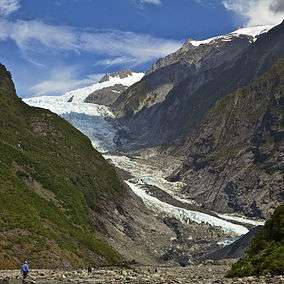
Franz Josef Glacier in 2011 | |
 Map of New Zealand | |
| Location | West Coast, New Zealand |
| Coordinates | 43°23′00″S 170°11′00″E / 43.38333°S 170.18333°ECoordinates: 43°23′00″S 170°11′00″E / 43.38333°S 170.18333°E |
| Area | 1175 km² |
| Established | 1960 |
| Governing body | Department of Conservation |
Westland Tai Poutini National Park is located on the western coast of New Zealand's South Island. Established in 1960, the centenary of the European settlement of Westland District, it covers 1,175 km², and extends from the highest peaks of the Southern Alps to a wild and remote coastline.[1] It borders the Aoraki/Mount Cook National Park along the Main Divide.
Included in the park are glaciers, scenic lakes and dense temperate rainforest, as well as remains of old gold mining towns along the coast. Franz Josef Glacier and Fox Glacier are two popular tourist attractions within Westland Tai Poutini National Park. The park offers hunting opportunities for red deer, chamois and tahr and helicopter access allows hunters access to the rugged mountain areas. The popular Copland Track runs upstream from the Karangarua River bridge. Along with the mountain scenery visible from the track, there are hot springs at Welcome Flat Hut.
In 2010 over 4,400 ha were added to the park, consisting of a number of areas scattered throughout the park, with the majority being to the east of Okarito Lagoon.[2]
See also
- National parks of New Zealand
- Forest parks of New Zealand
- Regional parks of New Zealand
- Protected areas of New Zealand
- Conservation in New Zealand
- Tramping in New Zealand
References
- ↑ "Westland Tai Poutini National Park". Department of Conservation.
- ↑ "New additions to Westland National Park". New Zealand Government. 17 June 2010. Retrieved 17 June 2010.
External links
| Wikimedia Commons has media related to Category:Westland Tai Poutini National Park. |