Westgarthtown, Victoria
Westgarthtown is a heritage registered precinct located within the Melbourne suburbs of Thomastown and Lalor, in Victoria, Australia.[1][2][3]
History
The town was originally known as Germantown, and was established around 1850. The name was changed to Westgarthtown in honour of William Westgarth, who sponsored German immigration. The name Germantown was still in use up until the First World War, when it became officially regarded as part of Thomastown.[4]
Modern day
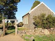
In the 1970s, urban sprawl caught up with the village, and though it is now surrounded by suburban housing, the village is protected by the Victorian Heritage Act. The Lutheran Church (1856) and Cemetery (1850)[5][6][7] and four farmhouses[8][9][10][11] are listed on the Victorian Heritage Register.
References
- ↑ Wuchatsch, Robert (1985), Westgarthtown, the German settlement at Thomastown, R. N. Wuchatsch, ISBN 978-0-9589153-0-4
- ↑ Friends of Westgarthtown, retrieved 2012-01-15
- ↑ Westgarthtown, Heritage Council of Victoria, 2008-10-31, archived from the original on 2009-10-18
- ↑ Allan, Lyle (1986), Review of R.N. Wuchatsch, Westgarthtown, in Journal of Intercultural Studies, Vol 7 No 1 62-63
- ↑ Wuchatsch, Robert, "Westgarthtown", eMelbourne – The Encyclopedia of Melbourne Online, retrieved 2012-01-16
- ↑ "Lutheran Church - Lalor, Victorian Heritage Register (VHR) Number H0899, Heritage Overlay HO30". Victorian Heritage Database. Heritage Victoria.
- ↑ "Westgarthtown Cemetery - Lalor". Victorian Heritage Database. Heritage Victoria.
- ↑ "Wuchatsch's Farm - Lalor, Victorian Heritage Register (VHR) Number H0950, Heritage Overlay HO10". Victorian Heritage Database. Heritage Victoria.
- ↑ "Graff's Farm - Thomastown, Victorian Heritage Register (VHR) Number H0915, Heritage Overlay HO33". Victorian Heritage Database. Heritage Victoria.
- ↑ "Ziebell's Farmhouse - Thomastown, Victorian Heritage Register (VHR) Number H0979, Heritage Overlay HO29". Victorian Heritage Database. Heritage Victoria.
- ↑ "Siebel's Farmhouse - Thomastown, Victorian Heritage Register (VHR) Number H1212, Heritage Overlay HO32". Victorian Heritage Database. Heritage Victoria.
Coordinates: 37°40′18″S 145°0′31″E / 37.67167°S 145.00861°E