Westborough, Massachusetts
- For geographic and demographic information on the census-designated place Westborough, please see the article Westborough (CDP), Massachusetts.
| Westborough, Massachusetts | ||
|---|---|---|
| Town | ||
|
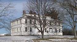
Nathan Fisher House, Westborough | ||
| ||
| Nickname(s): The Hundredth Town | ||
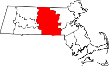
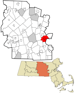 Location in Worcester County and the state of Massachusetts. | ||
| Coordinates: 42°16′10″N 71°37′00″W / 42.26944°N 71.61667°WCoordinates: 42°16′10″N 71°37′00″W / 42.26944°N 71.61667°W | ||
| Country | United States | |
| State | Massachusetts | |
| County | Worcester | |
| Settled | 1675 | |
| Incorporated | 1717 | |
| Government | ||
| • Type | Open town meeting | |
| • Board of Selectmen |
George Barrette Timothy Dodd Denzil Drewry Leigh Emery Ian Johnson | |
| Area | ||
| • Total | 21.6 sq mi (56.0 km2) | |
| • Land | 20.5 sq mi (53.1 km2) | |
| • Water | 1.1 sq mi (2.8 km2) | |
| Elevation | 300 ft (91 m) | |
| Population (2010) | ||
| • Total | 18,272 | |
| • Density | 877/sq mi (338.6/km2) | |
| Time zone | Eastern (EST) (UTC-5) | |
| • Summer (DST) | EDT (UTC-4) | |
| ZIP code | 01581 | |
| Area code(s) | 508/774 | |
| FIPS code | 25-75015 | |
| GNIS feature ID | 0618390 | |
| Website |
town | |
Westborough is a town[1] in Worcester County, Massachusetts, United States. The population was 18,272 at the 2010 Census, in nearly 6,900 households. Incorporated in 1717, the town is governed under the New England open town meeting system, headed by a five-member elected Board of Selectmen whose duties include licensing, appointing various administrative positions, and calling a town meeting of citizens annually or whenever the need arises.
History
Before recorded time, the area now known as Westborough was a well-travelled crossroads. As early as 7,000 BC, prehistoric people in dugout canoes followed the Sudbury and Assabet Rivers to their headwaters in search of quartzite for tools and weapons.
From 1200 to 1600 AD, seasonal migrations brought Nipmuc Indians to hunt and fish near Cedar Swamp and Lake Hoccomocco. Using Fay Mountain as a landmark, Indians crisscrossed Westborough on well-worn paths: the old Connecticut Path leading west from Massachusetts Bay; the Narragansett Trail leading south, and the trail (along the present Milk Street) leading to Canada.[2]
The early English explorer John Oldham followed these trails through Westborough in 1633, and settlers in search of fertile farmlands followed not long after. By late 1675, a few families had settled near Lake Chauncy, in the "west borough" of Marlborough.
On November 18, 1717, Westborough was incorporated as the hundredth town in Massachusetts, populated by twenty-seven families, including Thomas Rice who had represented Marlborough in the Great and General Court. Soon large farms were carved out, mills built along the Assabet River and Jackstraw Brook, and taverns flourished. Westborough's first minister, Reverend Ebenezer Parkman, shepherded the growing town of colonists through the years toward independence from Great Britain. Forty-six minutemen from Westborough fought under Captain Edmund Brigham in the Revolutionary War.
In 1775, Northborough split off as the "north borough" of Westborough, much as Westborough split off from Marlborough some 58 years before. However, the two towns shared a meetinghouse for some time more.
In 1810 the route from Boston to Worcester was straightened and improved into an official turnpike (the present Route 9), and along its Westborough route, the Wesson Tavern Common, Forbush Tavern and Nathan Fisher's store prospered. The center of commerce shifted downtown in 1824 with the arrival of the steam train through Westborough's center. The railroad brought a new era to the town industry: over the next century, local factories shipped boots and shoes, straw hats, sleighs, textiles, bicycles, and eventually abrasive products, across the nation. Westborough dairies supplied cities with milk and local greenhouses shipped out carnations, while the eight orchards found ready markets for their produce.
In 1848 the State Reform School for Boys, the first publicly funded reform school in the United States, was opened on Lake Chauncy. It operated as a State reform school until 1884 at which time the newly established Westborough State Hospital took over the property. In the same year, the reform school was relocated nearby on Chauncy Street and renamed The Lyman School for Boys.

The industrial progress of the entire country is indebted to Westborough's most famous native son Eli Whitney Jr. Born in 1765, Whitney invented the cotton gin in 1795 after graduating from Yale, In 1798 he introduced mass production to the United States at his Whitney Arms Company in New Haven, Connecticut. Whitney's legacy is apparent in the modern industries located within the town's borders: AstraZeneca, Dover Electric, Proteon, Genzyme, EMC Corporation, IBM, PFPC, Bose Corporation and the global headquarters of American Superconductor.
Registered Historic Places
Westborough is home to several listings on the National Register of Historic Places:
- Nathan Fisher House: East of Shrewsbury on MA 9 (added April 25, 1980)
- Joseph Lothrop House: On the corner of Route 9 and Park Street. (added in 1974)
- Lyman School for Boys: Junction of Oak St. and Milk St. (added August 25, 1994)
- Maples Cottage: East of Shrewsbury on Oak St. (added April 25, 1980)
- Vintonville Historic District: Roughly bounded by Cottage, Green, Pine, Brigham, Beach Streets, and rear of properties along the east side of South Street (added August 23, 2006)
- Jonah Warren House: 64 Warren Street (added December 5, 1998)
- West Main Street Historic District: Roughly bounded by Milk, Main, Blake, and Fay streets (added July 16, 1987)
- Expanded to include 83–118 West Main Street (1990)
- Westborough State Hospital: Along Lyman St. North of Chauncy Lake and junction of Milk St. and MA 9 (added February 21, 1994)
Geography
According to the United States Census Bureau, the town has a total area of 21.6 square miles (56.0 km2), of which 20.5 square miles (53.1 km2) of it is land, and 1.1 square miles (2.8 km2) of it is water or 5.09 percent. Westborough is drained by the Sudbury and Assabet rivers. The town contains numerous bodies of water, including Lake Chauncy, Mill Pond, Lake Hoccomocco, and the Westborough Reservoir. Lake Chauncy is open to swimming, boating, and fishing, and has a public beach open to residents of Westborough and Northborough during the summer months. The average elevation of the town is approximately 300 feet (91 m).
Adjacent towns
Westborough is located in east/central Massachusetts, located about 28 miles (45.47 km) west of Boston and 12 miles (19 km) east of Worcester. It is bordered by six towns.
 |
Northborough | Southborough | | |
| Shrewsbury | |
|||
| ||||
| | ||||
| Grafton | Upton | Hopkinton |
Demographics
| Historical population | ||
|---|---|---|
| Year | Pop. | ±% |
| 1850 | 2,371 | — |
| 1860 | 2,913 | +22.9% |
| 1870 | 3,601 | +23.6% |
| 1880 | 5,214 | +44.8% |
| 1890 | 5,195 | −0.4% |
| 1900 | 5,400 | +3.9% |
| 1910 | 5,446 | +0.9% |
| 1920 | 5,789 | +6.3% |
| 1930 | 6,409 | +10.7% |
| 1940 | 6,463 | +0.8% |
| 1950 | 7,378 | +14.2% |
| 1960 | 9,599 | +30.1% |
| 1970 | 12,594 | +31.2% |
| 1980 | 13,619 | +8.1% |
| 1990 | 14,133 | +3.8% |
| 2000 | 17,997 | +27.3% |
| 2010 | 18,272 | +1.5% |
Source: United States Census records and Population Estimates Program data.[3][4][5][6][7][8][9][10][11][12] | ||
Data from the U.S. Census[13] of 2010 shows there were 18,272 people, 6,924 households, and 4,763 families residing in the town (official). The population density was 891.3 people per square mile (unofficial). The latest 2010–2014 American Community Survey (ACS) estimated the town's total population slightly higher, at 18,481, residing in 7,551 households. According to the latest ACS estimate, the racial makeup of the town was 73.8% White, 2.9% Black or African American, 0.3% Native American, 18.3% Asian, 0% Pacific Islander, 1.3% from other races, 3.4% from two or more races, Hispanic or Latino of any race were 6.5% of the population. Westborough has a significant Indian-American Community making up 11.5% of the population, as well as boasting a strong immigrant community with nearly 4,000 residents of non-U.S. origins (21.3%).[14]
According to ACS estimates, there are 4,789 family households out of which 34.8% had children under the age of 18 living with them, 59.3% were married couples living together, 7.2% had a female householder with no husband present, and 32.4% were non-families. Of all households 22.8% were made up of individuals 65 years of age or older. The average household size was 2.54 and the average family size was 3.18.
In addition, the town the population was spread out with 11.5% under the age of 10, 14.3% from 10 to 19, 10.7% from 20 to 29, 11.2% from 30 to 39, 18% from 40 to 49, 16.1% from 50 to 59, 8.6% from 60 to 69, 4.8% from 70 to 79, and 4.9% who were 80 years of age or older. The median age was 42 years. For every 100 females, there were 94.3 males.
The median income for a household in the town (based on U.S. Census ACS five-year estimate) was $105,552, and the median income for a family was $127,623. The per capita income for the town was $45,760. Of the population 4.4% was below the poverty line, including 5.0% of those under age 18 and 3.1% of those age 65 or over. The labor force numbered 10,180 with an unemployment rate in the town of 3.3%. Of the population over age 25, 94.6% graduated high school (or equivalent) and 60.4% hold a bachelor's degree or higher.
Education
Westborough Public Schools consist of three elementary schools, two middle schools and one high school:
- Hastings Elementary School
- Armstrong Elementary School
- Annie E. Fales Elementary School
- Mill Pond School
- Sarah W. Gibbons Middle School
- Westborough High School (school mascot – Rangers)
The Mill Pond School is the newest school addition to Westborough. The Mill Pond School consists of grade 4 to 6, then Gibbons Middle School which consists of grades 7 and 8, and then Westborough High School. There are three options depending upon residents' geographic location in the town for preschool through third grade.
Transportation
The Town of Westborough is located on the west side of the Massachusetts Turnpike (Interstate 90) and Interstate 495 intersection. Route 30 (Main Street) and Route 135 (South Street/Milk Street) intersect in a rotary at the town's center, while Route 9 runs nearby serving much of the town's commerce.
In terms of public transportation, Westborough is currently served by an MBTA commuter rail station on the Framingham/Worcester Line as well as public bus service through the Worcester Regional Transit Authority.Limited commercial airline service is available at the Worcester Regional Airport.The nearest international airport is at Boston.
Government and infrastructure
| County-level state agency heads | |
|---|---|
| Clerk of Courts: | Dennis P. McManus (D) |
| District Attorney: | Joseph D. Early, Jr. (D) |
| Register of Deeds: | Anthony J. Vigliotti (D) |
| Register of Probate: | Stephanie K. Fattman (R) |
| County Sheriff: | Lew Evangelidis (R) |
| State government | |
| State Representative(s): | Carolyn Dykema (D) Danielle Gregoire (D) Hannah Kane (R) |
| State Senator(s): | Jamie Eldridge (D) |
| Governor's Councilor(s): | Marilyn M. Petitto Devaney (D) |
| Federal government | |
| U.S. Representative(s): | James P. McGovern (D-2nd District) |
| U.S. Senators: | Elizabeth Warren (D), Ed Markey (D) |
The Robert F. Kennedy Children's Action Corps, Inc. operates two juvenile correctional facilities in Westborough on behalf of the Massachusetts Department of Youth Services:
- Robert F. Kennedy School, a juvenile correctional center for boys, is in Westborough.[15] – The school is the most secure juvenile facility in the state.[16]
- The Fay A. Rotenberg School, a juvenile correctional facility for girls, is in Westborough.[17] It first opened in North Chelmsford in 1982,[18] but moved to its current location in 2006.[17]
Media
Newspapers:
- Westborough Patch
- The MetroWest Daily News (Framingham)
- The Community Advocate
- The Westborough News
- The Telegram & Gazette (Worcester)
- The Boston Globe (Boston)
- The Boston Herald (Boston)
- Westborough High School Literary Magazine
Broadcast:
- Channel 2: WGBH – (PBS) – Boston
- Channel 4: WBZ – (CBS) – Boston, WBZ-TV
- Channel 5: WCVB – (ABC) – Boston
- Channel 6: WFXT – (FOX) – Boston, FOX 25
- Channel 7: WHDH – (NBC) – Boston, 7 NBC
- Channel 27: WUNI – (Univision) – Worcester
Cablecast (Public, educational, and government access (PEG) cable tv channels):
- Channel 11: Westborough TV – Public-access television (Notices) – Westborough
- Channel 13: Westborough TV – Educational-access television and Area Schools Access Channel – Westborough High School
- Channel 12: Westborough TV – Government-access television Channel – Westborough
Library
The Westborough Public Library began in 1857.[19][20] In fiscal year 2008, the town of Westborough spent 1.24% ($846,826) of its budget on its public library—some $45 per person.[21]
Sites of interest
- Assabet Reservoir – hiking trails
- Fay Mountain – highest point in Westborough
- Lake Chauncy – swimming, boating and fishing
- Lyman School for Boys
- Westborough Charm Bracelet – hiking trail
- Westborough Country Club – semi-private 9-hole, par 36, golf club
- Eli Whitney birthplace, on Eli Whitney Street and marked with a commemorative stone
Accolades
- Money Magazine 2005 profile of Westborough, Massachusetts
- Money Magazine 2007 profile of Westborough, Massachusetts
Annual events
- Annual Boy Scout Troop 100 Pancake Breakfast – February/March
- High School Musical – March
- Taste of the Boroughs – March
- Middle School Musical – April
- Spring Clean Up Day – April
- Spring Carnival – April
- Little League Parade – April
- Memorial Day Parade
- Purple Day-June
- Dress and act like a Pirate Day, May 12
- High School Graduation Ceremony – June
- July 4 Block Party
- Homecoming – September/October
- High School Play – November
- Middle School Play – November
- Thanksgiving Day Football game
- Christmas Singalong
- Westborough High School Winter Concert-December
- Eli Whitney Cup Playoffs (Westborough Men's Softball League)-August
Places of worship
- Beth Tikvah Synagogue
- Chabad of Westborough
- Congregation B'nai Shalom
- Evangelical Congregational Church
- First Baptist Church Westborough
- First United Methodist Church
- Good Shepherd Lutheran Church
- New Hope Chapel
- St. Luke the Evangelist Roman Catholic Church and Rectory
- St. Stephen's Episcopal Church
- Unitarian Universalist Congregational Society of Westborough
- Chapel of the Cross
Notable people
- Eli Whitney Blake, inventor of stone crusher, businessman
- Mary A. Brigham, 8th President of Mount Holyoke College
- Jaime Brockett, folk singer
- Jim Butterfield, American football player and coach. Moved to Westboro as a child.[22]
- Jim Campbell, hockey player
- Andrew Clements, children's author
- Henry W. Corbett, businessman and senator
- Ralph Dawson, film editor
- Louis E. Denfeld, Chief of Naval Operations, United States Navy
- Mark D. Devlin, author
- Esther Forbes, author
- Tod Griffin, actor
- Ashley Hayden, luge athlete
- Richard B. Johnson, author
- Horace Maynard, politician
- Adam Peltzman, writer/producer of Odd Squad
- Thomas Rice, politician and founding citizen
- John Ruggles, politician
- Jordan Smotherman, ice hockey player
- Jeffrey Thomas, science fiction and horror author
- Eli Whitney, inventor and industrialist
- Jack M. Wilson, President of the University of Massachusetts
References
- ↑ Town profile, town.westborough.ma.us; accessed October 3, 2015.
- ↑ The section about Westborough history is based on notes titled The Hundredth Town, written by Kristina N. Allen, which in turn are based on her 1984 book On the Beaten Path.
- ↑ "TOTAL POPULATION (P1), 2010 Census Summary File 1". American FactFinder, All County Subdivisions within Massachusetts. United States Census Bureau. 2010.
- ↑ "Massachusetts by Place and County Subdivision - GCT-T1. Population Estimates". United States Census Bureau. Retrieved July 12, 2011.
- ↑ "1990 Census of Population, General Population Characteristics: Massachusetts" (PDF). US Census Bureau. December 1990. Table 76: General Characteristics of Persons, Households, and Families: 1990. 1990 CP-1-23. Retrieved July 12, 2011.
- ↑ "1980 Census of the Population, Number of Inhabitants: Massachusetts" (PDF). US Census Bureau. December 1981. Table 4. Populations of County Subdivisions: 1960 to 1980. PC80-1-A23. Retrieved July 12, 2011.
- ↑ "1950 Census of Population" (PDF). Bureau of the Census. 1952. Section 6, Pages 21-10 and 21-11, Massachusetts Table 6. Population of Counties by Minor Civil Divisions: 1930 to 1950. Retrieved July 12, 2011.
- ↑ "1920 Census of Population" (PDF). Bureau of the Census. Number of Inhabitants, by Counties and Minor Civil Divisions. Pages 21-5 through 21-7. Massachusetts Table 2. Population of Counties by Minor Civil Divisions: 1920, 1910, and 1920. Retrieved July 12, 2011.
- ↑ "1890 Census of the Population" (PDF). Department of the Interior, Census Office. Pages 179 through 182. Massachusetts Table 5. Population of States and Territories by Minor Civil Divisions: 1880 and 1890. Retrieved July 12, 2011.
- ↑ "1870 Census of the Population" (PDF). Department of the Interior, Census Office. 1872. Pages 217 through 220. Table IX. Population of Minor Civil Divisions, &c. Massachusetts. Retrieved July 12, 2011.
- ↑ "1860 Census" (PDF). Department of the Interior, Census Office. 1864. Pages 220 through 226. State of Massachusetts Table No. 3. Populations of Cities, Towns, &c. Retrieved July 12, 2011.
- ↑ "1850 Census" (PDF). Department of the Interior, Census Office. 1854. Pages 338 through 393. Populations of Cities, Towns, &c. Retrieved July 12, 2011.
- ↑ "American FactFinder". United States Census Bureau. Retrieved 2008-01-31.
- ↑ "American FactFinder". United States Census Bureau. Retrieved 2016-02-02.
- ↑ Kocian, Lisa. "Jail break." Boston Globe. May 15, 2008. 1. Retrieved on August 23, 2010.
- ↑ Kocian, Lisa. "Jail break." Boston Globe. May 15, 2008. 2. Retrieved on August 23, 2010.
- 1 2 "Celebrating 30 Years of Service to Young Women" (Archive). Robert F. Kennedy Children's Action Corps. January 12, 2012. Retrieved on December 24, 2015.
- ↑ "Fay A. Rotenberg School North Chelmsford, Massachusetts" (Archive). Robert F. Kennedy Children's Action Corps. December 30, 2006. Retrieved on December 24, 2015.
- ↑ C.B. Tillinghast. The free public libraries of Massachusetts. 1st Report of the Free Public Library Commission of Massachusetts. Boston: Wright & Potter, 1891.
- ↑ http://www.westboroughlib.org/ Retrieved 2010-11-10
- ↑ July 1, 2007 through June 30, 2008; cf. The FY2008 Municipal Pie: What's Your Share? Commonwealth of Massachusetts, Board of Library Commissioners. Boston: 2009. Available: Municipal Pie Reports; retrieved 2010-08-04
- ↑ UM great, Ithaca coach Jim Butterfield is dead
External links
| Wikimedia Commons has media related to Westborough, Massachusetts. |
- Town of Westborough, Massachusetts
- Westborough Public Library
- Westborough School District
- Westborough Public Access Television
- Westborough.com
| |
Northborough | Southborough | | |
| Shrewsbury | |
|||
| ||||
| | ||||
| Grafton | Upton | Hopkinton |