West Ridge, Chicago
| West Ridge | |
|---|---|
| Community area | |
| Community Area 02 - West Ridge | |
|
Location within the city of Chicago | |
 Streetmap | |
 Location within the city of Chicago | |
| Coordinates: 42°00′N 87°41.4′W / 42.000°N 87.6900°WCoordinates: 42°00′N 87°41.4′W / 42.000°N 87.6900°W | |
| Country | United States |
| State | Illinois |
| County | Cook |
| City | Chicago |
| Neighborhoods | |
| Area | |
| • Total | 3.53 sq mi (9.14 km2) |
| Population (2010) | |
| • Total | 71,942 |
| • Density | 20,000/sq mi (7,900/km2) |
| Demographics 2010 [1] | |
| • White | 42.68% |
| • Black | 11.14% |
| • Hispanic | 20.43% |
| • Asian | 22.5% |
| • Other | 3.25% |
| Time zone | CST (UTC-6) |
| • Summer (DST) | CDT (UTC-5) |
| ZIP Codes | 60645 and parts of 60659 |
| Median Household income[2] | $47,323 |
| Source: U.S. Census, Record Information Services | |
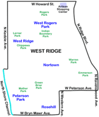
West Ridge is one of 77 Chicago community areas. It is a middle-class neighborhood located on the far North Side of the City of Chicago. It is located in the 50th Ward. Also historically called North Town, and frequently referred to as West Rogers Park, it is bordered on the north by Howard Street, on the east by Ridge Boulevard, Western Avenue, and Ravenswood Avenue, the south by Bryn Mawr Avenue and Peterson Avenue, and on the west by Kedzie Avenue and the North Shore channel of the Chicago River. At one time joined with neighboring Rogers Park, it separated in the 1890s over a conflict concerning park districts (known as the Cabbage War.)
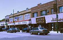
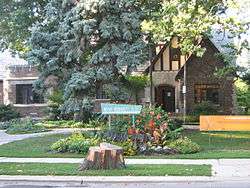
Today West Ridge is one of Chicago's better off communities, filled with thriving multi-ethnic culture lining Devon Avenue, historic mansions lining Ridge and Lunt Avenues, cultural institutions such as St. Scholastica Academy and one of the highest per capita incomes on the North Side of Chicago. It had been represented in the Chicago City Council by Alderman Bernard Stone from 1973 until May 2011. On April 5, 2011, Alderman Debra Silverstein defeated Stone in a runoff election[3] and now represents the 50th Ward, which encompasses West Ridge.
It is home to the Midwest's largest Hasidic community, as well as other Jewish, Irish American, German-American, Indian, Pakistani, Bangladeshi, Assyrian, Russian, and Korean immigrant communities.
Golden Ghetto
The Golden Ghetto is bounded on the north by Warren Park and Pratt Avenue and on the south by Peterson Avenue. It acquired its name from the thriving Jewish community there from about 1930 to the mid-1970s. That community began to drift into the suburbs in the 1960s, and the neighborhood began to be home to South Asians and Russian Jews from about that time.
The heyday of the area is the topic of Adam Langer's Crossing California, told from the perspective of the second-generation residents during their middle school and teenage years.
Schools
Public schools
Chicago Public Schools operates public schools.
- Clinton Elementary School
- Jamieson Elementary School
- Daniel Boone Elementary School
- Stephen Decatur Classical School
- George Armstrong Elementary School
- Philip Rogers Elementary School
- Stone Scholastic Academy
- West Ridge Elementary School
- Mather High School
Private schools
- ABC Academy
- Bethesda Evangelical Lutheran School
- Bnos Rabbeinu High School
- Cheder Lubavitch Girls High School
- Hanna Sacks Bais Yaakov High School
- Joan Dachs Bais Yaakov High School
- Keshet High School
- NAES College
- Victor C. Neumann School[4]
- St. Hilary Elementary School
- St. Margaret Mary School
- St. Philips Evangelical Lutheran School
- Tzemach Tzedek Elementary School (Opened 2002)[5]
- Yeshivas Brisk
- Yeshiva Migdal Torah School
- Yeshiva Ohr Baruch-Veitzner Chedder
Historical population
| Historical population | |||
|---|---|---|---|
| Census | Pop. | %± | |
| 1930 | 39,759 | — | |
| 1940 | 43,553 | 9.5% | |
| 1950 | 47,930 | 10.0% | |
| 1960 | 63,884 | 33.3% | |
| 1970 | 65,477 | 2.5% | |
| 1980 | 61,129 | −6.6% | |
| 1990 | 65,374 | 6.9% | |
| 2000 | 73,199 | 12.0% | |
| 2010 | 71,942 | −1.7% | |
Source:[6]
References
- ↑ Paral, Rob. "Chicago Demographic Data".
- ↑ Paral, Rob. "Chicago Census Data". Retrieved 22 September 2012.
- ↑ "Election results Stone v. Silverstein". Retrieved 18 May 2011.
- ↑ Banas, Casey. "SCHOOL MAY REOPEN TO EASE CROWDING." Chicago Tribune. July 17, 1985. Chicagoland 4. Retrieved on February 5, 2011. "Neumann School, a private school for emotionally disturbed children,[...]"
- ↑ "General Information." Tzemach Tzedek Elementary School. Retrieved on February 5, 2011.
- ↑ Paral, Rob. "Chicago Community Areas Historical Data". Chicago Community Areas Historical Data. Retrieved 29 August 2012.
External links
- Official City of Chicago West Ridge Community Map
- Chicago Park District: Indian Boundary Park
- Lakeside Community Development Corporation
- Photographs of Devon Avenue by Jordan Bettis
- Rogers Park West Ridge Historical Society
 |
Skokie, Illinois | Evanston, Illinois | | |
| Lincolnwood, Illinois | |
Rogers Park, Chicago | ||
| ||||
| | ||||
| North Park, Chicago | Lincoln Square, Chicago | Edgewater, Chicago |