West Mountain (Utah)
| West Mountain | |
|---|---|
 The summit of West Mountain, with the radio tower farm. | |
| Highest point | |
| Elevation | 6,912 ft (2,107 m) NAVD 88[1] |
| Prominence | 2,104 ft (641 m) [2] |
| Coordinates | 40°03′19″N 111°49′46″W / 40.055410072°N 111.829509706°WCoordinates: 40°03′19″N 111°49′46″W / 40.055410072°N 111.829509706°W [1] |
| Geography | |
 West Mountain Location in Utah | |
| Location | Utah County, Utah, U.S. |
| Parent range | Wasatch Range |
| Topo map | USGS West Mountain |
| Climbing | |
| Easiest route | Access road |

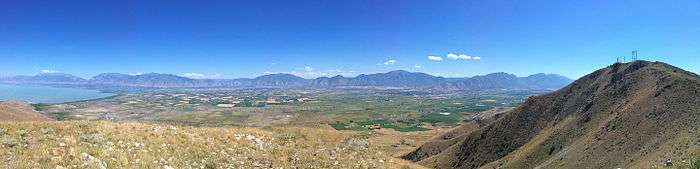
West Mountain is a mountain located 15.35 miles (25 km) southwest of Provo, Utah and 4.7 miles (8 km) west of Benjamin, Utah. It is home to a radio station tower for KTCE, an FM station licensed to Payson, Utah and operating on 92.1 MHz. The mountain is also home to various FM radio translators and an observatory used by students from Brigham Young University. It can be accessed from a main road that starts near Benjamin, Utah. A small census designated place east of the mountain is known as West Mountain as well.
Geology
West Mountain's highest point is at 6,805 feet (2,074 m). The mountain is on the southern segment of the Wasatch Range, though it is not connected to the main range. The mountain is located on the southern shore of Utah Lake.[2]
Radio uses
The following are translators and radio stations located on the mountain (in order of frequency):
- K202CC-88.3 FM, from parent station KAWZ-FM
- K208BZ-89.1 FM from parent station KBYU-FM.
- KTCE-92.1-FM, a hot adult contemporary format station licensed to Payson, Utah.
- K252DB-98.3 FM, from parent station KEGH.
As well as radio stations, the mountain houses several cellular telephone transmitters providing service for AT&T Wireless, Verizon Wireless and T-Mobile. The mountain also contains towers for local emergency services, and state and federal government services.[3] An older tower, once operated by AT&T, is known more commonly as a "Long Line" tower, and was used for microwave communications is located on the summit. It is the tallest tower on the mountain, and is the most predominant feature. With the invention of fiber optics, the use of these towers gradually declined, and other similar towers have fallen into disrepair.[4] This particular "long lines" tower, is connected to other towers in Riverton, Utah and Levan, Utah. A ham radio repeater, known as WA7FFM is located on the mountain as well.
Observatory
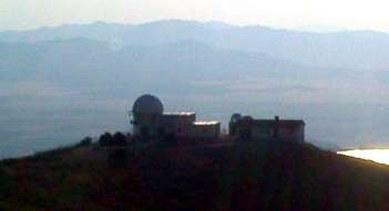
West Mountain Observatory, which is operated by nearby Brigham Young University (BYU), is located just southwest of the summit of West Mountain. It was constructed for the astronomy department of BYU in 1981 and houses three telescopes.[5]
Access
West Mountain road, which leads to the summit, begins on Lincoln Beach road, directly northeast of the summit. It is a winding road, which may or may not be in good condition, depending on the season. Those wishing to access the mountain are suggested to use four wheel drive vehicles.[6]
References
- 1 2 "M 27". NGS data sheet. U.S. National Geodetic Survey. Retrieved 2016-04-23.
- 1 2 "West Mountain, Utah". Peakbagger.com. Retrieved 2016-04-23.
- ↑ BLM - Communication Site
- ↑ AT&T Long Lines Microwave Towers Remembered
- ↑ "West Mountain Observatory". Brigham Young University Department of Physics and Astronomy. Retrieved 2011-01-14.
- ↑ West Mountain RTLI info
External links
| Wikimedia Commons has media related to West Mountain (Utah). |