West Montrose, Ontario
| West Montrose | |
|---|---|
| Unincorporated community | |
|
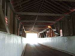
Covered bridge at West Montrose in Autumn. | |
| Coordinates: 43°35′18″N 80°28′55″W / 43.58833°N 80.48194°W | |
| Country | Canada |
| Province | Ontario |
| Regional municipality | Waterloo |
| Township | Woolwich |
| Time zone | EST (UTC-5) |
| • Summer (DST) | EDT (UTC-4) |
| Forward sortation area | N0B 2V0 |
| Area code(s) | 519 and 226 |
| NTS Map | 040P09 |
| GNBC Code | FDCNQ |


West Montrose is a village in the Township of Woolwich in the Region of Waterloo, Ontario, Canada. West Montrose straddles the Grand River, one of Canada's historic rivers.Together with nearby St. Jacobs, Ontario and Elmira, Ontario, West Montrose lies in the heart of an area where there is a historically large settlement of Old Order Mennonites noted for their traditional customs, dress and use of horse and buggies.
History
West Montrose was settled in 1806 by Scots from Montrose, Scotland. The village was an industrious community in the past with a woolen mill, saw mill, lime kiln, feed mill, two blacksmith shops, shoemaker and several stores. In 1902 the railway built tracks and a station north of the village to transport goods and livestock. Today the peaceful village is surrounded by Mennonite farms and most of the people living in the community commute to larger centres to work. The more recent outlying town is home to many large residences.
"Kissing Bridge"

The West Montrose Covered Bridge was constructed in 1881 by John and Benjamin Bear and is best known for being the last remaining historical covered bridge in Ontario. These bridges were known colloquially as 'kissing bridges' since couples would be out of sight as they passed through the bridge. While the original bridge was constructed entirely of wood, in a series of repairs and restorations the bridge uses a combination of materials but retains its original form. In 1960 the bridge was recognized as an historic site by the Ontario Archaeological and Historic Sites Board and was designated as a heritage site in 1975.
The Region of Waterloo, in collaboration with the Township of Woolwich and local residents, is committed to maintaining the West Montrose Covered Bridge as a viable open bridge with the appropriate limitations to ensure that the heritage integrity of the structure is conserved.
Please note: The West Montrose Covered Bridge has a 3 tonne load limit and should not be crossed by trucks, buses, tractors or other heavy vehicles.
See also
References
External links
- Ontario Plaques - The West Montrose Covered Bridge
- Bridgekeepers Association
- West Montrose at Geographical Names of Canada
Coordinates: 43°35′18″N 80°28′55″W / 43.58833°N 80.48194°W