West Hempstead, New York
| West Hempstead, New York | |
|---|---|
| Hamlet and census-designated place | |
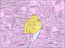
 Location in Nassau County and the state of New York. | |
 Location within the state of New York | |
| Coordinates: 40°41′47″N 73°39′9″W / 40.69639°N 73.65250°WCoordinates: 40°41′47″N 73°39′9″W / 40.69639°N 73.65250°W | |
| Country | United States |
| State | New York |
| County | Nassau |
| Area | |
| • Total | 2.8 sq mi (7.1 km2) |
| • Land | 2.7 sq mi (6.9 km2) |
| • Water | 0.1 sq mi (0.2 km2) |
| Elevation | 66 ft (20 m) |
| Population (2010) | |
| • Total | 18,862 |
| Time zone | Eastern (EST) (UTC-5) |
| • Summer (DST) | EDT (UTC-4) |
| ZIP code | 11552 |
| Area code(s) | 516 |
| FIPS code | 36-80225[1] |
| GNIS feature ID | 0969246[2] |
West Hempstead is a hamlet and census-designated place (CDP) in Nassau County, New York, United States. The population was 18,862 at the 2010 census. West Hempstead is an unincorporated area in the Town of Hempstead and is represented by Councilman Bruce Blakeman.
History
West Hempstead is served by the West Hempstead Branch of the Long Island Rail Road. There are 3 stations within its borders: West Hempstead, Hempstead Gardens, and Lakeview. The line continues to Valley Stream where it joins the Babylon Branch.
West Hempstead is easily accessed from the Southern State Parkway at Exit 17N.
The West Hempstead Union Free School District currently operates 5 schools; 1 kindergarten, 2 elementary, 1 middle school and 1 high school.
Geography
West Hempstead is located at 40°41′47″N 73°39′9″W / 40.69639°N 73.65250°W (40.696409, -73.652522).[3]
According to the United States Census Bureau, the CDP has a total area of 2.8 square miles (7.3 km2), of which, 2.7 square miles (7.0 km2) of it is land and 0.1 square miles (0.26 km2) of it (3.64%) is water.
Demographics
As of the census[1] of 2000, there were 18,713 people, 6,024 households, and 4,867 families residing in the CDP. The population density was 7,039.1 per square mile (2,716.2/km²). There were 6,110 housing units at an average density of 2,298.3/sq mi (886.9/km²). The racial makeup of the CDP was 82.69% White, 5.94% African American, 0.17% Native American, 5.08% Asian, 0.02% Pacific Islander, 3.21% from other races, and 2.89% from two or more races. Hispanic or Latino of any race were 9.94% of the population.
There were 6,024 households out of which 38.1% had children under the age of 18 living with them, 66.3% were married couples living together, 11.0% had a female householder with no husband present, and 19.2% were non-families. 15.9% of all households were made up of individuals and 8.3% had someone living alone who was 65 years of age or older. The average household size was 3.09 and the average family size was 3.47.
In the CDP the population was spread out with 26.2% under the age of 18, 7.3% from 18 to 24, 29.1% from 25 to 44, 23.0% from 45 to 64, and 14.4% who were 65 years of age or older. The median age was 37 years. For every 100 females, there were 95.5 males. For every 100 females age 18 and over, there were 90.7 males.
The median income for a household in the CDP was $71,260, and the median income for a family was $78,481. Males had a median income of $51,391 versus $35,871 for females. The per capita income for the CDP was $26,732. About 3.4% of families and 4.7% of the population were below the poverty line, including 5.4% of those under age 18 and 3.4% of those age 65 or over.
Notable people
- Devon Cajuste, Stanford Cardinal wide receiver and NFL Draft prospect. Lived in West Hempstead.[4]
- Nathan Englander, American short story writer and novelist, was born and raised in West Hempstead.[5]
- Kalomoira, popular Greek singer, was born in West Hempstead.[6]
- Lucien Laurin, award-winning horse trainer who won the Belmont Stakes by 31 lengths in 1973. Laurin also trained the champion, Riva Ridge, who won the Kentucky Derby & Belmont Stakes in 1972.
- Don McPherson, former National Football League and Canadian Football League quarterback. 1987 Heisman Trophy finalist. Went to West Hempstead High School.[7]
- Mark Mendoza, bassist of Twisted Sister, was born and raised in West Hempstead.
- Andrew Stewart, former National Football League lineman for the Cleveland Browns. Went to West Hempstead High School.[8]
- Walt Whitman, American poet, essayist and journalist. In 1840, he was the headmaster of the West Hempstead-based District 17 Schoolhouse.[9]
- Orville Wright Inventor of powered flight, lived in West Hempstead in the early 1930s.
Local activities
- The West Hempstead Chiefs Soccer Club, has girls and boys teams at both the intramural level and the LIJSL Travel division level.[10]
References
| Wikivoyage has a travel guide for West Hempstead. |
- 1 2 "American FactFinder". United States Census Bureau. Retrieved 2008-01-31.
- ↑ "US Board on Geographic Names". United States Geological Survey. 2007-10-25. Retrieved 2008-01-31.
- ↑ "US Gazetteer files: 2010, 2000, and 1990". United States Census Bureau. 2011-02-12. Retrieved 2011-04-23.
- ↑ Holy Cross' Devon Cajuste giving defenders big fits, gains attention
- ↑ Nathan Englander - From the Author
- ↑ Long Island's Kalomira Sarantis Competing in Antenna's "Fame Story"
- ↑
- ↑
- ↑
- ↑ "West Hempstead Chiefs".