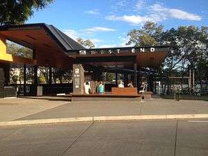
West End ferry wharf
West End | |||||||||||
|---|---|---|---|---|---|---|---|---|---|---|---|
 | |||||||||||
| Location | Orleigh Street, West End | ||||||||||
| Coordinates | 27°29′25″S 153°00′12″E / 27.4902°S 153.0034°ECoordinates: 27°29′25″S 153°00′12″E / 27.4902°S 153.0034°E | ||||||||||
| Owned by | Brisbane City Council | ||||||||||
| Construction | |||||||||||
| Bicycle facilities | yes | ||||||||||
| Disabled access | Yes | ||||||||||
| Other information | |||||||||||
| Fare zone | 2 (TransLink) | ||||||||||
| History | |||||||||||
| Rebuilt | 2011[1] | ||||||||||
| Services | |||||||||||
| |||||||||||
West End is a ferry wharf in the suburb of West End used by the CityCat on the Brisbane River.
In January 2011 the wharf was destroyed during the devastating floods and the building works of the upgraded terminal were expected to be completed in July 2011.[2][3]
The new wharf was officially opened on July 24.[1]
References
- 1 2 Calligeros, Marissa (2011-07-25). "West End CityCat Terminal Re-Opens After Brisbane Flood". Brisbane Times. Retrieved 2011-08-02.
- ↑ Vogler, Sarah (April 18, 2011). "All CityCat terminals except West End get back on deck". The Courier-Mail. Retrieved 7 May 2011.
- ↑ "West End CityCat terminal upgrade". BCC. Retrieved 28 June 2011.
External links
| Wikimedia Commons has media related to West End ferry terminal. |
This article is issued from Wikipedia - version of the 8/4/2015. The text is available under the Creative Commons Attribution/Share Alike but additional terms may apply for the media files.