West Carrollton, Ohio
| West Carrollton, Ohio | |
|---|---|
| City | |
|
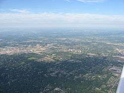
Aerial view of West Carrollton/ Miamisburg | |
 Location in Montgomery County and the state of Ohio. | |
| Coordinates: 39°40′5″N 84°14′53″W / 39.66806°N 84.24806°WCoordinates: 39°40′5″N 84°14′53″W / 39.66806°N 84.24806°W | |
| Country | United States |
| State | Ohio |
| County | Montgomery |
| Government | |
| • Mayor | Jeffery W. Sanner |
| Area[1] | |
| • Total | 6.66 sq mi (17.25 km2) |
| • Land | 6.44 sq mi (16.68 km2) |
| • Water | 0.22 sq mi (0.57 km2) |
| Elevation[2] | 702 ft (214 m) |
| Population (2010)[3] | |
| • Total | 13,143 |
| • Estimate (2012[4]) | 13,099 |
| • Density | 2,040.8/sq mi (788.0/km2) |
| Time zone | Eastern (EST) (UTC-5) |
| • Summer (DST) | EDT (UTC-4) |
| ZIP code | 45449 |
| Area code(s) | 937 |
| FIPS code | 39-83111[5] |
| GNIS feature ID | 1065462[2] |
| Website | www.westcarrollton.org |
West Carrollton is a city in Montgomery County, Ohio, United States. The population was 13,143 at the 2010 census.[6] It is part of the Dayton Metropolitan Statistical Area. The Great Miami River runs through the town and forms most of its northern border.
Geography
West Carrollton is located at 39°40′5″N 84°14′53″W / 39.66806°N 84.24806°W (39.668050, -84.247991).[7]
According to the United States Census Bureau, the city has a total area of 6.66 square miles (17.25 km2), of which 6.44 square miles (16.68 km2) is land and 0.22 square miles (0.57 km2) is water.[1]
Demographics
| Historical population | |||
|---|---|---|---|
| Census | Pop. | %± | |
| 1850 | 226 | — | |
| 1870 | 350 | — | |
| 1890 | 360 | — | |
| 1900 | 987 | 174.2% | |
| 1910 | 1,285 | 30.2% | |
| 1920 | 1,430 | 11.3% | |
| 1930 | 2,101 | 46.9% | |
| 1940 | 2,176 | 3.6% | |
| 1950 | 2,876 | 32.2% | |
| 1960 | 4,749 | 65.1% | |
| 1970 | 10,748 | 126.3% | |
| 1980 | 13,148 | 22.3% | |
| 1990 | 14,403 | 9.5% | |
| 2000 | 13,818 | −4.1% | |
| 2010 | 13,143 | −4.9% | |
| Est. 2015 | 12,980 | [8] | −1.2% |
| Sources:[5][9][10][11][12][13] | |||
2010 census
As of the census[3] of 2010, there were 13,143 people, 5,973 households, and 3,378 families residing in the city. The population density was 2,040.8 inhabitants per square mile (788.0/km2). There were 6,522 housing units at an average density of 1,012.7 per square mile (391.0/km2). The racial makeup of the city was 86.8% White, 8.9% African American, 0.3% Native American, 1.1% Asian, 0.9% from other races, and 2.0% from two or more races. Hispanic or Latino of any race were 2.6% of the population.
There were 5,973 households of which 27.3% had children under the age of 18 living with them, 37.4% were married couples living together, 13.4% had a female householder with no husband present, 5.7% had a male householder with no wife present, and 43.4% were non-families. 35.1% of all households were made up of individuals and 10.7% had someone living alone who was 65 years of age or older. The average household size was 2.18 and the average family size was 2.81.
The median age in the city was 37.5 years. 21.1% of residents were under the age of 18; 9.7% were between the ages of 18 and 24; 29.3% were from 25 to 44; 25.4% were from 45 to 64; and 14.5% were 65 years of age or older. The gender makeup of the city was 48.2% male and 51.8% female.
2000 census
As of the census[5] of 2000, there were 13,818 people, 6,134 households, and 3,704 families residing in the city. The population density was 2,190.7 people per square mile (845.5/km²). There were 6,562 housing units at an average density of 1,040.3 per square mile (401.5/km²). The racial makeup of the city was 92.59% White, 5.21% African American, 0.21% Native American, 1.18% Asian, 0.01% Pacific Islander, 0.51% from other races, and 1.30% from two or more races. Hispanic or Latino of any race were 1.44% of the population.
There were 6,134 households out of which 27.4% had children under the age of 18 living with them, 45.0% were married couples living together, 11.4% had a female householder with no husband present, and 39.6% were non-families. 32.0% of all households were made up of individuals and 8.6% had someone living alone who was 65 years of age or older. The average household size was 2.24 and the average family size was 2.83.
In the city the population was spread out with 22.2% under the age of 18, 10.1% from 18 to 24, 32.8% from 25 to 44, 22.5% from 45 to 64, and 12.4% who were 65 years of age or older. The median age was 35 years. For every 100 females there were 92.3 males. For every 100 females age 18 and over, there were 88.6 males.
The median income for a household in the city was $40,964, and the median income for a family was $48,832. Males had a median income of $38,382 versus $25,591 for females. The per capita income for the city was $20,721. About 6.1% of families and 7.4% of the population were below the poverty line, including 12.9% of those under age 18 and 6.9% of those age 65 or over.
History
West Carrollton was originally called Carrollton, and under the latter name was laid out in 1830.[14]
References
- 1 2 "US Gazetteer files 2010". United States Census Bureau. Retrieved 2013-01-06.
- 1 2 "US Board on Geographic Names". United States Geological Survey. 2007-10-25. Retrieved 2008-01-31.
- 1 2 "American FactFinder". United States Census Bureau. Retrieved 2013-01-06.
- ↑ "Population Estimates". United States Census Bureau. Retrieved 2013-06-17.
- 1 2 3 "American FactFinder". United States Census Bureau. Retrieved 2008-01-31.
- ↑ "American FactFinder2". Retrieved 2010-03-20.
- ↑ "US Gazetteer files: 2010, 2000, and 1990". United States Census Bureau. 2011-02-12. Retrieved 2011-04-23.
- ↑ "Annual Estimates of the Resident Population for Incorporated Places: April 1, 2010 to July 1, 2015". Retrieved July 2, 2016.
- ↑ "Population: Ohio" (PDF). 1910 U.S. Census. U.S. Census Bureau. Retrieved 28 November 2013.
- ↑ "Population: Ohio" (PDF). 1930 US Census. U.S. Census Bureau. Retrieved 28 November 2013.
- ↑ "Number of Inhabitants: Ohio" (PDF). 18th Census of the United States. U.S. Census Bureau. Retrieved 22 November 2013.
- ↑ "Ohio: Population and Housing Unit Counts" (PDF). U.S. Census Bureau. Retrieved 22 November 2013.
- ↑ "Incorporated Places and Minor Civil Divisions Datasets: Subcounty Population Estimates: April 1, 2010 to July 1, 2012". U.S. Census Bureau. Retrieved 25 November 2013.
- ↑ Overman, William Daniel (1958). Ohio Town Names. Akron, OH: Atlantic Press. p. 141.
External links
Municipalities and communities of Montgomery County, Ohio, United States | ||
|---|---|---|
| Cities | 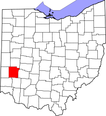 | |
| Villages | ||
| Townships | ||
| CDPs | ||
| Unincorporated communities | ||
| Ghost towns | ||
| Footnotes | ‡This populated place also has portions in an adjacent county or counties | |