West African Craton

The West African Craton is one of the five large masses, or cratons, of the Precambrian basement rock of Africa that make up the African Plate, the others being the Kalahari craton, Congo craton, Saharan Metacraton and Tanzania Craton. These land masses came together in the late Precambrian and early Palaeozoic eras to form the African continent. At one time, volcanic action around the rim of the craton may have contributed to a major global warming event.[1]
Location and composition
The craton appears to have formed when three Archean cratons fused: Leo-Man-Ghana, Taoudeni and Reguibat. The first two docked around 2,100 Ma (million years ago), and the Reguibat Craton docked with the craton around 2,000 Ma. The roots of the combined craton extend to a depth of over 300 km in the sub-continental lithospheric mantle.[2]
The West African Craton stretches from the Little Atlas mountains of Morocco to the Gulf of Guinea, and is bounded by mobile belts of much younger rocks to the north, east and west. The oldest rocks were metamorphosed 2,900 to 2,500 million years ago. In the Sahara they are mostly covered by more recent sediments from the Phanerozoic Eon. Further south, younger volcanic and sedimentary rocks outcrop in Ghana, Ivory Coast, and Sierra Leone, surrounded by even younger sediments laid down in the Precambrian.[3]
The West African Craton underlies the modern countries of Morocco, Algeria, Mauritania, Senegal, The Gambia, Guinea Bissau, Guinea, Mali, Burkina Faso, Sierra Leone, Liberia, Ivory Coast, Ghana, Togo and Benin.
Wanderings
The Earth formed about 4.6 billion years ago.[4] As it cooled the lithosphere, consisting of the crust and the rigid uppermost part of the mantle solidified. The lithosphere rides on the asthenosphere, which is also solid but can flow like a liquid on geological time scales. The lithosphere is broken up into tectonic plates, which slowly move in relation to one another at speeds of 50–100 mm annually, colliding, combining into continents, splitting and drifting apart to form new continental configurations.[5]
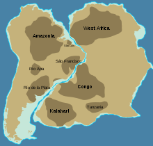
It is difficult to reconstruct the early wanderings of the West African Craton, but around 1,100 million years ago it seems to have been one of the cratons that came together to form Rodinia, a supercontinent. At that time, the Congo Craton lay to the west of the Amazonia Craton, and the West African Craton lay to the south of them (rotated about 180°, they retain this relative configuration.)[6]
Around 750 million years ago Rodinia rifted apart into three continents: Proto-Laurasia, the Congo craton and Proto-Gondwana.[7] The West African Craton may then have combined with other cratons to form Pannotia, a hypothetical supercontinent that existed from the Pan-African orogeny about 600 million years ago to the end of the Precambrian about 540 million years ago.[8] Later it became part of Gondwana,[9] and later still part of Pangaea, the supercontinent that existed during the Paleozoic and Mesozoic eras about 250 million years ago, before North and South America separated from Eurasia and Africa and the continents started to drift towards their current configuration.[10]
Snowball Earth
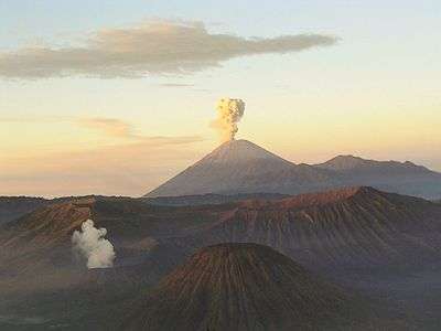
Proponents of the Snowball Earth theory claim that sometime before 650 million years ago the Earth was going through an extremely cold period. The oceans were frozen to great depths, and their snow covering reflected the heat from the sun through cloudless skies. Only simple forms of life could survive in locations such as deep oceanic hydrothermal vents.[11] At the end of this period the edges of the West African craton became highly active, throwing up a ring of volcanoes. The thermal activity was caused by excessive mantle heat that had built up below the craton, insulated by the lithosphere. The volcanic eruptions created a greenhouse effect on massive scale, melting the ice and releasing CO2 into the atmosphere. The climate quickly switched to one much warmer than today, resulting in the Cambrian explosion of life forms.[1]
Features
During its wanderings, at different times covered by ice sheets, forests, marshes or arid desert, the surface of the West African Craton has been heavily eroded by ice, water and wind. In most places the original rocks are buried far below more recent volcanic and sedimentary deposits. The visible features are usually of comparatively recent origin.
Little Atlas Range and Atlas Mountains
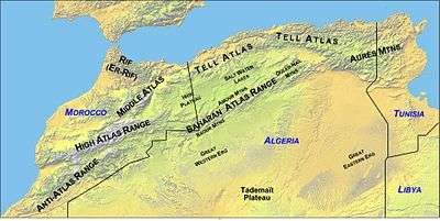
The Little Atlas range formed about 300 million years ago when Euramerica and Gondwana ground against one another during the Alleghenian orogeny, a process that also formed the Appalachians in present-day North America. More recently, in the Cenozoic Era from 66 million to about 1.8 million year ago, the mountain chains that today compose the Atlas Mountains were lifted up as the European and African plates collided at the southern end of the Iberian peninsula. Erosion has reduced the Little Atlas range so that it is today lower than the High Atlas range to the north.[12][13]
Saharan Basins
South of the mountains, the West African Craton is relatively flat, mostly desert or dry savanna apart from the areas near the Atlantic or Gulf of Guinea. However, below the surface there are ancient sedimentary basins such as the Taoudeni basin that may contain large reserves of oil and gas.[14]
Southern region
The southern region of the West African Craton is interrupted by the remains of weathered volcanoes that are younger than the craton itself. Overlaying the Man Shield, the Birimian sequence of metasediments and metavolcanics found in Lower Proterozoic rocks of Ghana, Guinea, Mali, Burkina Faso, Côte d'Ivoire, and Liberia is important as a source of major gold deposits.[15]
References
- 1 2 "Mantle insulation beneath the West African craton during the Precambrian-Cambrian transition". Geological Society of America. September 2002. Retrieved 2009-03-15.
- ↑ G.C. Begg1, W.L. Griffin, L.M. Natapov, Suzanne Y. O'Reilly, S.P. Grand, C.J. O'Neill, J.M.A. Hronsky, Y. Poudjom Djomani, C.J. Swain, T. Deen and P. Bowden (2009). "The lithospheric architecture of Africa: Seismic tomography, mantle petrology, and tectonic evolution". Geosphere. 5 (1): 23–50. doi:10.1130/GES00179.1. Retrieved 2010-12-26.
- ↑ Peter Evans. "African geology". Fortune City. Archived from the original on February 6, 2009. Retrieved 2009-03-15.
- ↑ "Age of the Earth". U.S. Geological Survey. 1997. Retrieved 2006-01-10.
- ↑ Read HH; Watson Janet (1975). Introduction to Geology. New York: Halsted. pp. 13–15.
- ↑ "Rodinia". Palaeos (Toby White). Retrieved 2009-03-15.
- ↑ Torsvik, T.H.; 2003: The Rodinia Jigsaw Puzzle, Science 300, pp. 1379-1381.
- ↑ "Pannotia". Palaeos. Retrieved 2006-03-12.
- ↑ "Geophysical computer model". University of Leeds. Retrieved 21 Oct 2008.
- ↑ Plate Tectonics and Crustal Evolution, Third Ed., 1989, by Kent C. Condie, Pergamon Press
- ↑ Kirschvink, J.L. (1992). "Late Proterozoic low-latitude global glaciation: The snowball Earth". In Schopf, JW; Klein, C. The Proterozoic Biosphere: A Multidisciplinary Study (PDF). Cambridge University Press, Cambridge. pp. 51–52.
- ↑ http://einstein.uab.es/c_geotectonica/WebAtlas/AtlasLitho.htm Potential field modelling of the Atlas lithosphere
- ↑ http://einstein.uab.es/c_geotectonica/WebAtlas/MaterialAtlas/Ayarzaetal2005.pdf Crustal structure under the central High Atlas Mountains (Morocco) from geological and gravity data, P. Ayarza, et al., 2005, Tectonophysics, 400, 67-84
- ↑ Wright, J.B. (1985). Geology and mineral resources of West Africa. London: Allen & Unwin. ISBN 0-04-556001-3.
- ↑ "Projects Liberia: Geological Background". Liberty International Mining Corp. Retrieved 2009-03-15.
External links
- Nasser Ennih & Jean-Paul Liégeois (2008). "The boundaries of the West African Craton, with special reference to the basement of the Moroccan metacratonic Anti-Atlas belt". Geological Society, London. Retrieved 2009-03-16.