Wellington Harbour
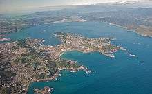
left to right: Lambton Harbour, Miramar Peninsula and the Entrance
Wellington Harbour (Port Nicholson)[1] is the large natural harbour on the southern tip of New Zealand's North Island. New Zealand's capital city, Wellington, is located on its western side. The harbour, the sea area bounded by a line between Pencarrow and Palmer Heads to Petone foreshore, was Port Nicholson until 1984.
In the Māori language the harbour is known as Te Whanganui-a-Tara the great harbour of Tara.[2] Another Māori name for Wellington, Pōneke, is said to be a rendition of Port Nick[3] though a 2005 dictionary has said it was a transliteration of Port Nicholson.[4]
Geography

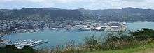
Aotea Quay
.jpg)
Wellington Harbour is an arm of Cook Strait, covering some 76 km², with a two-km wide entrance at its southern end between Pencarrow Head and Palmer Head on the tip of Miramar Peninsula. It has a maximum length of over 11 kilometres and a width of 9.25 kilometres. The harbour has an entrance over 1.6 kilometres wide from shore to shore and as it is surrounded by hills over 300 meters high, it provides sheltered anchorage in a region where wind velocities may exceed 160 k.p.h. The depth of water over the great bulk of the harbour exceeds 20 metres or 10 fathoms.[5]

The harbour is of seismic origin, and a major earthquake fault lies along its western shore. At the northern end of the harbour lies the narrow triangular plain of the Hutt River, which largely follows the line of the earthquake fault to the north-east. The city of Lower Hutt is located on this plain.
The central city suburbs spread around the hills overlooking the west and south-west of Wellington Harbour and its two large bays: Lambton Harbour and Evans Bay. Lambton Harbour is surrounded by the reclaimed land of Wellington's central business district and contains the majority of the city's port facilities. Evans Bay is an inlet between Mt Victoria and the Miramar Peninsula that serves as a flight path to low-lying Wellington Airport. Another smaller but popular bay, for its beaches and Cafes is Oriental Bay. To the east of the harbour lie several small bays, most of which are populated by small coastal communities. The largest of these suburban settlements is Eastbourne, directly to the east of the northern tip of the Miramar Peninsula.
Three small islands are located in the harbour. To the south, close to Eastbourne, is Makaro / Ward Island Further north, close to the centre of the harbour, is the larger Matiu / Somes Island, to the north of which is the tiny Mokopuna Island
The entrance to the harbour can be quite dangerous, especially since Cook Strait to the south is notoriously rough. Close to the harbour's entrance lies Barrett Reef, its rocks breaking the water's surface at low tide. It was here in 1968 that the inter-island passenger ferry Wahine grounded during a storm, with the loss of 51 lives.
.jpg)
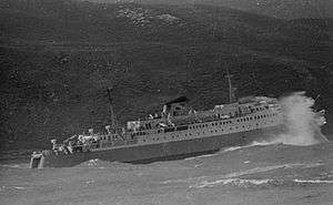 Ferry GMV Aramoana
tackles the entrance in a Cook Strait Southerly 1976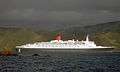 QE2
QE2
slips out the entrance in a following breeze 2006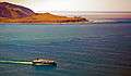 Ferry and Barrett Reef just after low water 2010
Early history
Earlier names of Wellington Harbour
_p044_PART_OF_LAMBTON_HARBOUR%2C_PORT_NICHOLSON%2C_NEW_ZEALAND.jpg)
Wellington Harbour and its waterfront have gone by many names. The earliest known name for Wellington city, derived from Maori legend, is Te Upoko o te Ika a Maui or "the head of Maui's fish".[6] Te Whanganui a Tara is another name Maori gave the area – a name said to come from Whatonga's son Tara, whom his father sent down from the Mahia Peninsula to explore southern lands for their people to settle. It literally means "the great harbour of Tara".[7] Port Nicholson allegedly received its name from Captain James Herd, who sailed into the Harbour of Tara in 1826 and left it with its first European name, calling it after Sydney's Harbourmaster Captain John Nicholson.[8] Colonel William Wakefield allegedly named Lambton Harbour in 1839 in honour of the Earl of Durham, who had the family name of "Lambton".[9]
Reclamation of Wellington Harbour
To increase the amount of usable flat land for Wellington city, the reclamation of Wellington Harbour started in the 1850s.[10]
Transport
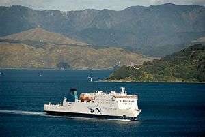
Wellington Harbour is a significant port serving the lower North Island, with the Regional Council-owned company Centreport recording around 14,000 commercial shipping movements each year. Wellington Harbour.[11] The region's third largest container port is located in Wellington City proper [12] and there is a tanker terminal at Seaview, in Lower Hutt. Wellington harbour ferries first began operating at the end of the 19th century and regular crossings from central Wellington to Days Bay continue today. The harbour is also used by inter-island ferries, linking Wellington to Picton.
A project to develop a walking and cycling route around the harbour, the Great Harbour Way, is gathering momentum.
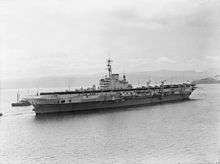 HMS Indefatigable 1945
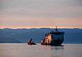 HMNZS Canterbury 2007
 Tugs Kupe and Toia 2006
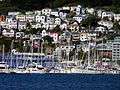 Pleasure craft
2012
References
- ↑ New Zealand Gazette: 1984 (204) p.4798 New Zealand Geographic Board
- ↑ David Allan Hamer & Roberta Nicholls, (editors). The Making of Wellington, 1800-1914, Victoria University Press, 1990 ISBN 0-86473-200-7
- ↑ F. L. Irvine-Smith. The Streets of My City, Wellington New Zealand, A.H. & A.W. Reed, Wellington New Zealand 1948.
- ↑ Tony Deverson and Graeme Kennedy (Ed.) The New Zealand Oxford Dictionary, Oxford University Press, 2005, ISBN 9780195584516
- ↑ A. H. McLintock, (editor). Port Nicholson (Wellington Harbour), An Encyclopaedia of New Zealand, published 1966. ISBN 978-0-478-18451-8
- ↑ http://www.newzealand.com/travel/media/features/maori-culture/maori-culture_wellingtons-maori-history.cfm
- ↑ http://www.wellingtonwaterfront.co.nz/history/index.htm
- ↑ http://www.newzealand.com/travel/media/features/maori-culture/maori-culture_wellingtons-maori-history.cfm
- ↑ http://www.wellingtonwaterfront.co.nz/history/index.htm
- ↑ http://www.wellingtonwaterfront.co.nz/history/waterfront_reclamation/index.htm
- ↑ http://www.gw.govt.nz/Wellington-Harbour/
- ↑ http://www.centreport.co.nz/latest-news/centreport-continues-its-big-ship-agenda
External links
| Wikimedia Commons has media related to Wellington Harbour. |
Coordinates: 41°17′S 174°50′E / 41.283°S 174.833°E