Wayfarer's Walk
| Wayfarer's Walk | |
|---|---|
|
Wayfarer's Walk waymarker | |
| Length | 70 mi (113 km) |
| Location | England |
| Trailheads |
Walbury Hill in West Berkshire 51°21′25″N 1°28′16″W / 51.357°N 1.471°W Emsworth in Hampshire 50°50′38″N 0°55′55″W / 50.844°N 0.932°W |
| Use | Hiking |
| Hiking details | |
| Season | All year |


The Wayfarer's Walk is a long distance footpath in England from Walbury Hill, Berkshire to Emsworth, Hampshire.
The footpath can be walked in either direction. The north-west end is at the car park on top of Walbury Hill, near to the landmark Combe Gibbet, and the south-east end is Emsworth town square.
The footpath approximates an ancient route that might have been used by drovers taking cattle for export. It passes through the towns of New Alresford, Droxford, Hambledon, Havant and Emsworth and the villages of North Oakley, Deane, Dummer, Brown Candover, Abbotstone, Cheriton, Hinton Ampner, Kilmeston, Soberton, and Denmead.
By the path is a memorial to the first flight of Geoffrey de Havilland. The footpath also passes close to Watership Down, Hampshire.
The footpath is waymarked by metal and plastic disks found attached to wooden and metal posts, trees and street furniture. It has also spawned several circular routes that use sections of the main footpath. These are also waymarked.
This route is shown as a series of green diamonds on Ordnance Survey 1:25,000 maps and as a series of red diamonds on Ordnance Survey 1:50,000 maps.
Walbury Hill is also the start of the Test Way and is the start of the Combe Gibbet to Overton 16 Mile Trail Race, the first 11 miles of its route being on Wayfarer's Walk.
Places of interest
The following places of interest, hillfort sites and hills can be found along the length of the Walk (listed from southeast to northwest):
- Fort Purbrook
- The source of the River Itchen
- Tidley Hill
- Watership Down
- Ladle Hill and Iron Age hillfort and SSSI
- Pilot Hill and Dean Hill
- Walbury Hill and the Iron Age hillfort of Walbury Camp
- The start of the Test Way
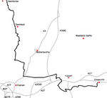
Map
These maps show the footpath in relation to nearby major roads. Maps are not on the same scale.
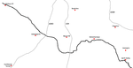 Walbury to North Oakley |
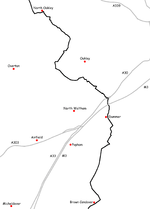 North Oakley to Brown Candover |
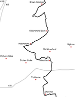 Brown Candover to Cheriton |
 Cheriton to Hambledon |
 Hambledon to Emsworth |
See also
External links
| Wikimedia Commons has media related to Wayfarer's Walk. |
- Hampshire County Council information on the Wayfarer's Walk
- Wayfarer's Walk (Walking on the Web)
- Wayfarer's Walk (Long Distance Walkers’ Association)
- Overton Harriers & AC (Combe Gibbet to Overton 16 Route)
Coordinates: 51°05′42″N 1°10′01″W / 51.095°N 1.167°W