Waverton, New South Wales
| Waverton Sydney, New South Wales | |||||||||||||
|---|---|---|---|---|---|---|---|---|---|---|---|---|---|
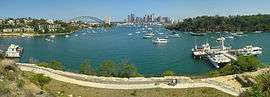 View of Sydney from Waverton | |||||||||||||
|
Waverton | |||||||||||||
| Coordinates | 33°50′25″S 151°11′44″E / 33.84016°S 151.19543°ECoordinates: 33°50′25″S 151°11′44″E / 33.84016°S 151.19543°E | ||||||||||||
| Population | 2,807 (2011 census)[1] | ||||||||||||
| • Density | 3,510/km2 (9,100/sq mi) | ||||||||||||
| Established | 1929 | ||||||||||||
| Postcode(s) | 2060 | ||||||||||||
| Area | 0.8 km2 (0.3 sq mi) | ||||||||||||
| Location | 4 km (2 mi) north of Sydney CBD | ||||||||||||
| LGA(s) | North Sydney Council | ||||||||||||
| State electorate(s) | North Shore | ||||||||||||
| Federal Division(s) | North Sydney | ||||||||||||
| |||||||||||||
Waverton is a suburb on the lower North Shore of Sydney, New South Wales, Australia. Waverton is located 4 kilometres north of the Sydney central business district, in the local government area of North Sydney Council.
History
Waverton was named in 1929 after the Waverton Estate of an early resident, Robert Old. The land once belonged to William Carr, who named it after an English village connected to his family.[2]
The North Shore railway line was extended south from St Leonards to Milsons Point in 1893. The station in this area for nearly forty years was known as Bay Road, after the thoroughfare that crosses the railway line. The local progress association recommended a change and Waverton was chosen in 1929.[3]
Transport
Waverton railway station is on the North Shore, Northern & Western Line of the Sydney Trains network. The naval base HMAS Waterhen is located on Balls Head Road.[4]
Commercial area
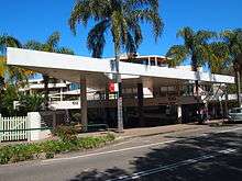
Waverton has a village-like collection of shops around the railway station, including an IGA supermarket,[5] bottle shop, butcher, dry cleaners, chemist and several restaurants and cafes including Grumpy's Cafe, Cafe 2060, Botanica Cafe, Bay Tandoori and Tamarind Thai.
Recreation
Balls Head Reserve, the bushland peninsula, is a popular picnic destination especially when there are harbour fireworks. Its one-way road system also forms part of a favoured route for walkers and joggers. Waverton Park, on the banks of Berry's Bay with stunning views of Sydney Harbour, is another recreation focal point.[6]
References
- ↑ Australian Bureau of Statistics (31 October 2012). "Waverton (State Suburb)". 2011 Census QuickStats. Retrieved 5 November 2012.
- ↑ "Waverton Station Master's Residence". Retrieved 5 May 2013.
- ↑ The Book of Sydney Suburbs, Compiled by Frances Pollen, Angus & Robertson Publishers, 1990, Published in Australia ISBN 0-207-14495-8
- ↑ "Royal Australian Navy - HMAS Waterhen". Retrieved 5 May 2013.
- ↑ "Shops in Waverton". Retrieved 5 May 2013.
- ↑ "North Sydney Council - Balls Head Reserve". Retrieved 5 May 2013.
External links
| Wikimedia Commons has media related to Waverton, New South Wales. |
- Ian Hoskins (2010). "Waverton". Dictionary of Sydney. Retrieved 29 September 2015. [CC-By-SA]