Watsonville Municipal Airport
| Watsonville Municipal Airport | |||||||||||||||
|---|---|---|---|---|---|---|---|---|---|---|---|---|---|---|---|
 Photo of Watsonville Municipal Airport | |||||||||||||||
|
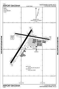
Airport Diagram for Watsonville Municipal Airport | |||||||||||||||
| IATA: WVI – ICAO: KWVI – FAA LID: WVI | |||||||||||||||
| Summary | |||||||||||||||
| Airport type | Public | ||||||||||||||
| Operator | City of Watsonville | ||||||||||||||
| Location | Watsonville, California | ||||||||||||||
| Elevation AMSL | 163 ft / 50 m | ||||||||||||||
| Coordinates | 36°56′09″N 121°47′23″W / 36.93583°N 121.78972°WCoordinates: 36°56′09″N 121°47′23″W / 36.93583°N 121.78972°W | ||||||||||||||
| Map | |||||||||||||||
 WVI Location of airport in California | |||||||||||||||
| Runways | |||||||||||||||
| |||||||||||||||
Watsonville Municipal Airport (IATA: WVI, ICAO: KWVI, FAA LID: WVI) is a public airport located three miles (5 km) northwest of the central business district (CBD) of Watsonville, a city in Santa Cruz County, California, USA.[1] The airport covers 330 acres (134 ha) and has two runways. The largest aircraft to ever land at Watsonville were 05-5141 and 05-5143, C-17 Globemaster IIIs from March ARB, CA.
Facilities
The Watsonville airport's longest runway is 02-20 and its dimensions are 4501' x 149'. The crosswind runway, 09-27, 3998' x 98', is used when winds favor it and when the fog is moving across the field from the Monterey Bay.
The airport is uncontrolled, and the CTAF is 122.8 MHz, and the ASOS can be received on 132.275 MHz or by calling 831-724-8794.
History
The Navy took over in July, 1943, purchased an additional 35 acres, built support buildings and the concrete ramp. On October 23, 1943, the airport was commissioned as Naval Air Auxiliary Station Watsonville (NAAS Watsonville) and served as a satellite to Naval Air Station (NAS) Alameda. As the World War II ended, so did operations at NAAS Watsonville, on Nov. 1, 1945 it was closed and placed on caretaker status
Instrument Approaches
The airport has three approaches, making it a popular instrument training area.
- Localizer Runway 02 (needs overwater flight)
- RNAV (GPS) Runway 02 (needs overwater flight, LPV/WAAS minimums)
- VOR/DME-A (from Salinas VOR)
Instrument pilots have been advised that Watsonville is occasionally surrounded by non-IFR traffic that (illegally) climbs/descends to low stratus layer. ATC usually calls them out, but they can not always see them. There are frequent traffic calls to CTAF even when IMC prevails become important.
See also
References
- ↑ "Watsonville Municipal Airport". Geographic Names Information System. United States Geological Survey. Retrieved 2009-05-03.
External links
- Watsonville Municipal Airport (official site)
- Watsonville Fly In and Airshow
- Watsonville Pilots Association
- Experimental Aircraft Association: Chapter 119
- Monterey Bay Ninety-Nines - local chapter of Ninety Nines organization for women pilots
- CAP Senior Squadron 13 - local Civil Air Patrol squadron, search & rescue and aviation education
- AirMonterey, LLC Part 135 On-Demand Air Charter (Passengers/Cargo)
- Ocean Air Flight Services Flight Training and Maintenance
- United Flight Services Flight Training FBO
- Santa Cruz Flying Club Non-profit Flying Club
- West Coast Sport Aircraft TECNAM Aircraft Regional Distributor
- "Watsonville Airport is a wonderful asset for the city", article in Watsonville Register-Pajaronian, 2009-08-18
- FAA Airport Master Record for WVI (Form 5010 PDF)
- Resources for this airport:
- FAA airport information for WVI
- AirNav airport information for KWVI
- ASN accident history for WVI
- FlightAware airport information and live flight tracker
- NOAA/NWS latest weather observations
- SkyVector aeronautical chart, Terminal Procedures