Waterland
This article is about Waterland, Netherlands. For other uses, see Waterland (disambiguation).
| Waterland | |||
|---|---|---|---|
| Municipality | |||
|
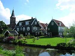
Marken town centre | |||
| |||
.svg.png) Location in North Holland | |||
| Coordinates: 52°27′N 5°2′E / 52.450°N 5.033°ECoordinates: 52°27′N 5°2′E / 52.450°N 5.033°E | |||
| Country | Netherlands | ||
| Province | North Holland | ||
| Established | 1 January 1991 | ||
| Government[1] | |||
| • Body | Municipal council | ||
| • Mayor | Luzette Wagenaar-Kroon (CDA) | ||
| Area[2] | |||
| • Total | 115.66 km2 (44.66 sq mi) | ||
| • Land | 52.11 km2 (20.12 sq mi) | ||
| • Water | 63.55 km2 (24.54 sq mi) | ||
| Elevation[3] | −1 m (−3 ft) | ||
| Population (May 2014)[4] | |||
| • Total | 17,164 | ||
| • Density | 329/km2 (850/sq mi) | ||
| Demonym(s) | Waterlander | ||
| Time zone | CET (UTC+1) | ||
| • Summer (DST) | CEST (UTC+2) | ||
| Postcode | 1140–1156, 1452–1454 | ||
| Area code | 0299 | ||
| Website |
www | ||


Waterland (![]() pronunciation ) is a municipality in the Netherlands, in the province of North Holland. It is located north of Amsterdam, on the western shore of the Markermeer.
pronunciation ) is a municipality in the Netherlands, in the province of North Holland. It is located north of Amsterdam, on the western shore of the Markermeer.
Population centres
The municipality of Waterland consists of the following cities, towns, villages and/or districts: Broek in Waterland, Ilpendam, Katwoude, Marken, Monnickendam, Overleek, Uitdam, Watergang, Zuiderwoude.
Topography
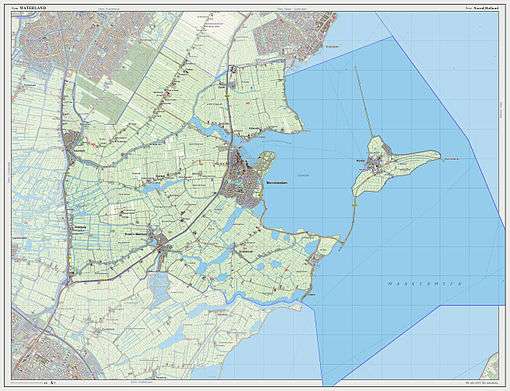
Dutch Topographic map of the municipality of Waterland, 2013.
Local government
The municipal council of Waterland consists (2002) of 17 seats, which are divided as follows:
- CDA - 5 seats
- GroenLinks - 3 seats
- Waterland95 - 3 seats
- Algemeen Belang - 2 seats
- PvdA - 2 seats
- VVD - 2 seats
References
- ↑ "College van burgemeester & wethouders" [Board of mayor and aldermen] (in Dutch). Gemeente Waterland. Retrieved 23 March 2014.
- ↑ "Kerncijfers wijken en buurten" [Key figures for neighbourhoods]. CBS Statline (in Dutch). CBS. 2 July 2013. Retrieved 12 March 2014.
- ↑ "Postcodetool for 1141GV". Actueel Hoogtebestand Nederland (in Dutch). Het Waterschapshuis. Retrieved 23 March 2014.
- ↑ "Bevolkingsontwikkeling; regio per maand" [Population growth; regions per month]. CBS Statline (in Dutch). CBS. 26 June 2014. Retrieved 24 July 2014.
External links
 Media related to Waterland at Wikimedia Commons
- Official website
 |
Purmerend | Edam-Volendam | | |
| Landsmeer | |
Markermeer | ||
| ||||
| | ||||
| Amsterdam |

This article is issued from Wikipedia - version of the 6/23/2015. The text is available under the Creative Commons Attribution/Share Alike but additional terms may apply for the media files.