Watergraafsmeer
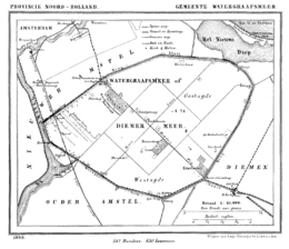
Map of the former municipality Watergraafsmeer in 1869
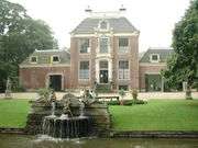
Buitenplaats Frankendael
The Watergraafsmeer is a polder in the Netherlands. It was reclaimed in 1629. In the 17th and 18th centuries, there were many buitenplaatsen in the Watergraafsmeer, though nowadays only one, Frankendael, remains.
Since 1921, the Watergraafsmeer is part of the city of Amsterdam and its rural character has all but disappeared. It is located in the borough of Amsterdam-Oost. The most important streets in the Watergraafsmeer are the Middenweg and the Kruislaan.
Famous persons
- Johan Cruyff, football player
- Gerard Reve, Dutch writer
- Karel van het Reve, Dutch writer, translator, literary historian
- Samuel Jessurun de Mesquita, a graphic artist
Neighborhoods of Amsterdam | ||
|---|---|---|
| Centrum (Centre) | ||
| Nieuw-West (New West) | ||
| Noord (North) | ||
| Oost (East) |
| |
| West | ||
| Zuid (South) | ||
| Zuidoost (Southeast) |
| |
| Westpoort |
| |
Add'l. former boroughs: De Baarsjes - Geuzenveld-Slotermeer - Oost-Watergraafsmeer - Oud-West - Oud-Zuid - Slotervaart - Westerpark - Zeeburg - Zuideramstel | ||
Coordinates: 52°21′N 4°56′E / 52.350°N 4.933°E
This article is issued from Wikipedia - version of the 5/18/2015. The text is available under the Creative Commons Attribution/Share Alike but additional terms may apply for the media files.