Water glyphs
Water glyphs are a recurring type of petroglyph found across the American southwest, but primarily in southern Utah, northern Arizona, and Nevada. The symbols are thought to be of ancient origin, (perhaps created by the Ancient Pueblo Peoples), and have been dated via x-ray fluorescence to around 2,000 years. Classification as a water glyph requires the presence of certain distinctive characteristics including both visual elements and location. Although the glyphs have likely been previously noted by local ranchers and farmers, the recurring pattern was first documented in 1997[1][2]
To date, more than 370 instances of these petroglyphs had been cataloged in an extensive GIS study.[3]
Visual Elements
Water glyphs are usually 48 inches long by 24 inches wide, with grooves carved half an inch to an inch deep.
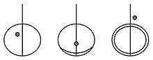
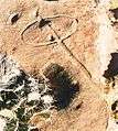
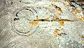
- The symbol consists of a circle or ellipse bisected by a single straight line.
- The line usually extends beyond the edge of the circle on one side by a distance roughly equal to the diameter of the circle.
- Sometimes the extending line drops off the edge of the cliff or rock.
- The petroglyph usually contains a single deep depression, or "dot," within or near the circle.
Examples:
-
Basic glyph
-

Double "front" horizon & multiple "dots"
-
Double horizion
The position of the dot with respect to the glyph varies:
- It may be found outside or within the circle
- It may be found to the right or left of the bisecting line
- It may be found along one of the circular "horizon" lines.
The circle may also contain additional arcs, or partial arcs, forming a crescent on one side of the ring, or a double ellipse; but the basic glyph remains the same.
Location
Many petroglyphs and pictographs are located on cliff faces or under vertical overhangs, where they receive some limited protection from the elements. Water glyphs, however, typically lie along horizontal cliff edges or exposed rock surfaces. Occurrences of water glyphs are sometimes associated with the presence of Moki steps.
Theories
In consideration of the orientations of the line and circle motifs within the pictographs, the authors of this research conclude that waterglyphs are directional markers pointing toward sources of water throughout the arid Arizona Strip.
Amateur archaeologists Robert Ford and Dixon Spendlove assert that the symbols were used by the Ancient Pueblo peoples to mark springs or other important travel information in the desert. They assert that a high percentage of these symbols indicates line-of-sight directions to finding a natural spring, water pocket or pool, or ancient village site. They hypothesize that the symbols could be followed, from one water source to the next, across the entire Arizona Strip.
Opposing theories include use of these petroglyphs as astronomical/solstice markers, sacrificial altars or writings left by early Spanish explorers.
References
- ↑ "WATER TRAILS OF THE ANASAZI", June 25th 1997 @ Udvar-Hazy business building server(http://144.38.20.128/cody/bobby.html) on the Dixie State College Campus
- ↑ Robert Ford and Dixon Spendlove waterglyph research
- ↑ Robert Ford, Dixon & Cody Spendlove, David Maxwell, Gordon Hutchings (Oct 2004), Waterglyphs: Ancient Cartography of the Arizona Strip, Utah Rock Art, Volume 24, page 29, edited by Carol B. Patterson
Publications
- First publication of the research, January 1997
- Waterglyphs: Ancient Cartography of the Arizona Strip published in the September 2004 URARA Symposium Journal
- In Situ: Newsletter of the Nevada Archaeological Association, 2006. Vol 10, No. 2.