Water Orton
| Water Orton | |
 Water Orton |
|
| Population | 3,444 (2011) |
|---|---|
| OS grid reference | SP179927 |
| Civil parish | Water Orton |
| District | North Warwickshire |
| Shire county | Warwickshire |
| Region | West Midlands |
| Country | England |
| Sovereign state | United Kingdom |
| Post town | BIRMINGHAM |
| Postcode district | B46 |
| Police | Warwickshire |
| Fire | Warwickshire |
| Ambulance | West Midlands |
| EU Parliament | West Midlands |
| UK Parliament | North Warwickshire |
|
|
Coordinates: 52°31′01″N 1°44′10″W / 52.517°N 1.736°W
Water Orton is a village near the River Tame in the North Warwickshire borough of Warwickshire in England. It is located between Castle Bromwich and Coleshill, and borders the West Midlands metropolitan county boundary to the north, west and south. At the census in 2001, the population was 3,573, falling to 3,444 at the 2011 Census.[1]
Etymology
Water Orton was first documented in an Assize Roll of 1262 as Overton[2] which means farm by the bank or edge. This usage continued to be recorded through the 13th and 14th centuries, but the name Oreton is recorded in the Warwickshire Feet of Fines in 1431, Water Ouerton is used in the Parish register of Aston in 1546 and Water Ouerton al. Water Orton in the Feet of Fines of 1605 and 1652.[2]
It is now thought that Water Orton may have been included in the Domesday Book in 1086 as 'Wavre' (Over) with Castle Bromwich.[3]
History

The oldest part of the village is centred on the western end of Old Church Road and was designated a conservation area in 1983.[4] This area overlooking the crossing of the River Tame formed the original medieval settlement of Overton and has seen the discovery of pottery remains dating back to the 12th century.[4] It contains a number of listed buildings including The Chestnuts, a 15th century house with late 16th or early 17th century additions that may have been the old manor house; and Wakefield House, a timber framed house with a 17th century main block and a 16th century cross wing.[4]
Water Orton was originally part of the parish of Aston, forming a narrow extension of the parish along the River Tame to the north of the parish of Coleshill.[5] Until the 14th century Water Orton's inhabitants attended ordinary church services at the chapel of ease in Castle Bromwich.[5] In 1346 they built their own chapel and were granted a license to have their own priest, although they remained subject to the mother church of Aston until 1871.[5] The original chapel no longer remains but the graveyard in Old Church Road survives, including the stone village cross dating from 1347.[4]
The present Parish Church of St Peter and St Paul was built in 1879 for £4000 to a design by Bateman and Corser.[6] It had a fine spire, which unfortunately had to be dismantled in the 1980s due to the effects of atmospheric pollution.
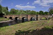
Water Orton Bridge was built in 1520 by John Vesey, the wealthy Sutton Coldfield-born Bishop of Exeter.[7] It replaced an earlier bridge that was recorded as being in a poor state in 1459 when Reginald Boulers, the Bishop of Coventry and Lichfield, offered to issue an indulgence to anybody who would contribute to its repair.[5]
Until the 1840s Water Orton was mainly an agricultural village, but this changed with the coming of the railways. The first one was from Birmingham to Derby via Water Orton, Coleshill, Whitacre Heath and Tamworth. Later a junction was constructed and another line was built via Kingsbury to Tamworth. The lines pass through the centre of the village. The present railway station dates from 1908 and is the second station. There were extensive sidings and much commercial traffic here, especially during and after the Second World War, until the activities of Dr Beeching in the 1960s. An effect of the railway was to increase house building in the village. Commuters could now make the journey to Birmingham's Lawley Street and Curzon Street (later New Street) Railway Stations in a shorter time than by road. This made the village an ideal residential area for Birmingham professionals who wanted to get away from the city and live in the country. The railway also brought the Meat Industry here. There were large stock yards near the sidings and next to the Dog Inn in Marsh Lane. Cattle were offloaded from rail wagons into pens, then driven two miles down the road to butchers' slaughter houses in Castle Bromwich, when meat was provided for nearby villages.
Features
There is a fine Pack Horse Bridge, which is scheduled as an Ancient Monument, over the River Tame on the road to Minworth. It was built by Bishop John Vesey of Sutton Coldfield in 1520.
Water Orton today has a wide variety of services, including: a small High Street with a variety of shops and take aways, two pubs, a Primary School, two other Churches, Doctor and Dental surgeries, two Parks, a Cricket Club (Water Orton CC), a Rugby Club (Old Saltleians RFC) and two amateur football sides. In 2010, a new village hall was completed, called (The Link) replacing the Parish Hall. In addition, Water Orton is home to the amateur dramatics company, (Company of the Curtain), who produced all of their productions in the Parish Hall until December 2008. As well as rail services both in the village, and a short distance away in Coleshill, there is a half-hourly, switching to hourly in the evenings, bus service (number 70; formerly 90) to Birmingham and Coleshill. Some new housing was built during 2003 and 2004. Local events include an annual summer carnival and car boot sales.
Transport
The village is close to the M6, M6 toll and M42 motorways. Water Orton railway station was built in 1842 and is located at the junction of the B4118 and Birmingham Road.
Notable residents and organisations
- The indie band Felt was formed in Water Orton in 1979 by local residents Lawrence and Maurice Deebank.[8]
- Recently, anti-HS2 campaigners have been very active in the village, and have formed the Water Orton Stop HS2 Action Group.
- Ex-Aston Villa striker Stefan Moore owns a Water Orton taxi firm.
References
- ↑ "Civil Parish population 2011". Retrieved 2 January 2015.
- 1 2 "Water Orton (Settlement) located in the Parish of Water Orton". The Historical Gazetteer of England's Place-Names. Queen's University Belfast, the University of Nottingham, the University of Edinburgh and King's College London. Retrieved 2016-11-13.
- ↑ Gethin, Bryn; Wright, Kevin (2012). Plank Lane, Water Orton, Warwickshire: Archaeological Evaluation (Report). Archaeology Warwickshire Report. 1208. Archaeology Warwickshire. p. 5. Retrieved 2016-11-13.
- 1 2 3 4 "Water Orton Conservation Area - Designation Report". Conservation areas in the Borough of North Warwickshire (Report). North Warwickshire Borough Council. 1995. pp. 89–96. Retrieved 2016-11-13.
- 1 2 3 4 Salzman, L. F., ed. (1947). "Parishes: Water Orton". A History of the County of Warwick: Volume 4, Hemlingford Hundred. Victoria County History. London. pp. 262–263. Retrieved 2016-11-13.
- ↑ Nikolaus Pevsner and Alexandra Wedgwood, The Buildings of England, Warwickshire, 1966, ISBN 0-14-071031-0
- ↑ Historic England. "Water Orton Bridge (332032)". PastScape. Retrieved 2016-11-13.
- ↑ Gilbert, Nick; Pierce, Kevin (1993). Box Set (CD Booklet). Felt. London: Cherry Red. BOX 1 CD.
- Walmley and its surroundings (Chapter VIII: Water Orton), Douglas V. Jones, 1990, Westwood Press (ISBN 0-948025-11-5)
- Water Orton Station
External links
| Wikimedia Commons has media related to Water Orton. |