Watauga River
| Watagua river | |
| Watoga[1] | |
| River | |
 The Watauga River near Valle Crucis, North Carolina | |
| Name origin: Native American | |
| Country | United States |
|---|---|
| State | NC/TN |
| Regions | Blue Ridge and, Ridge-and-Valley Physiographc Provinces |
| Source | spring |
| - location | Peak Mountain, Avery County, North Carolina |
| - elevation | 4,082 ft (1,244 m) |
| - coordinates | US 36°07′25″N 81°50′07″W / 36.12361°N 81.83528°W |
| Mouth | confluence |
| - location | Holston River, South Fork near Gray, Tennessee, Tri-Cities Region |
| - elevation | 1,384 ft (422 m) |
| - coordinates | US 36°26′50″N 82°25′15″W / 36.44722°N 82.42083°WCoordinates: US 36°26′50″N 82°25′15″W / 36.44722°N 82.42083°W |
| Length | 78.5 mi (126 km) |
| Basin | 867.849 sq mi (2,248 km2) |
 Locator - Overview | |
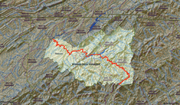 Watauga River Watershed | |
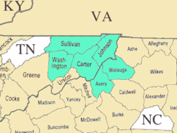 Counties touched or traversed by the Watauga River. | |
The Watauga /wɑːˈtɑːwɡɑː/ [2] River is a large stream of western North Carolina and East Tennessee. It is 78.5 miles (126.3 km) long with its headwaters on the slopes of Grandfather Mountain and Peak Mountain in Watauga County, North Carolina.
Course
The Watauga River rises from a spring near the base of Peak Mountain at Linville Gap in Avery County, North Carolina. The spring emanates from the western side of the Tennessee Valley Divide, which is, at this location, congruent with the Eastern Continental Divide. On the other side of the divides at Linville Gap are the headwaters of the Linville River in the Upper Catawba Watershed. Waters of the Linville River eventually reach the Atlantic Ocean, whereas waters of the Watauga River reach the Gulf of Mexico; hence the Eastern Continental Divide. The river then flows across Watauga County, North Carolina crossing the Tennessee state line (River Mile (RM) 55.1) at Johnson County, then into Carter County, Tennessee and ends at its confluence with the Holston River's South Fork (RM 0) on the Washington/Sullivan County border.
Impoundment
After crossing into Johnson County, the Watauga River is first impounded by the Tennessee Valley Authority (TVA) Watauga Dam, creating the 6,430-acre (2,600 ha) Watauga Lake.[3] This impoundment receives two important tributaries: the Elk River, and Roan Creek. Watauga Lake is bridged by Tennessee State Route 67 over Butler Memorial Bridge just as the watercourse enters Carter County, Tennessee. The Appalachian Trail crosses the river on Watauga Dam.
Nearly 3 miles below Watauga Dam, on the Horseshoe section of the Watauga River, is the TVA Wilbur Dam, which forms a much smaller but very deep reservoir known as Wilbur Lake. TVA releases approximately 130 cubic feet per second (3.7 m3/s) of discharged water back into the Watauga River during the summer months.[4]
Below Wilbur Dam the river flows generally north and then west into Carter County where it forms the northern limits of Elizabethton, where the Watauga then receives the Doe River. Farther downstream on the Watauga River at the boundary between Carter County and Washington County is the old TVA Watauga Steam Plant.
A portion of the boundary line between Washington County and Sullivan County is formed by the Watauga River. Boone Dam is located below the slack water confluence of both South Fork Holston River and the downstream end (mouth) of the Watauga River. The distance afloat between the TVA Watauga Reservoir and Boone Lake is approximately 20.6 miles (33.2 km).[5]
History
The true origin of the name of the Watauga River is probably lost to antiquity. Most documents agree the name is of Native American origin though which nation, tribe or language it descends, and its meaning, is questionable. A North Carolina State University web page (The Watauga Medal) says the word "Watauga" is a Native-American word meaning "the land beyond".[6] Another source states Watauga is possibly derived from a Cherokee word, more accurately written Watagi. Other common spellings include Watoda, Wattoogee, and Whatoga.[7] Yet another source suggests the word “Watauga” comes from the Yuchi phrase meaning "bass many.".[8] However, local reference to the name is attributed as meaning "beautiful river" or "beautiful water". There were at least two Native American villages so named, including one at present-day Elizabethton, which became known as "Watauga Old Fields", first explored by Daniel Boone and James Robertson in 1759. Another village called Watauga was located on the Little Tennessee River near Franklin, North Carolina.
The original settlers of Nashville, Tennessee, set out from the Watauga River area, called the Watauga Association, during the American Revolution when they realized that the British Proclamation of 1763 forbidding settlement of its colonists west of the Blue Ridge Mountains was essentially unenforceable.[9]

Wilbur Dam is the site of first hydroelectric dam constructed in Tennessee (beginning in 1909), going online with power production and distribution in 1912.[10] Wilbur Dam was constructed by the former Tennessee Electric Power Company, a privately owned utility purchased by TVA in the late 1930s.[10] Elizabethton acquired the moniker "City of Power" because of the early local access to hydro-generated electricity from Wilbur Dam.[11]
Recreation
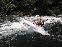
Whitewater rafting, kayaking, canoeing, fly fishing, and angling with fishing reels are all popular recreation activities pursued on the Watauga River. Rainbow trout, brown trout, and striped bass are all caught in the Watauga River.
Whitewater
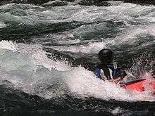
The Watauga River downstream of the TVA dams draws commercial rafting outfitters from both northeast Tennessee and western North Carolina during the summer months and commercial fishing guides throughout the year. The picturesque Class II+ Bee Cliff Rapids on the Watauga River (also referred to the "Anaconda Rapids" by some North Carolina-based rafting companies) are found downstream between Wilbur Dam and the Siam Bridge, southeast of Elizabethton, Tennessee.[12]
For commercial whitewater rafting and kayaking on the Watauga River, the most popular Carter County "put-in" is immediately downstream of the TVA Wilbur Dam, and the most popular "take-out" is 2 to 2½ hours downstream (depending upon the volume of the reservoir release and other factors) at the Blackbottom riverside portion of the city linear trail park in Elizabethton.
The distance afloat for paddlers from the put-in at Wilbur Dam to the Blackbottom take-out is approximately seven miles with landmarks along the Watauga River providing good estimate of time and distance traveled.
Wilbur Dam to Bee Cliff Rapids - 15 minutes Wilbur Dam to Siam Bridge - 45 minutes Wilbur Dam to Hunter Bridge (TWRA put-in/take out) - 75 minutes Wilbur Dam to Gilbert Peters Bridge at US 19-E in Elizabethton - 105 minutes Wilbur Dam to Bristol Bridge in Elizabethton - 135 minutes
The Watauga also has a section of Class IV-V whitewater popular with expert kayakers, upstream of Watauga Lake.[13] This section requires significant rainfall to bring it up to runnable levels. It features continuous steep boulder bed rapids dropping up to 150 feet per mile (28 m/km), and several falls and ledges only runnable by expert paddlers.
TVA recreation areas
The Tennessee Valley Authority maintains a self-service public campground below Watauga Dam. Amenities and recreational opportunities at the TVA Watauga Dam Tailwater Campground include 29 camp sites with electric hookups, rest rooms with heated showers and flush toilets, dump station, public phone, picnic tables and grills, canoe access, boat ramps above and below dam, lake and river fishing, hiking trail, walking trail, wildlife viewing area, birdwatching.[14]
Influence of weather
The Tennessee Valley Authority (TVA) regulates flow of the Watauga River by scheduling the release of deep, impounded reservoir waters from behind both the TVA Watauga Dam and the TVA Wilbur Dam. As a result, the summer temperature of the Watauga River is approximately 52–53°F (11–12 °C) downstream of the TVA dams. The Watauga River is generally comfortable for kayaking, canoeing, and rafting during the summer months, but care must be taken to prevent hypothermia by prolonged exposure to the cold river water.
As TVA also guarantees a minimum release schedule during the summer season for riverine recreation below the TVA Wilbur Dam, the Watauga River will draw commercial whitewater rafting companies from distant rivers—such as the Nolichucky River running through Erwin, Tennessee in Unicoi County[15]—when lack of adequate summer rain fall will not allow for rafting trips on these naturally flowing rivers during seasonal droughts.
| Month | Jan | Feb | Mar | Apr | May | Jun | Jul | Aug | Sep | Oct | Nov | Dec | Annual |
|---|---|---|---|---|---|---|---|---|---|---|---|---|---|
| Avg °F(°C) | |
|
|
|
|
|
|
|
|
|
|
|
|
| Avg high °F(°C) | |
|
|
|
|
|
|
|
|
|
|
|
|
| Avg low °F(°C) | -4.3°C |
-2.9°C |
|
|
|
|
|
|
|
|
|
|
|
| Rain (inches) | |
|
|
|
|
|
|
|
|
|
|
|
|
| Snow (inches) | |
|
|
|
|
|
|
|
|
|
|
|
|
climate-zone.com'[16] | |||||||||||||
See also
| Wikimedia Commons has media related to Watauga River. |
Notes and references
- ↑ "Virginia, North and South Carolina, Georgia, and Florida" (Map). A Map of the British Empire in America with the French and Spanish Settlements adjacent thereto. 1:2,000,000. Willm. Henry Toms & R. W. Seale. 1733 [First published 1733]. Retrieved 14 February 2015.
- ↑ Talk Like A Tarheel, from the North Carolina Collection's website at the University of North Carolina at Chapel Hill. Retrieved 2013-02-05.
- ↑ http://www.tnfish.org/ReservoirLakeInformation_TWRA/TWRA_WataugaReservoirInformation.htm TWRA - Tennessee Wildlife Resources Agency - Watauga Reservoir.
- ↑ http://lakeinfo.tva.gov/htbin/lakeinfo?site=WIH&DataType=All&submit=View%2Binfo TVA. Wilbur Dam.
- ↑ http://www.americanwhitewater.org/content/River_detail_id_1795_ American Whitewater NWRI - Watauga Watauga Reservoir to Boone Lake.
- ↑ http://www.ncsu.edu/watauga/ North Carolina State University - The Watauga Medal.(Login required)
- ↑ Mooney, James. "Myths of the Cherokee". (1900, reprint Dover: New York, 1995)
- ↑ https://decolonialatlas.wordpress.com/category/north-america/
- ↑ Mary Beth Norton; Carol Sheriff; David W. Blight; Howard Chudacoff; Fredrik Logevall (1 January 2011). A People and a Nation: A History of the United States, Volume I: To 1877. Cengage Learning. pp. 144–5. ISBN 0-495-91589-0. Retrieved 17 March 2015.
- 1 2 http://www.tva.gov/sites/wilbur.htm TVA: Wilbur Reservoir
- ↑ http://www.elizabethton.org/ City of Elizabethton
- ↑ http://geonames.usgs.gov/apex/f?p=gnispq:3:::NO::P3_FID:1276768 USGS GNIS - Bee Cliff, Tennessee
- ↑ http://www.americanwhitewater.org/content/River_detail_id_1794 American Whitewater NWRI - Watauga Guys Ford Bridge to Watauga Lake.
- ↑ http://www.tva.gov/river/recreation/camping.htm#watauga TVA: Camping and Recreation Areas - Watauga Reservoir: Watauga Dam Tailwater Campground.
- ↑ http://www.johnsoncitypress.com/Detail.php?Cat=LOCALNEWS&ID=64611 Nolichucky: High water temporarily strands campers; rafting company expects boon in business.
- ↑ www.climate-zone.com
External links
- U.S. Geological Survey Geographic Names Information System: Watauga River
- American Whitewater reach description.
- Watauga River whitewater rafting map.