Washington State Route 433
| ||||
|---|---|---|---|---|
| Oregon Way | ||||
|
SR 433 highlighted in red | ||||
| Route information | ||||
| Defined by RCW 47.17.630 | ||||
| Maintained by WSDOT | ||||
| Length: | 0.94 mi[1] (1.51 km) | |||
| Existed: | 1964 – present | |||
| Major junctions | ||||
| South end: |
| |||
| North end: |
| |||
| Location | ||||
| Counties: | Cowlitz | |||
| Highway system | ||||
| ||||

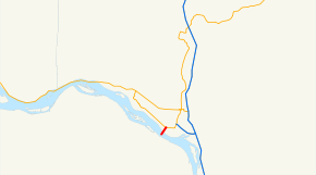
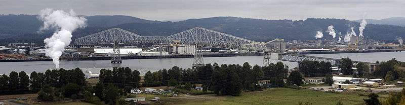
State Route 433 (SR 433) is a 0.94-mile (1.51 km) long state highway located entirely in Cowlitz County, Washington, United States. The highway begins midway across the Columbia River on the National Register of Historic Places listed Lewis and Clark Bridge and travels north to SR 432 in Longview. Prior to the 1964 state highway renumbering the highway was part of Primary State Highway 12. Between 1964 and 1972, the highway's designation was changed from State Route 833 to the current SR 433.
Route description
SR 433 enters Washington and Cowlitz county on the National Register of Historic Places listed Lewis and Clark Bridge over the Columbia River. The highway travels northwest along the bridge for 0.54 mi (0.87 km) before dropping into the city and Port of Longview, intersecting the access road to the Port, Port Way. The highway continues north, paralleling railroad tracks belonging to the Columbia and Cowlitz Railway,[2] intersecting Port Way again, and gaining one lane in each direction for a total of four lanes before the highway terminates at an intersection with SR 432 and Industrial Way.[3] The highway has a posted speed limit of 35 miles per hour (56 km/h) for its entire length.[1] Oregon Way continues after the end of SR 433 into downtown Longview and SR 4.[3]
Every year the Washington State Department of Transportation (WSDOT) conducts a series of surveys on its highways in the state to measure traffic volume. This is expressed in terms of average annual daily traffic (AADT), which is a measure of traffic volume for any average day of the year. In 2009, WSDOT calculated 20,000 vehicles use the highway, with 12 percent of that traffic being trucks.[4] The entire highway is listed on both the WSDOT List of Highways of Statewide Significance,[5] which marks this portion of the highway as critical to connecting major communities in the state, and the National Highway System, a system of roads that are important to the nation's economy, defense and mobility.[6]
SR 433 and the Lewis and Clark Bridge form part of the Seattle to Portland Bicycle Classic, serving as the link between Washington and Oregon on the 202 mi (325 km) long bicycle race held annually.[7]
History
Before the 1964 state highway renumbering the highway was part of Primary State Highway 12.[8] Sometime between the renumbering and 1972 the highway was renumbered from SR 833, a branch of U.S. Route 830 (US 830), to the current SR 433,[9] a branch of SR 4, which replaced US 830 through the area. Until 1992 the highway continued north to Tennant Way,[10] however highway was truncated to Industrial Way.
Major intersections


The entire highway is in Cowlitz County.
| Location | mi[1] | km | Destinations | Notes | |
|---|---|---|---|---|---|
| Columbia River | 0.00– 0.54 | 0.00– 0.87 | Lewis and Clark Bridge Washington–Oregon state line | ||
| Longview | 0.94 | 1.51 | To I-5 via SR 432 | ||
| 1.000 mi = 1.609 km; 1.000 km = 0.621 mi | |||||
References
- 1 2 3 "State Highway Log Planning Report 2009 SR 2 to SR 971" (PDF). Washington State Department of Transportation (WSDOT). p. 1458. Retrieved November 23, 2010.
- ↑ Washington State Rail System (Map). WSDOT. 2009.
- 1 2 Google (November 23, 2010). "SR 433" (Map). Google Maps. Google. Retrieved November 23, 2010.
- ↑ "2009 Annual Traffic Report" (PDF). WSDOT. p. 185. Retrieved November 23, 2010.
- ↑ "List of Highways of Statewide Significance" (PDF). WSDOT. July 26, 2009. p. 2. Retrieved November 23, 2010.
- ↑ "Washington State National Highway System (NHS) Designated Highways" (PDF). November 1, 2002. p. 2. Retrieved November 23, 2010.
- ↑ Group Health Seattle to Portland Bicycle Classic (PDF) (Map). Cascade Bicycle Club. 2010. p. 17. Retrieved November 23, 2010.
- ↑ "Sign Route Numbers with Corresponding Legislative Highway Numbers" (PDF). Washington State Department of Highways. December 1, 1965. p. 14. Retrieved November 23, 2010.
- ↑ Washington Oregon Road Map (Map). 1 in ≈ 17.3 mi. Cartography by Rand McNally. Union 76. 1972. § H5.
- ↑ "Annual Traffic Report" (PDF). WSDOT. 1991. Retrieved November 23, 2010.