Washington State Route 305
| ||||
|---|---|---|---|---|
|
SR 305 is highlighted in red. | ||||
| Route information | ||||
| Auxiliary route of SR 3 | ||||
| Defined by RCW 47.17.560 | ||||
| Maintained by WSDOT | ||||
| Length: |
13.50 mi[1] (21.73 km) Mileage does not include ferry route | |||
| Existed: | 1964[2] – present | |||
| Major junctions | ||||
| South end: |
| |||
|
| ||||
| North end: |
| |||
| Location | ||||
| Counties: | King, Kitsap | |||
| Highway system | ||||
| ||||

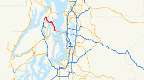
State Route 305 (SR 305) is a 13.50-mile-long (21.73 km) state highway in the U.S. state of Washington, primarily serving Bainbridge Island in Kitsap County and connecting it to Seattle in King County via the Seattle–Winslow Ferry. The highway travels north through Bainbridge Island and leaves the island on the Agate Pass Bridge into the Kitsap Peninsula. SR 305 continues northwest through Poulsbo, intersecting SR 307 and ending at the SR 3 freeway. The highway was created during the 1964 highway renumbering and was preceded by Secondary State Highway 21A (SSH 21A), established in 1937. The ferry, part of the highway since 1994, is served by the Jumbo Mark II class MV Tacoma and MV Wenatchee and operates on a 35-minute crossing time.
Route description
SR 305 begins at Colman Dock in Seattle and travels on the Seattle–Winslow Ferry to Bainbridge Island.[3] The ferry, operated by Washington State Ferries (WSF), is on a 8.6-mile-long (13.8 km) route and is served by the Jumbo Mark II class MV Tacoma and MV Wenatchee, traveling at a speed of 18 knots (21 mph) for a 35-minute crossing.[4][5] The ferries depart from Colman Dock and travel northwest across Elliott Bay and Puget Sound to Winslow, part of the city of Bainbridge Island.[6][7] As of Spring 2013, WSF operates the ferry on 24 weekday crossings and 22 weekend crossings,[8][9] as a $8.00 toll for adult passengers is charged with prepaid Wave2Go cards being accepted.[10]
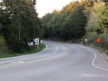
SR 305 leaves the ferry in Winslow on Bainbridge Island and travels north through the island's interior,[11] passing Bainbridge High School before turning northwest near Murden Cove.[12][13] The highway travels over Agate Pass on the truss cantilever Agate Pass Bridge,[14][15] listed on the National Register of Historic Places.[16] SR 305 continues northwest along the coast of Liberty Bay,[17] passing through Lemolo and entering Poulsbo to intersect the southern terminus of SR 307.[18][19] The highway continues northwest to end at a partial cloverleaf interchange with the SR 3 freeway north of the city.[20][21]
Every year, the Washington State Department of Transportation (WSDOT) conducts a series of surveys on its highways in the state to measure traffic volume. This is expressed in terms of average annual daily traffic (AADT), which is a measure of traffic volume for any average day of the year. In 2011, WSDOT calculated that between 5,300 and 27,000 vehicles per day used the highway, mostly in Poulsbo.[22] The Seattle–Winslow ferry was the busiest ferry in the Puget Sound, carrying 6.119 million passengers and 1.194 million vehicles in 2012.[23]
History
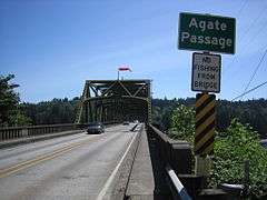
SR 305 was established during the 1964 highway renumbering as a replacement for SSH 21A,[24][25] which traveled 13.45 miles (21.65 km) between the Winslow ferry dock and Primary State Highway 21 (PSH 21) northwest of Poulsbo.[26] SSH 21A originally began at the Port Blakely ferry dock when it was codified in 1937,[27] but was moved north to Winslow in 1949.[28] The highway connected Bainbridge Island to the Kitsap Peninsula via a car ferry that began in the 1920s and was replaced by the 1,229-foot-long (375 m) Agate Pass Bridge after it opened on October 2, 1950 with a 35-cent toll.[29] The bridge, which cost $1.4 million, had its tolls removed in October 1951 after it was paid for by a bond issue passed by the Washington State Legislature.[29][30] The highway was later straightened in segments in the late 1950s by the Department of Highways before becoming SR 305 and being re-codified in 1970.[2][31] SR 305 was extended north to the newly built SR 3 freeway and east on the Seattle–Winslow Ferry to Seattle in 1994.[32][33] No major revisions to the highway have occurred since 1994;[34] however, WSDOT widened SR 305 in 2009 within Poulsbo and installed high-occupancy vehicle lanes (HOV lanes) for use during peak hours.[35][36]
Regular boat service between Bainbridge Island and Seattle began with passenger and freight-carrying steamboats. The Eagle Harbor Transportation Co. operated various steamers on the route, including the Bainbridge and Chippewa,[37][38] until WSF was created in 1951 to manage most ferries in the Puget Sound.[39] WSF operated the MV Tillikum and steam ferry San Mateo on the route, with the MV Illahee used on extra runs. The 2,500-passenger and 160-car Super class MV 'Kaleetan and MV Elwha replaced the older ferries in 1968.[40] The Jumbo Mark II class MV Tacoma and MV Wenatchee were built and placed on the route in 1997 and 1998 respectively to serve growing traffic on the older ferries.[4][5][41]
Major intersections
| County | Location | mi[1] | km | Destinations | Notes |
|---|---|---|---|---|---|
| King | Seattle | 0.00 | 0.00 | Southern terminus | |
| Puget Sound | 0.00 | 0.00 | |||
| Kitsap | Bainbridge Island | 0.00 | 0.00 | Winslow ferry terminal | |
| Agate Pass | 6.80– 7.03 | 10.94– 11.31 | Agate Pass Bridge | ||
| Poulsbo | 12.80 | 20.60 | Southern terminus of SR 307 | ||
| 13.43– 13.50 | 21.61– 21.73 | Northern terminus, interchange | |||
| 1.000 mi = 1.609 km; 1.000 km = 0.621 mi | |||||
References
- 1 2 Staff (2012), State Highway Log: Planning Report 2011, SR 2 to SR 971 (PDF), Washington State Department of Transportation, pp. 1361–, retrieved February 2, 2013
- 1 2 "47.17.560: State route No. 305", Revised Code of Washington, Washington State Legislature, 1994 [1970], retrieved February 2, 2013
- ↑ "Feature Detail Report for: Colman Docks", Geographic Names Information System, United States Geological Survey, September 1, 1990, retrieved February 2, 2013
- 1 2 "M/V Tacoma", Vessel Information, Washington State Ferries, retrieved February 2, 2013
- 1 2 "M/V Wenatchee", Vessel Information, Washington State Ferries, retrieved February 2, 2013
- ↑ "Feature Detail Report for: Puget Sound", Geographic Names Information System, United States Geological Survey, September 10, 1979, retrieved February 2, 2013
- ↑ Seattle Area Route Map (Map). Washington State Ferries. Retrieved February 2, 2013.
- ↑ WSF Sailing Schedule for Seattle / Bainbridge Island, Washington State Ferries, 2013, retrieved February 2, 2013
- ↑ Winter 2013 Sailing Schedule: Seattle / Bainbridge Island (PDF), Washington State Ferries, 2013, retrieved February 2, 2013
- ↑ Passenger and Vehicle Fares (PDF), Washington State Ferries, May 1, 2014, retrieved January 1, 2015
- ↑ "Feature Detail Report for: Bainbridge Island", Geographic Names Information System, United States Geological Survey, September 10, 1979, retrieved February 2, 2013
- ↑ "Feature Detail Report for: Bainbridge High School", Geographic Names Information System, United States Geological Survey, March 1, 1993, retrieved February 2, 2013
- ↑ "Feature Detail Report for: Murden Cove", Geographic Names Information System, United States Geological Survey, September 10, 1979, retrieved February 2, 2013
- ↑ "Feature Detail Report for: Agate Passage", Geographic Names Information System, United States Geological Survey, September 10, 1979, retrieved February 2, 2013
- ↑ "Feature Detail Report for: Agate Pass Bridge", Geographic Names Information System, United States Geological Survey, September 10, 1979, retrieved February 2, 2013
- ↑ National Register of Historic Places - Weekly List of Actions Taken on Properties: 5/22/95 Through 5/26/95 (PDF), United States Department of the Interior, National Park Service, March 1, 1983, p. 32, retrieved February 2, 2013
- ↑ "Feature Detail Report for: Liberty Bay", Geographic Names Information System, United States Geological Survey, September 10, 1979, retrieved February 2, 2013
- ↑ "Feature Detail Report for: Lemolo", Geographic Names Information System, United States Geological Survey, September 10, 1979, retrieved February 2, 2013
- ↑ "Feature Detail Report for: Poulsbo", Geographic Names Information System, United States Geological Survey, September 10, 1979, retrieved February 2, 2013
- ↑ SR 3: Junction SR 305 (PDF), Washington State Department of Transportation, May 2, 2011, retrieved February 2, 2013
- ↑ Google (February 2, 2013). "State Route 305" (Map). Google Maps. Google. Retrieved February 2, 2013.
- ↑ Staff (2011), 2011 Annual Traffic Report (PDF), Washington State Department of Transportation, pp. 172–173, retrieved February 2, 2013
- ↑ WSDOT Ferries Division (WSF) - Nation’s Largest Ferry System (PDF), Washington State Department of Transportation, Washington State Ferries, January 2013, retrieved February 2, 2013
- ↑ Prahl, C. G. (December 1, 1965), Identification of State Highways (PDF), Washington State Highway Commission, Department of Highways, retrieved February 2, 2013
- ↑ Seattle, 1965 (JPG) (Map). 1:250,000. United States Geological Survey. 1965. Retrieved February 2, 2013.
- ↑ Staff (1960), Annual Traffic Report, 1960 (PDF), Washington State Highway Commission, Department of Highways, pp. 216–217, retrieved February 2, 2013
- ↑ Washington State Legislature (March 18, 1937), "Chapter 207: Classification of Public Highways", Session Laws of the State of Washington, Session Laws of the State of Washington (1937 ed.), Olympia, Washington: Washington State Legislature, p. 1011, retrieved February 2, 2013,
(a) Secondary State Highway No. 21A; beginning at Poulsbo on Primary State Highway No. 21, thence in an easterly direction by the most feasible route to Suquamish, thence across Agate Pass to the north end of Bainbridge Island, thence in a southerly direction by the most feasible route to Port Blakely.
- ↑ Washington State Legislature (March 22, 1949), "Chapter 225: Establishing of Primary and Secondary State Highways", Session Laws of the State of Washington, Session Laws of the State of Washington (1937 ed.), Olympia, Washington: Washington State Legislature, pp. 774–775, retrieved February 2, 2013,
(a) Secondary State Highway No. 21A; beginning at a junction with Primary State Highway No. 21 in the vicinity north of Poulsbo, thence in a southeasterly direction by the most feasible route across Agate Pass to the north end of Bainbridge Island, thence in a southerly direction by the most feasible route to the vicinity of Winslow.
- 1 2 Becker, Paula (November 17, 2004), "Agate Pass Bridge connecting the north end of Bainbridge Island to mainland Kitsap County opens on October 7, 1950.", HistoryLink, retrieved February 2, 2013
- ↑ "Agate Pass Spanned", Spokane Daily Chronicle, p. 25, retrieved February 2, 2013
- ↑ Seattle, 1958 (JPG) (Map). 1:250,000. United States Geological Survey. 1958. Retrieved February 2, 2013.
- ↑ Staff (1994), 1994 Annual Traffic Report (PDF), Washington State Department of Transportation, pp. 138–139, retrieved February 2, 2013
- ↑ Washington State Legislature (March 30, 1994), "Chapter 209: Substitute House Bill 2618 - Ferry Routs Included in State Highway Routes", Session Laws of the State of Washington, Session Laws of the State of Washington (1994 ed.), Olympia, Washington: Washington State Legislature, retrieved February 2, 2013,
AN ACT Relating to state highway routes; amending RCW 47.17.080, 47.17.081, 47.17.175, 47.17.305, 47.17.317, 47.17.556, 47.17.560, and 47.17.735; and adding new sections to chapter 47.17 RCW.
- ↑ Washington State Highways, 2011–2012 (PDF) (Map). 1:842,000. Washington State Department of Transportation. 2011. Retrieved February 2, 2013.
- ↑ Moore, Jerry (November 2009), SR 305 - Poulsbo South City Limit to Bond Road - Complete November 2009, Washington State Department of Transportation, retrieved February 2, 2013
- ↑ Morris, Jennifer (June 10, 2008), "SR 305 widening project to wrap in October, weather permitting", North Kitsap Herald, Poulsbo, Washington, retrieved February 2, 2013
- ↑ Newell, Gordon R. (1966), H.W. McCurdy Marine History of the Pacific Northwest, Seattle: Superior Publishing, pp. 90, 254, 325, 351, 372, 425, 593
- ↑ Kline, Mary S. (1983), Ferryboats – A Legend on Puget Sound, Seattle: Bayless Books, p. 53, ISBN 0-914515-00-4
- ↑ Stein, Alan J. (June 2, 2001), "Turning Point 9: The Sound and the Ferry: The Birth of Washington State Ferries", HistoryLink, retrieved February 2, 2013
- ↑ Demoro, Harre (1971), The Evergreen Fleet – A Pictoral History of Washington State Ferries, San Marino, California: Golden West Books, pp. 45–47, ISBN 087095-037-1
- ↑ "State to launch big new ferry", Ellensburg Daily Record, p. 3, August 26, 1996, retrieved February 2, 2013
External links
| ||