Washington State Route 160
| ||||
|---|---|---|---|---|
|
SR 160 is highlighted in red. | ||||
| Route information | ||||
| Auxiliary route of SR 16 | ||||
| Defined by RCW 47.17.305 | ||||
| Maintained by WSDOT | ||||
| Length: |
7.47 mi[1] (12.02 km) Mileage does not include ferry route | |||
| Existed: | 1964[2] – present | |||
| Major junctions | ||||
| West end: |
| |||
|
| ||||
| East end: |
| |||
| Location | ||||
| Counties: | Kitsap, King | |||
| Highway system | ||||
| ||||


State Route 160 (SR 160) is a 7.47-mile-long (12.02 km) long state highway serving Kitsap and King counties in the U.S. state of Washington. The highway begins at an interchange with SR 16 in Port Orchard and travels east to the Southworth ferry terminal, where the route continues onto a ferry to Vashon Heights, the former southern terminus of SR 339, and further east to end at the Fauntleroy ferry terminal in Seattle.
SR 160 was established during the 1964 highway renumbering beginning at SR 16 west of Port Orchard traveling east to Southworth along the Carr Inlet. The corridor was previously a branch of Primary State Highway 14 (PSH 14), established in 1937. The highway was moved south in 1991 and the Southworth–Vashon–Fauntleroy ferry was added in 1994.
Route description
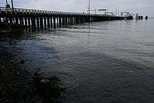
SR 160 begins as Sedgewick Road at a diamond interchange with parent route SR 16 south of Port Orchard in Kitsap County.[3] The highway briefly travels northeast before turning east and entering East Port Orchard,[4] serving a suburban area north of Long Lake.[5] The roadway continues east and passes John Sedgwick Junior High School before turning north into Southworth,[6][7] Within Southworth, Sedgewick Road ends as SR 160 travels onto a ferry route owned and operated by Washington State Ferries (WSF).[8]
The Evergreen State class ferries MV Klahowya and MV Tillikum,[9][10] as well as Issaquah 130 class ferry MV Issaquah serve the route,[11] which travels east from Southworth into King County.[12] The ferries stop at the Vashon Heights terminal,[13] intersecting the now-defunct SR 339 ferry from Vashon to Seattle, before continuing east to the Fauntleroy ferry terminal in West Seattle,[14][15] located in Fauntleroy Cove.[16]
The ferry route is 45 minutes long, as the MV Klahowya and MV Tillikum travel at a speed of 13 knots (15 mph),[9][10] and the MV Issaquah travels at 16 knots (18 mph).[11][17] WSF operates the ferry every weekday with 33 crossings and weekends with 26 crossings,[18] as a $5 toll for adult passengers is charged with prepaid Wave2Go cards being accepted.[19]
Every year the Washington State Department of Transportation (WSDOT) conducts a series of surveys on its highways in the state to measure traffic volume. This is expressed in terms of average annual daily traffic (AADT), which is a measure of traffic volume for any average day of the year. In 2011, WSDOT calculated that between 1,500 and 24,000 vehicles per day used the highway on the Kitsap Peninsula, mostly at the SR 16 interchange in Port Orchard.[20] The Southworth–Vashon–Fauntleroy ferry carried 2.886 million passengers and 1.674 million vehicles in 2012, according to WSF statistics.[21]
History
SR 160 was established in 1964 as a highway beginning at SR 16 west of Port Orchard to Southworth.[2] This highway was originally created in 1923 as a branch of the Navy Yard Highway, signed as State Road 14 from Port Orchard to Harper.[22] The branch was included as part of PSH 14 during the creation of the Primary and secondary state highways in 1937.[23] The PSH 14 branch was extended to Southworth in 1957,[24] and became signed as SR 160 in the 1964 highway renumbering.[2][25] SR 160 was re-aligned south in 1991 to better serve the Southworth–Fauntleroy ferry,[2][26] but the new alignment was temporarily repealed until the creation of SR 166 in 1993.[27] The Southworth–Fauntleroy ferry was added to SR 160 in 1994 along with the rest of the Washington State Ferries.[2][28] No major revisions to the route of the highway have occurred since 1994.[29]
Major intersections
| County | Location | mi[1] | km | Destinations | Notes |
|---|---|---|---|---|---|
| Kitsap | Port Orchard | 0.00– 0.09 | 0.00– 0.14 | Interchange | |
| Southworth | 7.47 | 12.02 | Southworth Ferry Terminal – Vashon, Fauntleroy | ||
| Puget Sound | 7.47– 9.40 | 12.02– 15.13 | |||
| King | Vashon | 9.40 | 15.13 | ||
| Puget Sound | 9.40– 12.80 | 15.13– 20.60 | |||
| 1.000 mi = 1.609 km; 1.000 km = 0.621 mi | |||||
References
- 1 2 Staff (2012), State Highway Log: Planning Report 2011, SR 2 to SR 971 (PDF), Washington State Department of Transportation, pp. 1094–1096, retrieved January 19, 2013
- 1 2 3 4 5 "47.17.305: State route No. 160", Revised Code of Washington, Washington State Legislature, 1970; revised in 1991 (repealed 1992), 1993, 1994, retrieved January 19, 2013 Check date values in:
|date=(help) - ↑ SR 16 - Junction SR 160/Sedgewick Road (PDF), Washington State Department of Transportation, January 27, 2010, retrieved January 19, 2013
- ↑ "Feature Detail Report for: East Port Orchard", Geographic Names Information System, United States Geological Survey, September 10, 1979, retrieved January 19, 2013
- ↑ "Feature Detail Report for: Long Lake", Geographic Names Information System, United States Geological Survey, September 10, 1979, retrieved January 19, 2013
- ↑ "Feature Detail Report for: John Sedgwick Junior High School", Geographic Names Information System, United States Geological Survey, March 1, 1993, retrieved January 19, 2013
- ↑ "Feature Detail Report for: Southworth", Geographic Names Information System, United States Geological Survey, September 10, 1979, retrieved January 19, 2013
- ↑ Google (January 19, 2013). "State Route 160" (Map). Google Maps. Google. Retrieved January 19, 2013.
- 1 2 "M/V Klahowya", Vessel Information, Washington State Ferries, retrieved January 19, 2013
- 1 2 "M/V Tillikum", Vessel Information, Washington State Ferries, retrieved January 19, 2013
- 1 2 "M/V Issaquah", Vessel Information, Washington State Ferries, retrieved January 19, 2013
- ↑ Seattle/Vashon/Tacoma Route Map (Map). Washington State Ferries. Retrieved January 19, 2013.
- ↑ "Feature Detail Report for: Vashon Heights", Geographic Names Information System, United States Geological Survey, September 10, 1979, retrieved January 19, 2013
- ↑ "Feature Detail Report for: Fauntleroy", Geographic Names Information System, United States Geological Survey, September 10, 1979, retrieved January 19, 2013
- ↑ "Feature Detail Report for: Fauntleroy Ferry Landing", Geographic Names Information System, United States Geological Survey, June 17, 2010, retrieved January 19, 2013
- ↑ "Feature Detail Report for: Fauntleroy Cove", Geographic Names Information System, United States Geological Survey, September 10, 1979, retrieved January 19, 2013
- ↑ WSF Sailing Schedule for 2-Boat Fauntleroy / Vashon / Southworth, Washington State Ferries, December 30, 2012, retrieved January 19, 2013
- ↑ Winter 2013 Sailing Schedule: Fauntleroy (West Seattle) / Vashon & Southworth / Vashon (PDF), Washington State Ferries, December 30, 2012, retrieved January 19, 2013
- ↑ Passenger and Vehicle Fares (PDF), Washington State Ferries, May 1, 2012, retrieved January 19, 2013
- ↑ Staff (2011), 2011 Annual Traffic Report (PDF), Washington State Department of Transportation, p. 146, retrieved January 19, 2013
- ↑ WSDOT Ferries Division (WSF) - Nation’s Largest Ferry System (PDF), Washington State Department of Transportation, Washington State Ferries, January 2013, retrieved January 19, 2013
- ↑ Washington State Legislature (March 19, 1923), "Chapter 185: Primary and Secondary State Highways", Session Laws of the State of Washington, Session Laws of the State of Washington (1923 ed.), Olympia, Washington: Washington State Legislature, p. 631, retrieved January 19, 2013,
SEC. 13. A primary state highway, to be known as State Road No. 14 or the Navy Yard Highway, is established as follows: Beginning at a junction with State Road No. 9, at the most feasible point between Shelton and Potlatch in Mason County; thence by the most feasible route through Union City and Clifton to Charleston in Kitsap County; also from a junction near Tidewater Creek in Kitsap County through Port Orchard, to Gig Harbor in Pierce County; also from a junction near Port Orchard by the most feasible route to the ferry landing at Harper.
- ↑ Washington State Legislature (March 17, 1937), "Chapter 190: Establishment of Primary State Highways", Session Laws of the State of Washington, Session Laws of the State of Washington (1937 ed.), Olympia, Washington: Washington State Legislature, p. 940, retrieved January 19, 2013,
SEC. 14. A primary state highway to be known as Primary State Highway No. 14, or the Navy Yard Highway, is hereby established according to description as follows: Beginning at a junction with Primary State Highway No. 9, in the vicinity north of Shelton, thence in a northeasterly direction by the most feasible route by way of Port Orchard, thence in a southerly direction by the most feasible route to Gig Harbor; also beginning in the vicinity of Port Orchard on Primary State Highway No. 14, as herein described, thence in an easterly direction by the most feasible route to the ferry landing at Harper.
- ↑ Washington State Legislature (1957), "Chapter 172", Session Laws of the State of Washington, Session Laws of the State of Washington (1957 ed.), Olympia, Washington: Washington State Legislature, retrieved January 19, 2013
- ↑ Prahl, C. G. (December 1, 1965), Identification of State Highways (PDF), Washington State Highway Commission, Department of Highways, retrieved January 19, 2013
- ↑ Washington State Legislature (May 21, 1991), "Chapter 342: Engrossed Senate Bill 5801", Session Laws of the State of Washington, Session Laws of the State of Washington (1991 ed.), Olympia, Washington: Washington State Legislature,
A state highway to be known as state route number 160 is established as follows: Beginning at a junction with state route number 16 ((
in the vicinity west of)) near Port Orchard, thence ((northeasterly by way of Port Orchard)) easterly to ((Harper and)) the Washington state ferry dock at Point Southworth. - ↑ "47.17.328: State route No. 166", Revised Code of Washington, Washington State Legislature, 2010 [1993], retrieved January 19, 2013
- ↑ Washington State Legislature (March 30, 1994), "Chapter 209: Substitute House Bill 2618", Session Laws of the State of Washington, Session Laws of the State of Washington (1994 ed.), Olympia, Washington: Washington State Legislature,
A state highway to be known as state route number 160 is established as follows: Beginning at a junction with state route number 16 in the vicinity south of Port Orchard, thence easterly on Sedgwick Road to the Washington state ferry dock at Point Southworth; also From the state ferry terminal at Point Southworth via the state ferry system easterly to the state ferry terminal at Vashon Heights; also From the state ferry terminal at Vashon Heights easterly via the state ferry system to the state ferry terminal at Fauntleroy.
- ↑ Washington State Highways, 2011–2012 (PDF) (Map). 1:842,000. Washington State Department of Transportation. 2011. Retrieved January 19, 2013.
External links
Former or proposed: SR 168 | |||